


Contents
1.0
Introduction
This Protocol provides the requirements and procedures for the calculation of net carbon dioxide equivalent (CO2e) removal from the atmosphere via reforestation. Reforestation refers to activities that lead to an increase in forest cover on land that was previously covered by forest, restoring the native forest ecosystem1.
Earth’s forests store approximately 861 gigatonnes of carbon2. Forests can act as a source or sink of carbon, and are estimated to absorb a net 7.6 gigatonnes of CO2 per year3 by converting atmospheric CO2 into biomass through photosynthesis. Carbon is also steadily released from forest biomass through respiration and oxidation, or as a result of disturbances such as timber harvesting, fires, and deforestation.
Reforestation activities include, but are not limited to, planting tree seedlings, facilitating natural regeneration, and/or ongoing management of the forest to maximize and preserve the carbon removed from the atmosphere that is stored in tree biomass. Restoration of forested lands globally could represent an additional storage of 200 gigatonnes of carbon at forest maturity4, making it a useful tool in reaching the projected IPCC Carbon Dioxide Removal (CDR) storage needs of the mid-century. In addition to carbon sequestration potential, reforestation has several co-benefits such as restoration of forest habitat, creation of wildlife corridors, and enhancement of biodiversity on previously degraded lands.
This Protocol accounts for the quantification of the gross amount of CO2 removed via growth and regeneration of forest vegetation, as well as all cradle-to-grave life-cycle Greenhouse Gas (GHG) emissions associated with the process. This Protocol is developed to adhere to the requirements of ISO 14064-2: 2019 – Greenhouse Gasses – Part 2: Specification with guidance at the Project level for quantification, monitoring, and reporting of greenhouse gas emission reductions or removal enhancements.
The Protocol ensures:
- Consistent, accurate procedures are used to measure and monitor all aspects of the reforestation process required to enable accurate accounting of net CO2e removals;
- Consistent system boundaries and calculations are utilized to quantify net CO2e removal for reforestation projects;
- All net CO2e removal claims are verified by a third party;
- Forests that are planted are biodiverse, suitable for the region, and resilient to climate change;
- Removals are additional through the use of dynamic baselines and other guardrails set forth in the Isometric Standard;
- Comprehensive guidance on project design and monitoring mechanisms to confirm Durability and protect against Reversals, ensuring transparent Certificate delivery; and
- Market leakage impacts are quantified.
This Protocol and all standardized approaches therein — including but not limited to the dynamic baseline (Section 9.5) — are informed by the best available scientific knowledge and undergo external review by subject matter experts and relevant stakeholders. All comments received during consultation are publicly addressed, with revisions incorporated as appropriate, to ensure the certified version of the Protocol will yield high quality Carbon Certificates via rigorous, conservative, and appropriate methodologies.
Throughout this Protocol, the use of “must” indicates a requirement, whereas “should” indicates a recommendation.
2.0
Sources and Reference Standards & Methodologies
This Protocol relies on and is intended to be compliant with the following standards and protocols:
- The Isometric Standard
- ISO 14064-2: 2019 - Greenhouse Gases - Part 2: Specification with guidance at the project level for quantification, monitoring, and reporting of greenhouse gas emission reductions or removal enhancements
Additional reference standards that inform the requirements and overall practices incorporated in this Protocol include:
- ISO 14064-3: 2019 - Greenhouse Gases - Part 3: Specification with Guidance for the verification and validation of greenhouse gas statements
- ISO 14040: 2006 - Environmental Management - Lifecycle Assessment - Principles & Framework
- ISO 14044: 2006 - Environmental Management - Lifecycle Assessment - Requirements & Guidelines
Additional principles that were considered in the development of this Protocol and aligned with, where feasible, include:
- The Core Carbon Principles of The Integrity Council for the Voluntary Carbon Market, v1.1, ICVCM, 2024
- Criteria for High-Quality Carbon Dioxide Removal, Relae & Microsoft, 2026
- Ten golden rules for reforestation to optimize carbon sequestration, biodiversity recovery and livelihood benefits, Global Change Biology, 2021
- Quality criteria for afforestation, reforestation, & revegetation projects, Symbiosis, 2026
- ABACUS Label Guidelines, v1.0, Verra, 2024
Protocols and Methodologies that were assessed as part of a literature review during the development of this Protocol include:
- VM0047 Afforestation, Reforestation, and Revegetation, v1.0, Verra, 2023
- Climate, Community & Biodiversity Standards, v3.1, Verra, 2017
- Afforestation - Reforestation GHG Emissions Reductions & Sequestration Methodology, v2.1, Gold Standard
- Quantification Methodology for Terrestrial Forest Restoration, v1.1, Ecosystem Restoration Standard, 2024
- Afforestation/Reforestation/Revegetation (ARR) Carbon Whitepaper, v1.1, Open Forest Protocol, 2024
3.0
Future Versions
This Protocol was developed based on the current state of the art, publicly available science regarding reforestation activities and long-term monitoring of forest carbon projects. This Protocol aims to be scientifically stringent and robust. We recognize that some requirements may exceed the status quo in the market and that there are numerous opportunities to improve the rigor of this Protocol. Key future improvements to the Protocol are outlined in Appendix D.
Additionally, this Protocol will be reviewed when there is an update to published scientific literature, government policies, or legal requirements which would affect net CO₂e removal quantification or the monitoring guidelines outlined in this Protocol, or at a minimum of every 2 years.
4.0
Applicability
This Protocol applies to Projects that aim to restore inland forests to a state of ecological integrity5 in areas where they have historically existed and are resilient to future climate scenarios. Projects should emphasize protection and restoration of ecosystem function, biodiversity, and social livelihoods.
This protocol supports the restoration of native forest ecosystems. Projects that resemble commercial plantation forestry, or that plan for or implement clear-cutting at any point in the Project Commitment Period, fall outside of its scope; the corresponding requirements are set out in Section 4.2. Forests restored under this Protocol are intended to remain standing beyond the Project Commitment Period rather than be clear-cut for timber sale (see Section 5.6).
G-0KF8-0
The geographic Project Boundary must encompass all geographic areas where the Project Proponent is conducting reforestation activities for crediting purposes. This Protocol applies across the temporal (see Section 5) and spatial scope of the Project. The Project Boundary must be set at the time of project initiation and cannot be modified beyond the addition of new Project Areas to the Project once the crediting period begins.
G-501K-0
Any adjacent planting activities or land management by the Project Proponent must be disclosed with justification and evidence that they do not pose any risks to the reforestation activities within the Project Boundary.
Where this Protocol requires an action to be taken:
- with Isometric approval, the Project Proponent must obtain Isometric’s written agreement before Validation or, where the matter arises after Validation, before the action is taken. Evidence of the approval must be included in the PDD or the relevant monitoring report.
- after notifying Isometric, the Project Proponent must inform Isometric before the action is taken, and the VVB assesses compliance at Validation or Verification.
4.1
Ecological Viability of Project
In order to restore ecological integrity and ecosystem function, demonstrate additionality, and ensure trust and transparency, it is incumbent upon Projects to adhere to the following requirements, which must be demonstrated in the Project Design Document:
-
R-NPXT-1Project activities must include reforestation, management for enhanced carbon stocks, and/or assisted natural regeneration on either:
- lands that do not currently meet the definition of a forest6 and whose natural ecosystem is forest, as evidenced under the historical forest presence requirement below; or
- degraded lands, as defined below.
-
G-RMX8-1In the context of this Protocol, degraded lands are areas which currently hold less than the expected biomass of a healthy mature forest, where this is not a result of harvesting within the 10 years prior to project initiation or of ongoing harvesting. For demonstrating eligibility of degraded lands, Project Proponents must provide:
- evidence that the area is degraded, such as biomass below that expected for a healthy mature forest, evidence of degrading factors, or comparison with nearby non-degraded areas; and
- a description of how project activities will address the degrading factors to support full recovery of the forest.
G-C9RX-0Additional removals are quantified through the dynamic baseline (Section 9.5). Acceptable forms of evidence include, but are not limited to, field surveys, peer-reviewed scientific studies, remote sensing data products, and peer-reviewed scientific models (e.g., Walker et al., 20227, Roebroek et al., 20258).
-
Project activities must reforest lands that have historically supported forest ecosystems, and where reforestation would restore landscape-level ecological integrity. In the context of this Protocol, this means that reforestation must restore the natural forest ecosystem of the area.
- R-73F6-1Project activities must not establish forest on land whose natural ecosystem is not forest (e.g., native grassland or savanna), as this constitutes afforestation rather than reforestation.
- G-CH51-0In landscapes where forest and non-forest ecosystems naturally co-occur (e.g., savanna landscapes containing gallery or riparian forest), evidence must relate to the specific areas where project activities occur, and project activities are limited to those areas whose natural ecosystem is forest.
- G-ZYMJ-0This historical forest presence and ecological suitability must be robustly evidenced by data of the following types:
- Land cover classification, in accordance with Section 4.1.1;
- Historical documentation or imagery showing forest presence;
- Scientific analysis of soil composition, pollen records, or other ecological indicators;
- Established scientific consensus regarding the project area’s natural forest biome; and/or
- Traditional ecological knowledge documenting historical forest presence.
- G-X1DW-0Some native ecosystems are dominated by woody vegetation that does not reach the height or canopy cover thresholds of the forest definition at maturity (e.g., subtropical thicket). With Isometric approval, these ecosystems may be treated as forest for the purposes of this Protocol. To obtain approval, Project Proponents must demonstrate in the PDD that:
- the natural ecosystem in the areas where project activities occur (the native ecosystem that would occupy those areas in the absence of human disturbance) is dominated by native woody vegetation, evidenced by the data types listed above for historical forest presence;
- the natural ecosystem is not one in which woody cover is naturally sparse or subordinate to grasses (e.g., grassland or savanna), and project activities will not increase woody cover beyond the level expect for the natural ecosystem at that site, as shown by the evidence above or by comparable intact reference sites; and
- allometric models are available for the dominant species, as required by the Field Plot Quantification Module, including models based on variables other than diameter at breast height (e.g., basal stem diameter, crown area or height).
- R-9BSF-0Project activities must not reforest lands where deforestation occurred within the 10 years prior to project initiation (see Section 4.1.1).
- G-KKG7-1Exceptions are permitted when land clearing at < 10-year intervals is the result of a documented natural disaster or is the result of non-industrial common practice in the region that is unrelated to carbon market activities and incentive. For the latter, evidence must be provided to demonstrate past land ownership and land use, and can include management logs, traditional ecological knowledge, remote sensing data, or photography. The Project Proponent must also provide a timeline of their contact and communication with any current or prior land owners. To further evaluate common practices in the region, Isometric will examine historical deforestation patterns in the region to assess whether there is a consistent pattern of deforestation, which would be indicative of deforestation as non-industrial common regional practice.
- G-060P-0An exception is also permitted where the land was cleared by a third party unrelated to the Project, provided all of the following can be demonstrated:
- the party that cleared the land has no involvement in, or benefit from, the Project;
- neither the Project Proponent nor the landowner initiated or controlled the clearing (e.g., where mineral rights are held separately from surface rights and could be exercised without the landowner’s consent);
- any income the landowner received from the clearing (e.g., royalties) ceased before project initiation; and
- the clearing predates any contact between the Project Proponent and the landowner regarding carbon market activities.
- Evidence must include documentation of land ownership and land use, the arrangement under which the clearing took place, and a timeline of the Project Proponent’s contact and communication with current and prior landowners.
-
R-ED6G-1Project activities must not occur on natural terrestrial or tidal wetlands (e.g., non-forested peatlands, marshes, mangroves), evidenced by soil maps or land cover classification (see Section 4.1.1). For the purposes of this Protocol, natural wetlands are areas that would be wetlands in the absence of human water management (e.g., pumping, levees, impoundments or drainage), including natural wetlands that have been drained or degraded.
-
Seasonally flooded forests, where the natural ecosystem of the project area is forest subject to periodic flooding (e.g., bottomland hardwood floodplain forests), are eligible under this Protocol.
-
G-KTWB-0Peat forests, where the natural ecosystem of the project area is forest on peat soils (e.g., peat swamp forests), are eligible where the Project Proponent:
- provides a risk assessment of emissions and losses from the peat that could result from project activities (e.g., drainage, site preparation, fire, or changes to the water table);
- describes the measures that will be taken to prevent those emissions and losses; and
- demonstrates that the Project will not reduce the peat carbon stock over the Project Commitment Period.
Tidal wetlands (e.g., mangroves) remain excluded.
-
G-7FR0-0Wetlands created or maintained by human water management (e.g., rice cultivation, aquaculture ponds, constructed wetlands) are eligible where the Project Proponent demonstrates that the project area would not hold water in the absence of that infrastructure and that its natural ecosystem is forest. This must be evidenced by a site assessment by a qualified ecologist or hydrologist, supported by soil or hydrological data, in addition to the evidence of historical forest presence required above. Where this evidence demonstrates that an area classified as wetland in land cover data is not a natural wetland, it may be used in place of the land cover classification for this requirement.
-
G-V4KN-0Where project activities include ending water management (e.g., ceasing pumping or opening water control structures), emissions resulting from drainage or flooding, including from loss of soil organic carbon and from nitrous oxide, must be accounted for as GHG emissions from project establishment (see Section 9.6.1), unless the Project Proponent demonstrates that they contribute < 1% of net CO2e removal, both individually and together with all other GHG SSRs omitted from the GHG Statement under the materiality requirements of the GHG Accounting Module (see Section 8.1).
-
The Forest Soil Organic Carbon Quantification Module applies to aerobic soils only and must not be used to quantify soil organic carbon in saturated soils, including losses resulting from drainage.
-
-
R-KEKH-0Projects must not be located in regions where albedo changes lead to a net warming effect. Thus, Projects must not include planting in any areas where a net warming effect is indicated by the data from Hasler et al., 20249, with the threshold being inclusive of biome-specific uncertainty in the data (see Appendix B).
-
G-ESFA-0As an exception, if these assessments indicate the Project includes areas where there is a potential for net warming, Project Proponents must provide additional evidence to justify the climate benefits of the planting in these otherwise excluded areas. This evidence must demonstrate there are still net climate benefits associated with reforestation in the area when also accounting for biophysical effects. Acceptable forms of evidence include local and regional scale peer-reviewed studies and scientific models. While the restoration of nature is an important project benefit, the primary objective of reforestation projects funded by Carbon Finance is to store carbon and mitigate the worst effects of anthropogenic climate change.
4.1.1
Land Cover Classification Requirements
G-7R53-1
Land cover classification is one of several forms of evidence that may be used to demonstrate eligibility under Section 4.1, and is not required where other acceptable evidence is provided. Where land cover data are used, they must be from a documented, publicly available source, with the dataset’s spatial resolution, classification accuracy and temporal coverage reported in the PDD. Examples of land cover datasets are provided in Appendix C.
4.2
Spatial Units
This Protocol uses the following spatial units:
- Discrete planting area: the largest contiguous land area which is subject to the same Project and management activities (e.g., a smallholder farm, land parcel), no smaller than 0.5 ha.
- Project Area: one or more discrete planting areas enrolled in the Project together, sharing a project timeline and Validation (referred to as an instance in the Isometric Registry). A Project may consist of a single Project Area or, under project expansion, multiple Project Areas added over time.
- Project: all Project Areas within the Project Boundary.
Strata are subdivisions used for sampling, which may span discrete planting areas within a Project Area, and are defined in the applicable quantification Module.
4.3
Avoidance of Commercial Forestry Practices
Projects must not occur in regions where significant reforestation activities are driven by market demand, local and/or national incentives, or forestry policies that would lead to forest restoration without Carbon Finance.
- G-Q1DN-0Throughout this Protocol, region is defined by the RESOLVE terrestrial ecoregion10 within the same country as the Project (e.g., Southwest Amazon moist forests in Brazil).
- To determine eligibility, the Project Proponent must provide evidence that the land would not be reforested under baseline conditions, as required by Section 7.4: Additionality and the dynamic baseline approach described in Section 9.6.
G-AP9A-1
Projects must not resemble commercial plantation forestry.
-
Violation of this principle would include monoculture plantations, or plantations limited to several high-value timber species whose composition does not resemble native community assemblages (see Section 4.3), planted in regions where timber is common practice and thus the infrastructure exists to support wood harvesting.
- Minimum species requirements apply to each discrete planting area (see Section 4.3). Meeting the minimum number of species does not by itself demonstrate that a planting is not a monoculture plantation: species should be planted at ecologically appropriate richness and evenness, and planting dominated by a single species is only permitted where it naturally grows in monoculture or dominates during natural succession, as set out above.
- G-78BW-1In cases where a species naturally grows in monoculture within the Project region or there is scientific evidence for a single dominant species during natural succession, Project Proponents may proceed with monoculture planting of this species with Isometric approval as outlined in Section 4.3.
- Where planting of a single dominant species is justified by its dominance during natural succession, the Project Proponent must also provide a succession plan as set out in Section 4.3.
-
Selection harvesting. The following requirements apply to any harvesting within the Project Boundary:
- R-ZGJF-0Selection harvesting, being the sustainable, targeted harvesting of a portion of individual trees or stems on the basis of ecologically-relevant criteria for sustainable forest management (e.g., forest density or tree size, shape, and health), is permissible. Clear-cutting or the complete removal of forest cover must not be planned or implemented at any point during the Project Commitment Period.
- G-9R29-0Project Proponents must include a forest management plan in the PDD, updated at each Verification, specifying harvest intensity (as the proportion of standing carbon stock removed per harvest event) and interval, the criteria for selecting trees, the spatial distribution of harvesting, and all planned and reasonably foreseeable harvests over the Project Commitment Period. Operational records must be maintained and made available at Verification.
- G-XCXY-0Harvesting must maintain canopy structure and continuity, must not result in conversion of the forest, and must exclude High Conservation Values identified under Section 6.3 unless a mitigation strategy has been agreed with Isometric.
- Harvested biomass is not credited. Harvesting must not reduce the carbon stock of the Project below that quantified at the most recent Verification or, during any Ongoing Monitoring Period, below that quantified at the end of the Crediting Period. Any loss of credited carbon stock resulting from harvesting is treated as an avoidable Reversal (see Section 10.3.3). Emissions from harvesting must be included in project emissions.
- Harvesting of non-timber forest products that does not remove woody biomass (e.g., fruit, nuts, resins, leaves) is not subject to these requirements. Harvesting of woody biomass (e.g., fuelwood, poles) is treated as selection harvesting.
4.4
Planting Design
R-H7VK-1
Because of this applicability requirement and the nature of reforestation projects to plant and maintain species in the project area, reforestation projects are well placed to increase biodiversity in the region. To benchmark increased biodiversity, the minimum number of species is applied at the level of discrete planting areas within the Project (see Section 4), and depends on the size of the discrete planting area. If a Project is composed of a single continuous area, these thresholds apply to the total project area. Each discrete planting area must include species from two or more genera, and at least the following number of species:
- Areas less than 25 ha must have 3+ species;
- Areas greater than or equal to 25 ha but less than 100 ha must have 4+ species; and
- Areas greater than or equal to 100 ha must have 5+ species.
For example, a Project consisting of a single continuous area of 200 ha must have at least five species from two or more genera throughout the project area. A Project consisting of a collection of farms, each ranging from 5 to 30 ha in size, must have at least three species in each farm under 25 ha and at least four species in each farm of 25 ha or more, in each case from two or more genera. Discrete planting areas may have different species compositions, provided each meets its minimum.
Species counts include species that are being directly planted or maintained as part of the project interventions, and species where regeneration is anticipated when project interventions include assisted natural regeneration.
G-H1SK-0
Species should be planted at ecologically appropriate richness and evenness11. There may be some regions that naturally support a limited number of species that fulfill ecosystem services and other functions or indicators of healthy ecosystems. Project Proponents in these regions may deviate from the minimum number of species and genera for a discrete planting area with Isometric approval. Such deviations must be accompanied by appropriate documentation, based in scientific literature and/or ongoing field studies, in the PDD. Where planting of a single dominant species is justified by its dominance during natural succession, the succession plan requirements below also apply. For projects where activities include facilitation of natural regeneration and/or ongoing management for enhanced sequestration in lieu of or in addition to direct planting, the above provisions regarding species composition are also applicable to the species which will be the subject of the regeneration and/or management activities.
Where a portion of the minimum species number is expected to materialize via assisted natural regeneration, the Project Proponents must include details of how monitoring will be done to determine if the contributions of assisted natural regeneration to species diversity are being realized. This plan must include provisions for additional interventions (e.g., supplemental planting) if the assisted natural regeneration is insufficient for creating a diverse species mixture. Results of this monitoring must be reported at each Verification.
G-RBGX-0
Where planting of a single dominant species is justified by scientific evidence for its dominance during natural succession (see Section 4.2), the Project Proponent must include a succession plan in the PDD describing:
- the expected successional trajectory, including the species expected to establish as succession advances, supported by peer-reviewed scientific literature and/or field studies conducted at or near the Project site;
- how project activities will facilitate succession and increasing species diversity (e.g., enrichment planting, protection of natural recruitment, maintenance of nearby seed sources);
- how recruitment of additional species will be monitored, including individuals below the minimum size measured in in situ field plots; and
- provisions for additional interventions (e.g., supplemental planting) if succession does not progress as expected.
Progress against the succession plan must be reported at each Verification.
The tree species used for reforestation must follow the principles outlined below and see the Safeguarding of Biodiversity for additional requirements on planting.
4.4.1
Species Selection for Reforestation
R-XJZY-1
The Project Proponent must list the species planted, maintained, and/or regenerated in the project area via project activities in the PDD.
These species may include native, naturalized, or non-native range-expanding species.
G-P12X-1
Project Proponents must not introduce species invasive to the region or similar climates, geographies, or ecosystems of the project area12,13. The definition of 'invasive species' in this Protocol is consistent with the Convention on Biological Diversity's definition of Invasive Alien Species, being a "species whose introduction and/or spread threaten[s] biological diversity"14. Projects that plant invasive species will not be eligible for crediting under this Protocol.
G-9NYJ-0
Additionally, Project Proponents must not introduce any species that harm rare, threatened, or endangered species as defined in Section 6.3.1 or adversely impact the integrity of rare, threatened, or endangered ecosystems and habitats (see Section 6.3). Project Proponents are highly encouraged to consult with Isometric, the VVB, and/or external subject matter experts to ensure that species included in the reforestation plan meet these requirements and the criteria described below.
For the purposes of this Protocol, native species are defined as:
- Species indigenous to the project area that would be found naturally (not planted or introduced anthropogenically via assisted migration) in the project area prior to deforestation or degradation, and/or species that are indigenous to and found naturally in land adjacent to the project area; or
- Species indigenous to the region that have not grown in the Project region for the past 100+ years due to displacement via anthropogenic factors or competition from invasive species, but are still well suited to the climate of the project area, as demonstrated by scientific literature, presence of these species in similar climates, and/or evidence of displacement via one of these two forces.
- Indigenous species that have not existed in the Project region for the past 100+ years due to failure to adapt to changing climatic conditions may not be suitable for reintroduction for the purposes of GHG removal, but may be suitable for other ecosystem benefits. Reintroduction of such species should be done after notifying Isometric.
Naturalized species are defined as:
- Species which occur in the Project region at the time of project initiation, have existed in the project region for 100+ years, and have not threatened biodiversity in the region during that time frame, regardless of indigeneity.
G-C0CJ-0
Reforestation with native species should be the first course of action. If reforestation with only native and naturalized species is not feasible, non-native range-expanding species may be included in the reforestation planting plan. Any non-native species not considered range-expanding for the purposes of this Protocol must not be planted. Non-native range-expanding species are defined as:
- Species whose natural boundaries are expected to overlap with the project area by the end of the Project lifetime and would naturally migrate to and occur within the project boundaries without human-intervention; or
- Species that currently exist in the same RESOLVE terrestrial biome10 as the project area, and where peer-reviewed literature or government agency documentation supports the species assisted migration as an adaptation response to climate change, and where such migration is projected to occur naturally over time due to climate change.
G-XAT7-1
In such instances, the majority of species planted must be native and/or naturalized, and the plurality must be native species.
Additionally, the following due diligence must be taken when planting non-native range-expanding species for a Project to be eligible for crediting. The Project Proponent must demonstrate:
- G-4MHH-1Reforestation with native species will hinder the Project Proponent’s ability to meet project objectives:
- Introduction of native species will lead to negative ecosystem impacts.
- Native species will fail to thrive and contribute significantly to the carbon stock over the course of the Reporting Period. This may occur if the species lack climate resilience, marked by increased vulnerability to temperature fluctuations, changes in water availability, competition from invasive species, disease, etc.
- Reforestation via non-native range-expanding species will bring net positive ecosystem or community impacts that could not otherwise be achieved.
- Non-native range-expanding species are expected to serve as pioneer species for successional planting of native species, as demonstrated in scientific, peer-reviewed literature and/or in other reforestation projects in the same or similar regions.
Alternative burdens of proof may be accepted with Isometric approval.
G-GZNW-1
The following due diligence must be conducted and included in the PDD if non-native range-expanding species are to be planted during project activities. The Project Proponent must demonstrate:
- The species are able to adapt to climate-induced changes expected to take place in the region over the Project lifetime.
- The species will serve similar ecological niches as native and/or naturalized species present in the region at the time of project initiation (e.g., as a suitable food source for local fauna).
- The species do not have the potential to be invasive. This must be demonstrated through recent peer-reviewed literature and observational studies of the species in the same region and/or other regions with similar climates, geographies, and ecologies.
The use of genetically-modified species for planting will be reviewed by Isometric on a case-by-case basis. Genetically-modified species are defined as:
- Any species, native, naturalized, or non-native range-expanding, that has had its genetic material changed or altered using technology in a laboratory setting
G-R9D6-1
If genetically-modified species are included in the reforestation planting plan, Project Proponents must submit a justification explaining their use. This should cover why alternative non-genetically-modified species are not used and how biodiversity is safeguarded from the use of genetically-modified species.
4.5
Support for Biodiversity and Community Livelihoods
The Project must not harm Indigenous People and local, underserved, or marginalized communities, in compliance with the Isometric Standard and Section 6 of this Protocol.
Projects should aim to improve ecosystem function and integrity, enhancing biodiversity, through increasing wildlife corridors, avoiding negative impacts on existing ecological functions, and increasing habitat for native flora, fauna, and funga.
4.6
Other Requirements
Additionally, this Protocol applies to projects and associated operations that meet all of the following project conditions:
-
The Project must provide a net-negative CO2e impact (net CO2e removal) as calculated in the GHG Statement, in compliance with Section 9.
-
The Project must be considered additional, in accordance with the requirements of Section 7.4.
-
The Project should strive to limit soil inversion to a maximum of 25 cm depth during project establishment and no further soil disturbance should occur once the Project is established.
-
The Project must provide 40+ years of CO2 storage in the project area, as defined by the length of the Project Commitment Period (see Section 5.1).
-
The Project must meet the transparency requirements of this Protocol, outlined in Section 7.5: Data Sharing.
5.0
Project Timelines
5.1
Project Commitment Period
-
Definition. The Project Commitment Period encompasses two distinct periods, the Crediting Period plus any Ongoing Monitoring Period after the end of the Crediting Period. The Project Commitment Period must be a minimum of 40 years.
-
Requirements. Projects must provide the following to evidence the length of the Project Commitment Period (see Section 11: Pre-deployment Requirements).
- R-FG9S-0Land tenure and contractual obligation. To ensure the Project Proponent has proper authorization from the true property ownership, this Protocol explicitly prohibits Project Proponents from enrolling land for Certificates without the landowner's signatory consent, which must be provided in the PDD.
- G-EJ36-0The Project Proponent must have legal, documented land tenure for the duration of the Crediting Period and access to the project area throughout the Ongoing Monitoring Period for the purposes of monitoring for and reporting Reversals (see Section 10.4.2).
- G-ZN87-0Access may be through remote sensing or permission-based access, and is not limited to contractual access between the Project Proponent and the landowner;
- G-26YV-0Or, if the Project Proponent is contracting on land owned by another party, the landowners must have legal, documented land tenure for the duration of the Crediting Period and the Project Proponent must have access to the land throughout the Ongoing Monitoring Period to perform all requirements set forth by this Protocol and Module(s) the Project Proponent is crediting against.
-
G-NVTG-1The Project Proponent and/or landowner(s) must provide evidence of each of the following for the enrolled land:
- Identity of the landowner or rights-holder: government-issued identification or, for customary rights-holders, recognition by the relevant traditional authority;
- Right to the land: at least one of a land title or registry record, a property tax record, or another government record; or, for land held under customary tenure, a statement or documentation from the relevant traditional authorities or leaders, corroborated by community members, neighboring rights-holders or local government records; and
- Agreement: a signed contract or other documented agreement between the landowner or rights-holder and the Project Proponent.
A statement or declaration by the landowner alone is not sufficient evidence of the right to the land.
- G-9GP5-0In cases where all land is held by the government or in commons, or in cases where the land will be returned to the government during the Project Commitment Period, the Project Proponent must provide legal documents attesting to such landownership structure and a legal agreement from the relevant authorities that reforestation activities can be carried out for the length of the Crediting Period, and access will be granted during the Ongoing Monitoring Period.
- G-X5HT-0For land held in trust, the governing body must provide signatory consent for carbon certificate enrollment.
- G-GTDF-0For land with multiple owners, all parties must give their signatory consent.
- G-KA3W-0The Project Proponent must identify all persons and groups who occupy or use the enrolled land without holding title (e.g., tenants, sharecroppers, herders, or those collecting firewood, non-timber forest products or water), and describe how project activities will affect their use. The landowner’s signatory consent does not replace the consent or agreement of occupants and users whose use will be affected. They must be engaged in accordance with Sections 6.1 and 6.5.1, and any agreements with them must be documented in the PDD.
- G-6YZH-0The Project Proponent must provide a statement, supported by evidence, that the Project does not require physical or economic displacement or, where it does, evidence of the consent and agreements required under Sections 6.1 and 6.5.1.
- G-4F94-0In the event of land ownership transfer, including inheritance, sale, or other forms of succession, the Project Proponent should, subject to local, national, and regional laws, ensure that the new owner(s) or heir(s) uphold the commitments outlined in the PDD. This includes maintaining forest carbon stocks in accordance with the requirements of this Protocol and applicable Modules, upholding any other project requirements for the duration of the Crediting Period, and permitting access to the project area during the Ongoing Monitoring Period. Such obligations should be legally binding and must be detailed in the PDD to mitigate risks of tenure disputes or non-compliance.
- The Project Proponent must provide evidence that the Project carbon stocks can be maintained throughout the Project Commitment Period, including legal tenure of the Project location for the duration of the Crediting Period and access to the project area throughout any Ongoing Monitoring Period, which may be remote or permission-based. Loss of land tenure that is not remedied by the Project Proponent or a successor within a reasonable period may result in project failure, which is treated as set out under Project Termination.
-
R-355E-0Financial plan. Certificate issuances will decrease over time, and continued financial payments are needed to incentivize maintenance of carbon stocks. To evidence the continued financial viability of the Project over the full Project Commitment Period, Project Proponents must provide a financial model and cash flow statement which demonstrates a clear payment structure for the duration of the Project Commitment Period. Methods to maintain continued financial incentives may include, but are not limited to:
- Investing a portion of revenue into a trust which shifts payments over the full Project Commitment Period; and/or
- Transitioning to alternative income streams which promote the maintenance of forest carbon stocks.
G-R44S-0If operational, legal, or regulatory constraints preclude the development of a financial model or negate its efficacy for supporting long-term maintenance, the Project Proponent must provide justification for the absence of a financially-based plan for long-term maintenance, as well as details of what alternative mechanisms will be in place to support maintenance of the Project carbon stocks over the full Project Commitment Period. Such mechanisms may include, but are not limited to, conservation easements, governmental protections, or land trusts.
-
Ex-ante duration estimate. The duration of the Crediting Period is determined by an ex-ante estimate of forest growth rates to reach forest maturity. Due to the variability of forest growth factors and tree biology, the Crediting Period may vary by project.
-
Project Termination. Abandonment or failure to perform project activities at any point in the Project Commitment Period, where not remedied by the Project Proponent or a successor within a reasonable period, may result in project failure. Project failure is treated as a Reversal of the liable volume of Certificates at the time of failure (see Section 5.5.1).
5.1.1
Project Expansion
Project expansion is the addition of Project Areas (see Section 4) to a Project over time. The following applies to project expansion:
- Adding Project Areas. New Project Areas may be added to the Project over time, provided they meet the eligibility requirements of this Protocol. Requirements categorized as “Project Area” must be evidenced for each new Project Area, and its addition must be documented and verified at its first Verification. Isometric will carry out the ex-ante baseline assessment (Section 9.5.6) for each new Project Area at its addition. Adding a Project Area does not require revalidation of existing Project Areas.
- Project Area timelines. Each Project Area has its own start date, Crediting Period and, where applicable, Ongoing Monitoring Period. The start date of each Project Area is set by the Project Proponent based on the timing of planting or other project activities in that Project Area, and must be evidenced. Each Project Area’s Project Commitment Period runs from its own start date, and the duration that determines Durability must be the same for all Project Areas (see Section 5.5). Crediting Period durations may vary between Project Areas (e.g., to reflect differences in land tenure). The Reporting Period applies at the Project level. Project Areas may be verified at different times within a Reporting Period, not every Project Area needs to be verified in every Reporting Period, but each Project Area must be verified at least once every 5 years (Section 5.3), and the Project’s accounting for each Reporting Period aggregates the results of all Project Area Verifications within it.
- Verification, issuance and Reversals. Project Areas may be verified and issued independently and on a rolling basis. Reversals are evaluated at the Project level. A decrease in net CO₂e removal in one Project Area is accounted against the Project’s balance for the Reporting Period, and offset by Certificates for other Project Areas verified in the same Reporting Period. Where the Project’s aggregate net CO₂e removal for a Reporting Period is negative, the net amount is treated as a Reversal and compensated in accordance with Section 10.3.3.
- Risk assessment and Buffer Pool. A single Reforestation Risk Assessment covers all Project Areas registered in each Reporting Period (see Appendix E), and the resulting Buffer Pool contribution applies to all Certificates issued in that Reporting Period. Contributions made at Verifications within the Reporting Period are trued up at its end.
- Removing Project Areas. A Project Area may be removed from the Project. Certificates already issued for a removed Project Area remain subject to Reversal obligations while they are within the liable volume (see Section 5.5.1). Where monitoring of a removed Project Area is not maintained, it is treated as a full avoidable Reversal of the Certificates issued for that Project Area that are within the liable volume.
- Other provisions. Shared Donor Zones (Section 9.5.1), shared Leakage Mitigation Sites (Section 8.3.3), vintage allocation (Section 5.3) and the reassessment of financial additionality at Crediting Period renewal (Section 7.4.1) apply to project expansion as set out in those sections.
5.2
Crediting Period
- Definition. The Crediting Period of a Project Area is the interval between the start of project activities in that Project Area (first activity on site) and the end of the last Reporting Period in which it is verified. The Crediting Period is made up of successive Reporting Periods.
- Certificate Issuance. Certificate issuances occur throughout the Crediting Period. Certificates are issued upon Verification of a Reporting Period.
5.3
Reporting Period
- Definition. The Reporting Period is the interval of time over which removals are calculated. The first Reporting Period starts at the beginning of the Crediting Period of the first Project Area. A Project Area added later enters the Reporting Period in progress at its start date. Subsequent Reporting Periods begin at the end of the previous Reporting Period.
- Duration. The minimum duration of a Reporting Period is one year. The maximum duration of a Reporting Period is five years. Project Proponents may request an extension for a longer Reporting Period provided they submit suitable justification for the delay (e.g., slower forest growth than expected).
- Verification. Verification of project activities by a third-party VVB is conducted for each Reporting Period (see Section 7.2).
- First Reporting Period. Due to higher levels of error in biomass in stands of younger trees15,16, the first Reporting Period may be longer than 5 years to allow for tree growth. Project Proponents should perform project surveys at 6-month intervals before the first Reporting Period to document and mitigate early tree mortality.
- Last Reporting Period. Project Proponents must indicate the last Reporting Period to be submitted for Verification. Where a Project Area is not verified within 5 years of its previous Verification (or, for its first Verification, within the period allowed for the first Reporting Period), and no extension has been requested, its Crediting Period concludes and it moves into its Ongoing Monitoring Period. Other Project Areas are not affected.
Vintage. The vintage of a Certificate is the calendar year in which the corresponding removal occurred. Where the interval between the end of the previous Reporting Period and the end of the current Reporting Period (being the dates at which carbon stocks were quantified) spans more than one calendar year, Certificates issued for the current Reporting Period may be allocated to calendar-year vintages by linear apportionment over that interval, weighted by planting date. For a Project Area’s first Reporting Period, the interval begins at the start of its Crediting Period. Under project expansion, the interval for each Project Area runs from its previous Verification, or the start of its Crediting Period, to its current Verification.
The share of Certificates allocated to calendar year is:
(Equation 1)
Where:
- is the area of planting area , in hectares;
- is the number of days in calendar year that fall within the interval and after the planting date of planting area .
R-6T9S-0
For areas where project activities consist of assisted natural regeneration rather than planting, the date project activities began is used in place of the planting date. Planting dates and areas must be evidenced in the monitoring report and are reviewed by the VVB. No Certificates may be allocated to a calendar year before planting in the relevant area. Where no allocation is made, Certificates take the vintage of the calendar year in which the Reporting Period ends.
5.4
Ongoing Monitoring Period
-
Definition. The Ongoing Monitoring Period is an optional interval between the end of the Crediting Period through the end of the Project Commitment Period. An Ongoing Monitoring Period is only required if the Crediting Period is less than the length of the Project Commitment Period set at project initiation (minimum 40 years). Projects may elect to have a (longer) Ongoing Monitoring Period if they wish to increase the Durability of Certificates (See Section 5.5).
-
Duration. If the Crediting Period is less than the Project Commitment Period, the Ongoing Monitoring Period must encompass, at minimum, the length of time from the end of the Crediting Period to the end of the Project Commitment Period. Otherwise Projects may elect any duration up to 100 years for the Ongoing Monitoring Period.
-
Monitoring. Monitoring for Reversals is conducted by Isometric throughout the Ongoing Monitoring Period, as described in Section 10.4. Reversals are compensated by a Buffer Pool (see Section 10.3).
5.5
Durability
G-TKV6-0
Projects must select one of the following approaches to Durability at the time of PDD submission. The selected approach applies for the life of the Project.
Durability based on the Project Commitment Period. The Durability of Certificates is set to one half the length of the Project Commitment Period, which must be set at the time of PDD submission and is fixed. If the initial Crediting Period is less than the Project Commitment Period, the Crediting Period may be extended up to, but not beyond, the end of the Project Commitment Period. Any part of the Project Commitment Period not covered by the Crediting Period must consist of an Ongoing Monitoring Period. Project Proponents remain liable for all issued Certificates for the full Project Commitment Period (see Section 5.1).
Durability based on the Ongoing Monitoring Period. This approach is available only where the Ongoing Monitoring Period is equal to or longer than the initial Crediting Period. Under this approach, the Durability of Certificates equals the length of the Ongoing Monitoring Period. That length must be set at PDD submission and cannot be changed afterwards. The Crediting Period may be extended later; if it is, the Project Commitment Period is extended by the same amount, and the Ongoing Monitoring Period starts at the end of the extended Crediting Period, with its length unchanged. Project Proponents are liable for Reversals of each Certificate for the length of its Durability, starting from that Certificate’s issuance (see Section 5.1.1).
G-E8PV-0
For Projects under project expansion, the duration that determines Durability must be the same for all Project Areas: the Project Commitment Period where Durability is based on the Project Commitment Period, or the Ongoing Monitoring Period where Durability is based on the Ongoing Monitoring Period. Crediting Period durations may vary between Project Areas (see Section 5.1.1).
The durability of a Certificate is determined relative to the length of the Project Commitment Period as outlined in Section 5.1. The minimum duration of the Project Commitment Period is 40 years, and therefore minimum durability of Certificates issued under this Protocol is 20 years.
G-1XJG-0
The durability must not exceed any of the following:
- Land tenure and/or contractual obligations. Project Proponents must have access to the reforested land and be accountable to maintaining carbon stocks throughout the Project Commitment Period, including any Ongoing Monitoring Period, , and remain accountable for maintaining carbon stocks throughout the Project Commitment Period. Access during the Ongoing Monitoring Period may be through remote sensing or permission-based access (see Section 5.1).
- Project financial plan. Project Proponents must demonstrate continued payments and/or financial incentive to maintain carbon stocks during The Project.
- Forest maintenance activities. Project Proponents must continue forest management and risk mitigation practices to maintain forest carbon stocks throughout the Project Commitment Period.
Reversal risks which may threaten the durability of forest carbon and project-level risk assessment and mitigation requirements are discussed in Section 10.1 and Section 10.2, respectively.
A forestry-wide Buffer Pool managed by Isometric is used to insure Certificates against Reversals. Throughout any Ongoing Monitoring Period, Isometric will monitor for Reversals to ensure Certificates achieve their stated durability. Upon detection and quantification of carbon losses, Certificates issued to the Buffer Pool will be canceled in equal proportion to the loss for which the Project Proponent is liable at the time of Reversal (see Section 5.5.1, Sections 10.3, and 10.4).
Project Proponents must design the Project in a manner that is aligned with long-term durability and sustainability. Well-designed projects should mitigate risk of timber harvest or Reversal after the Project ends (see Section 5.6). Support for long-term durability may consist of evidence of the following, and ideally a combination of factors:
- Ongoing project financial sustainability after the Project Commitment Period, such as through conservation finance or transition to alternative income streams;
- Establishing a plan to attain legal protection beyond the Project Commitment Period; and
- Building technical capacity or employment to facilitate long-term carbon stock management.
5.5.1
Durability Window
For Projects which derive their Durability as being one-half the Project Commitment Period, Project Proponents remain liable for the all issued Certificates for the full Project Commitment Period. At any given point in time, the liable volume of Certificates is the cumulative sum of all Certificates issued up to that point.
For Projects which derive their Durability from the duration of the Ongoing Monitoring Period, there is a rolling window of liability for Certificates. This window sets the time period for which reversal of stored carbon is subject to reversal compensation via the Buffer Pool. Project Proponents are liable for issued Certificates for the duration of the durability label, starting from the time of issuance. For example, for a project with a 40 year durability label under this approach, the Project Proponent would be liable for potential reversals in Certificates issued in Year 1 of The Project for Years 2 through 41 of the Project. At any given point in the Project Commitment Period, the liable volume of Certificates is the sum of all Certificates for which the durability window is active. This liable volume represents the upper limit for the compensation accounting via the Buffer Pool. Certificates for which the durability window has expired are considered to have already met their stated durability commitment and are no longer subject to treatment as a Reversal. When a Reversal occurs, the accounting conservatively follows a "first in first out" approach wherein the Reversal is applied first to the oldest Certificates within the liable volume.
5.6
Post-Project Commitment Period
- Definition. The indefinite period of time after the Project Commitment Period has ended.
- G-NJE5-0Long-term durability. Projects must provide details of how the project design and activities will encourage long-term maintenance and sustainability of forest carbon stocks after the Project Commitment Period to prevent Reversals after the Project ends.
5.7
Example Project Timelines
Project A uses project expansion. It sets a Project Commitment Period of 40 years for each Project Area, with an initial Crediting Period of 20 years for all Project Areas. At the end of the initial Crediting Period, most of the Project Areas renew their enrollment for another 20 years and continue to accumulate Certificates for the remainder of the Project Commitment Period. The remaining Project Areas which did not renew their enrollment enter an Ongoing Monitoring Period to monitor for Reversals for the remaining 20 years of the Project Commitment Period. Monitoring for quantification is conducted by the Project Proponent through the Crediting Period for each Project Area, and the reported activities are verified by a Validation and Verification Body (VVB) for each Reporting Period. For Project Areas under an Ongoing Monitoring Period, Isometric conducts monitoring, and, if a Reversal is detected, the Project Proponent is required to complete reporting (see Section 10.4.2). All Certificates from Project A have a durability of 20 years, equivalent to half of the 40 year Project Commitment Period.
Project B is a reforestation project that commits to an initial Crediting Period of 30 years and an Ongoing Monitoring Period of 40 years at the time of PDD submission. The Project Proponent elects to use the Ongoing Monitoring Period as the basis for Durability, equating to 40 years for all Certificates. Crediting activities proceed as in the prior example during the initial Crediting Period. At the end of the initial Crediting Period, the Project Proponent may extend the Crediting Period, but this is done via extension of the Project Commitment Period and the duration of the Ongoing Monitoring Period is maintained. The Ongoing Monitoring Period commences at the end of the Crediting Period.
6.1
Overarching Principles
Following the Isometric Standard, Certificates issued under this Protocol are contingent on the implementation, transparent reporting, and independent Verification of comprehensive safeguards. These safeguards encompass a wide range of considerations, including environmental protection, social equity, community engagement, and respect for cultural values. The process mandates that safeguard plans be incorporated into all major project phases, with detailed reports made accessible to stakeholders. Adherence to and verification of environmental and social safeguards is a condition for all Crediting Projects.
An environmental and social risk assessment in compliance with the Isometric Standard must be completed to identify potential risks, followed by the development of tailored mitigation plans. These plans must encompass specific actions to avoid, minimize or rectify identified impacts. Effective implementation of these measures must also be accompanied by a robust monitoring plan to detect adverse effects and pause project activities if necessary, using the principles of adaptive management described below.
Environmental and social risk identification, assessment, avoidance, and mitigation planning will be unique to the technical, environmental, and social contexts of the Project. To accommodate this variation, the requirements outlined in this section serve as a minimum to which the Project Proponent and Isometric can add risks on a case by case basis, to be included in the PDD, if applicable.
G-WW5F-0
As part of the environmental and social risk assessment, the Project Proponent must identify local communities and assess whether project activities may result in potential negative impacts on them, or require their physical or economic displacement. For the purposes of this Protocol, local communities are communities living in or near the project area that hold or use rights to land or resources in the project area, whether formal, customary or informal, or whose livelihoods or cultural heritage could be affected by project activities. A potential negative impact is any adverse effect that would leave an individual or community worse off, such that they would prefer the situation before the Project. Potential negative impacts may include, but are not limited to:
- restricted access to land or resources (e.g., grazing, firewood, non-timber forest products, water);
- loss of livelihoods or income;
- impacts on cultural heritage, sites or practices; and
- changes to land tenure or use rights.
G-GH14-0
Forced eviction, and forced physical or economic displacement, are not permitted. Where potential negative impacts or displacement are identified, the Free, Prior and Informed Consent of the affected local communities is required in accordance with Section 6.5.1.
6.1.1
Governance and Legal Framework
Project Proponents must comply with all national and local laws, regulations and policies, and receive any necessary permits for project activities, if applicable. Where relevant, projects must comply with international conventions and standards governing human rights and uses of the environment.
G-QTRE-0
Project Proponents must document activities that trigger environmental permitting requirements.
6.2
Adaptive Management
Adaptive management incorporates learnings and takeaways from project monitoring into project development17. Regular data collection, sharing and consultation are necessary to implement adaptive management.
G-45WS-0
At the end of each Reporting Period, the Project Proponent must share the following with local stakeholders, in an accessible format and language (see Section 6.5.1):
- a summary of monitoring results relevant to stakeholders, including carbon and biodiversity outcomes and any safeguarding issues;
- benefits distributed, where any benefit-sharing arrangement has been agreed;
- a summary of grievances received and their resolution; and
- any planned changes to project management.
The Project Proponent must offer at least one consultation to each affected community in each Reporting Period, at which stakeholders can comment on these results, and must make reasonable efforts to enable each community to take part (for example, through the timing, location, language and format of the consultation). Where a community declines or does not take part, the Project Proponent must record the efforts made Stakeholder feedback, and the Project Proponent’s response (including any action taken, or the reasons no action was taken), must be recorded and reported at Verification. Non-participation in a consultation must not be treated as consent to, or acceptance of, any planned change. Where a planned change requires Free, Prior and Informed Consent under Section 6.5.1, that consent must be obtained as set out in that section. Project Proponents should involve community members in project monitoring where practical.
Project Proponents are required to predict and plan for potential unintended outcomes of project activities and construct mitigation plans for such instances.
Mitigation plans must be implemented when their trigger is observed. The adaptive management plan must be updated when a mitigation plan is implemented, or when monitoring results, stakeholder feedback or grievances identify a new or changed risk, and any updates must be reported at the next Verification.
G-KRRM-0
Foreseeable risks identified during the preparation of the environmental and social risk assessment must be included in the PDD and the following must be detailed for each potential risk:
- A region specific mitigation plan
- The measured or observed outcome that will trigger the mitigation plan
- Plan for information sharing
- Emergency response plan, if applicable
The Project should not hinder the ability of the community or local ecosystem to adapt to climate change as a result of the CDR activity.
6.3
High Conservation Values
The High Conservation Values (HCV) Approach, developed by the HCV Network, identifies regionally specific facets of local communities and ecologies that must be considered during project developments resulting in land use change. The HCV Network has identified six values that may be at risk as a result of land use change projects. The values, along with corresponding requirements for Project Proponents to uphold them, are listed below:
Species Diversity: Rare, threatened, endangered, or endemic species, at populations significant to regional, national, or global levels.
- Requirements. Population density of these species in the project area must not decrease as a result of project activities, except as permitted in Section 6.3.1. It is recommended that Project Proponents strive to increase the populations of these species during project activities to improve the climate adaptation potential of the local ecosystem, which in turn increases the durability of carbon stored in aboveground biomass.
- In cases where reforestation will lead to a decrease in the population of rare, threatened, or endangered species which occupy non-forested or degraded lands, the Project may proceed if permitted by law and after a mitigation plan is developed with Isometric approval and included in the PDD. Mitigation plans must ensure no decrease in population density and should include activities such as:
- Relocation of population to areas within the same region as the project area, which can support and maintain the species' population;
- Maintenance of population in the project area through the development of ecologically appropriate reserves and wildlife corridors;
- Active monitoring plans.
- G-1P6C-1In some instances, endemic species may be overpopulated prior to project initiation and decrease as a result of project activities. These or similar situations may be allowable under this Protocol with Isometric approval. Project Proponents must demonstrate that a population decrease in the project area will not adversely impact the species' metapopulation and that an endemic species was overpopulated in the project area through one of the following:
- Peer-reviewed scientific literature;
- Authoritative national- or regional-body publications; or
- A population census conducted by an independent third party approved by Isometric.
- In cases where reforestation will lead to a decrease in the population of rare, threatened, or endangered species which occupy non-forested or degraded lands, the Project may proceed if permitted by law and after a mitigation plan is developed with Isometric approval and included in the PDD. Mitigation plans must ensure no decrease in population density and should include activities such as:
Landscape-level ecosystems, ecosystem mosaics and intact forest landscapes: Broad-scale regions of interacting ecosystems which contain species in their natural patterns or distributions at populations significant on regional, national, or global scales.
- Requirements.
- R-5DFQ-0Ecological integrity in the project area must be maintained throughout project activities.
- The Project Proponent must identify and describe in the PDD the regional, natural ecosystems that contain and surround the project area.
- G-NB21-0The Project Proponent must document the RESOLVE terrestrial ecoregions that contain and surround the project area. Where any intact forest is contained within, tangential to, or intersects the project area, the Project Proponent must describe how its ecological integrity will be maintained.
- If a landscape-level ecosystem, ecosystem mosaic or intact forest landscape is present in the project area, the Project Proponent must include in the PDD a plan to monitor and protect it throughout the Project Commitment Period.
Ecosystems and habitats: Rare, threatened, or endangered ecosystems or habitats.
-
Requirements.
- R-S2BC-0Rare, threatened, and endangered ecosystems and habitats in the project area must be maintained and protected throughout project activities. Project activities must not subject any of these ecosystems and habitats to land use change.
-
G-G9N0-1These ecosystems and habitats within the project area must be excluded from reforestation activities. The Project Proponent must provide in the PDD a justified estimate of the area of these ecosystems and habitats that other project activities may degrade. Degradation should be minimized and should not exceed 10% of their total area within the project area. Under no circumstances may it exceed 30%18,19.
-
G-WMSB-0If these ecosystems or habitats are present, the Project Proponent must include in the PDD a plan to manage, monitor and protect them throughout the Project Commitment Period.
Ecosystem services: Fundamental ecosystem functions critical to ecological integrity and life, e.g., oxygen production, water filtration and protection of catchments, soil formation and erosion prevention, temperature regulation, nutrient cycling, habitat formation, provisioning of food and forage for fauna, etc.
- Requirements.
- R-CQ71-1Ecosystem services should be restored to those rendered by forests within the project area region and maintained throughout project activities.
- G-WBD0-0Whether ecosystem services are present must be established in consultation with local stakeholder groups, through participatory identification with the affected communities, such as participatory mapping, interviews or focus groups, including with women and elders. Desk-based sources may support, but not replace, participatory identification.
- G-JSBD-0If ecosystem services are present, the Project Proponent must include in the PDD a plan to maintain and monitor them throughout the Project Commitment Period.
Community needs: Commodities, resources, and community functions that are necessary for the livelihoods of local communities and Indigenous Peoples. This may include food, water, and infrastructure sources.
- Requirements.
- R-0C2P-0Community needs must be identified in consultation with local stakeholder groups.
- G-YX3M-1Whether community needs are present must be established in consultation with local stakeholder groups, through participatory identification with the affected communities, such as participatory mapping, interviews or focus groups, including with women and elders. Desk-based sources may support, but not replace, participatory identification.
- G-6E72-0If community needs are present, the Project Proponent must describe in the PDD how project activities will not damage them or limit access to community resources, and include a plan to monitor and protect them throughout the Project Commitment Period.
- G-66TY-1Community needs must not be damaged or limited as a result of project activities, except where all of the following are met before the activity takes place:
- the Project Proponent demonstrates that avoidance was considered, including alternative siting or design, and explains why the impact cannot be avoided;
- the Free, Prior and Informed Consent of the affected communities has been obtained, in accordance with Sections 6.1 and 6.5.1; and
- restoration or compensation has been agreed with the affected communities, recorded as a condition of consent, and its implementation is reported at each Verification.
Cultural values: Sites, landscapes, and habitats of significant cultural, historical, religious, economic, or archaeological value to local communities, Indigenous Peoples, or other groups identified to engage in those locations.
- Requirements.
- R-M0YB-0Cultural values must be identified in consultation with local stakeholder groups.
- G-SVPK-1Whether cultural values are present must be established in consultation with local stakeholder groups, through participatory identification with the affected communities, such as participatory mapping, interviews or focus groups, including with women and elders. Desk-based sources may support, but not replace, participatory identification.
- G-15DX-1Cultural values must not be damaged or limited as a result of project activities, except where all of the following are met before the activity takes place:
- the Project Proponent demonstrates that avoidance was considered, including alternative siting or design, and explains why the impact cannot be avoided;
- the Free, Prior and Informed Consent of the affected communities has been obtained, in accordance with Sections 6.1 and 6.5.1; and
- restoration or compensation has been agreed with the affected communities, recorded as a condition of consent, and its implementation is reported at each Verification.
Sites of spiritual, ceremonial or ancestral significance (sacred sites). Sacred sites are places that affected communities identify, through the participatory identification above, as holding spiritual, religious, ceremonial or ancestral significance. They include burial grounds, sacred natural sites (such as groves, springs, trees or rocks), ceremonial and ritual sites, and places associated with ancestors. Their significance is determined by the affected communities and does not depend on legal designation.
- G-BFM3-0Sacred sites must not be damaged, altered or removed, and access to them must not be restricted, as a result of project activities. The exceptions that apply to other cultural values cannot be applied to sacred sites. The locations of sacred sites may be kept confidential in accordance with the public disclosure requirements of Section 6.5.1.
For each value above, the Project Proponent must identify in the PDD if the value is present or absent in the project area. This list must be constructed in consultation with relevant stakeholder groups, as identified in Section 6.5.1 and carried out in accordance with the Isometric Standard.
R-E413-0
The Stakeholder Engagement Plan for HCV identification must also be included in the PDD. We encourage Project Proponents to review the Common Guidance for the Management and Monitoring of HCV in developing this plan.
G-N1NP-0
If an HCV is threatened or damaged by forces or parties outside of the Project Proponent’s jurisdiction and not as a result of or response to project activities, the Project Proponent must report such instances to Isometric, but may not be responsible for enacting a restoration plan. Failure to properly identify, monitor, and protect an HCV may result in the cessation of Certificates.
G-8PHB-0
If a biodiversity HCV, including rare, threatened, or endangered species, ecosystems or habitats, is damaged as a result of project activities, the Project Proponent must provide a restoration plan to return the area to its prior condition and quality, and report its implementation at each Verification.
6.3.1
Rare, Threatened, and Endangered Species
R-HRM2-0
The Project Proponent must provide due diligence to ensure that the population density of rare, threatened, endangered and endemic species in the project area does not decrease, nor are new species added to this list, as a result of project activities, except as permitted under “Declines from reforestation of non-forested or degraded habitat” below.
G-G08N-0
If either of these adverse impacts do occur, the Project Proponent must work with Isometric and the VVB to identify sources and explanations for these impacts in order to rule out project activities as the primary cause.
It is recommended that Project Proponents strive to increase the population of rare, threatened, and endangered species. Endangered species are defined as species under threat of extinction from all or a significant amount of their natural habitat. Threatened species are defined as those that are at risk of becoming endangered. Rare species are defined as those uncommon and found in isolated geographical locations.
G-3N4A-0
To identify species protected under national or subnational law, and any legal obligations that apply to them (e.g., permits, restrictions on activities, or required mitigation), the Project Proponent must review the applicable legislation and official lists of protected species for the project area. Where this information is not publicly available or is unclear, the Project Proponent must contact the relevant authorities to confirm it. Any legally protected species and associated legal obligations identified must be stated in the PDD.
G-6QKD-1
The Project Proponent must consult reputable and current sources on rare, threatened, and endangered species to develop a list of these species, in the following order of priority:
- Local and/or regional registries;
- National registries;
- Peer-reviewed publications; and
- The International Union for Conservation of Nature (IUCN) Red List of Threatened Species20.
- For the purposes of this Protocol, the IUCN Red List designation of Vulnerable (VU) shall be considered Threatened, and Near Threatened (NT) shall be considered Rare.
The results of the rare, threatened, and endangered species list review must be included and referenced in the PDD.
G-TCF2-0
For each rare, threatened, or endangered species identified, the Project Proponent must list the following in the PDD:
- Ecosystem services vital to the ecology and population stability of the rare, threatened, or endangered species found in the project area.
- How the Project will maintain or enhance these ecosystem services so as to promote the survival of the rare, threatened, or endangered species.
- A population monitoring plan if there is an identified risk to the species as a result of project activities. We encourage Project Proponents to consult Isometric, external subject matter experts, and/or authoritative resources in developing their plan.
G-E1AQ-1
Where reforestation can reasonably be expected to decrease the population of a rare, threatened, endangered or endemic species that occupies non-forested or degraded lands in the project area, the Project may proceed only where:
-
the activity is permitted under applicable law, as identified through the review of protected species and legal obligations in this Section;
-
a mitigation plan to minimise the decrease is developed with Isometric approval and included in the PDD. Mitigation plans should include measures such as, but not limited to:
- adapting the timing, location or methods of project activities to limit disturbance to the species (e.g., no site preparation, planting or maintenance activities during the breeding, nesting or fledging season of affected bird species);
- relocation of populations to areas within the same region as the project area which can support and maintain the species’ population;
- maintenance of populations in the project area through the development of ecologically appropriate reserves and wildlife corridors; and
- active monitoring; and
- the species’ population is monitored at the end of each Reporting Period, and the results are reported at Verification.
Where monitoring shows a decrease greater than anticipated in the mitigation plan, the Project Proponent must update the plan in accordance with the adaptive management requirements of Section 6.2.
G-Q9ZZ-0
The Project Proponent must handle data and information related to rare, threatened, and endangered species with discretion for the protection of these species, especially regarding species and/or regions that have histories of poaching, over-harvesting, or other elevated threats to population density and livelihoods.
6.4
Safeguarding of Biodiversity
As stated in Section 4.1, reforestation projects must occur on lands whose natural ecosystem is forest, either where forest cover has been lost or where the forest is degraded, to be eligible for crediting under this Protocol.
Projects should prioritize the planting of endemic, rare, threatened, and endangered native species.
6.4.1
Seedling and Germplasm Pipeline
A robust seedling and germplasm pipeline is central to the ecological, socioeconomic, and cultural success of a reforestation project. A diverse, local, and sustainable pipeline ensures that project activities contribute to the restoration of ecosystem function and integrity, restore and protect biodiversity, safeguard community livelihoods, and uphold cultural values.
G-BY8V-0
Project Proponents must procure and maintain their seedling and germplasm pipeline in alignment with the environmental and social safeguards outlined in Section 6 of this Protocol and the Isometric Standard.
R-4WQ8-0
The pipeline must be described in the PDD and the Project Proponent should:
- Procure genetically diverse seedlings and germplasms, sourced from within or near the Project region. This conserves locally adapted traits and strengthens resilience to climate change, pests, and diseases.
- Prioritize sourcing from nurseries that employ local community members and align with the requirements and suggestions of Section 6.5, thereby generating equitable economic opportunities and fostering long-term community investment in the Project's success.
- Stock and maintain sufficient germplasm resources to support not only forest regeneration, but also essential non-reproductive ecological functions such as nutrient cycling and faunal sustenance.
6.5
Safeguarding of Community Livelihoods
6.5.1
Stakeholder Engagement
In accordance with the Isometric Standard, Project Proponents must demonstrate active stakeholder engagement throughout project planning and operation, ensuring that all risk mitigation strategies contribute to sustainable project outcomes. Local stakeholders may contribute an in-depth understanding of the project area and operations, and provide invaluable insights and recommendations on potential risks, necessary safeguards and specific monitoring needs. Engaging local stakeholders in reforestation projects creates community buy-in, providing long term commitment and investment in the success of reforestation projects21,17. Furthermore, lack of community support, stakeholder engagement, and perceived community benefits has been identified as a primary source of project failure in previous forestry projects22.
G-YKQ9-0
The Project Proponent must develop a Stakeholder Engagement Plan in accordance with the requirements outlined in the Isometric Standard. The plan and supporting documentation, including evidence of meetings or other forms of engagement, must be submitted in the PDD.
R-7NT0-1
Prior to the commencement of project activities, Project Proponents are required to assess if Indigenous Peoples will be impacted by project activities, and state when it was completed relative to the start of project activities. Impacts may include, but are not limited to:
- Project activities that occur on land or territories that are owned, occupied, or utilized by Indigenous Peoples, regardless of whether or not this claim is recognized by the local governing body or held by rights to self-determination, as recognized by the United Nations;
- G-W40W-0Project activities that will affect natural resources necessary for the livelihoods or cultural rights of Indigenous Peoples.
Identifying Indigenous Peoples. For the purposes of this Protocol, Indigenous Peoples are distinct social and cultural groups possessing the following characteristics in varying degrees:
- self-identification as members of a distinct indigenous cultural group, and recognition of this identity by others;
- collective attachment to geographically distinct habitats or ancestral territories in or near the project area, and to the natural resources in these habitats and territories;
- customary cultural, economic, social or political institutions that are separate from those of the mainstream society or culture; and
- a distinct language or dialect, often different from the official language or languages of the country or region.
Self-identification is a fundamental criterion, and recognition by the state is not required. This includes groups that have lost collective attachment to distinct habitats or ancestral territories within the lifetime of their members as a result of forced severance, conflict, resettlement or dispossession23,24.
G-MT9J-1
Assessor. The assessment must be carried out by a party with demonstrated expertise in the rights of Indigenous Peoples or in social safeguards, approved by Isometric before the assessment begins. The assessor must provide a signed declaration that they have no current conflict of interest with the Project Proponent or its affiliates, including employment, contracts, financial interests or organizational relationships.
G-5XEK-0
Method. The assessment must include a desk review of whether Indigenous Peoples are present in, or use lands, territories or resources in or near, the project area. Sources may include national and regional data on Indigenous Peoples, land claims and demarcations, ethnographic literature, and information from Indigenous Peoples’ organizations. Where the desk review indicates that Indigenous Peoples may be present or affected, the assessor must verify this in the field, including through engagement with the potentially affected groups and their representative institutions. The assessment report must set out the method, sources and reasoning, and must be included in the PDD. A finding that Indigenous Peoples will not be impacted must be supported by the same standard of evidence as a finding that they will.
G-GP9H-0
Where the assessment was completed after project activities began, projects must disclose the dates on which activities began and the assessment was completed, show that the assessment was completed before Validation (or before first Verification for a Project Area added after Validation), and, where it finds that Indigenous Peoples are affected, meet the requirements for Projects that initiated activities without FPIC.
Timing. The assessment must be completed before project activities begin. Where project activities began before the assessment was completed, it must be completed before Validation or, for a Project Area added after Validation, before its first Verification, and the PDD must disclose the dates on which activities began and the assessment was completed. If the assessment finds that Indigenous Peoples are affected, the requirements for Projects that initiated activities without FPIC (Section 6.5.1.2) apply.
Validation. At Validation, the VVB must review the assessment, including its method and findings, and check its findings in the field.
Project Proponents must consult a reputable third party or subject matter expert to assess if Indigenous Peoples will be impacted by project activities.
The results of this report must be included in the PDD. If the report identifies that project activities may affect the lands, territories or resources of Indigenous Peoples, the Project Proponent must enact a Stakeholder Engagement Plan consistent with the principles of Free, Prior and Informed Consent (FPIC) as outlined by the United Nations (UN) Declaration on the Rights of Indigenous Peoples25 in 2007 and expanded upon by the Food and Agriculture Organization of the United Nations in 201626.
- The principles of FPIC are as follows:
-
G-SJA8-0Free: Stakeholders are not subject to intimidation, coercion or manipulation during the decision-making process. No payments, gifts or other benefits may be offered or provided to individuals or leaders conditional on their support for the Project, and no offer of benefits may be made before the information below has been disclosed and the deliberation period has begun. Any benefits must be available to the community, or to its members on the agreed basis, regardless of individual positions on the Project. Communities may seek independent advice, including legal advice, and the Project Proponent must not restrict access to it.
-
G-8F57-1Prior: Engagement must begin early enough in project development for stakeholder input to influence project design, and the stakeholder engagement schedule must be circulated with enough notice for stakeholders to take part. Where FPIC is required, consent must be obtained before any of the following that affect the lands, territories or resources of the affected Indigenous Peoples or local communities:
- any commitment of land, including leases, purchases, enrollment contracts or other agreements;
- any physical activity affecting land use, including site preparation, fencing, access restrictions or planting; and
- finalization of project boundaries and the planting plan.
Desk-based scoping and feasibility studies, the engagement process itself, and non-intrusive surveys carried out with the community’s permission (e.g., soil sampling or biomass plots) may take place before consent. The time for deliberation is set by the affected communities, informed by customary, local or traditional practices.
-
G-D75X-0Informed: Information must be presented in a language, format and setting accessible to each stakeholder group, must present trade-offs fairly and accurately, and must be provided on an ongoing basis. The following must be disclosed to each group whose FPIC is required:
- modeled issuance over the Crediting Period, and an indicative range of the value of Certificates at current market prices or a stated price assumption;
- the share or amount of revenue or other benefits the group will receive, and the basis on which it is calculated, stating where no benefits are proposed;
- a summary of project income and expenditure by category, sufficient to show how revenue is divided between costs, the Project Proponent and stakeholders;
- alternative land-use and management scenarios, and their trade-offs;
- how project activities would affect existing production, access to resources and livelihoods; and
- the duration of commitments, the obligations of the community, the main project risks, and the consequences of withdrawing consent.
Groups engaged through informed participation must be told about the Project, its main risks to them, any benefits proposed for them, and how to raise a grievance.
-
Consent: Must be freely given through the community’s own representative institutions and decision-making processes, and may be conditional upon milestones in project development or the emergence of new information. Consent is not guaranteed as a result of the Stakeholder Input Process.
- G-0W1J-0Refusal. Where consent is required and is refused, the activities concerned must not proceed, and the Project Areas, or parts of them, on the affected lands, territories or resources are not eligible for crediting. The Project Proponent may redesign the Project to exclude them.
- G-MGX7-0Conditions. Any conditions of consent, including agreed benefits, must be recorded in the consent record and included in the monitoring plan, and their status reported at each Verification.
- Withdrawal. Consent may be withdrawn through the same institutions and processes by which it was given. On withdrawal, no new project activities may take place on the affected lands, territories or resources, and issuance for the affected Project Areas is suspended. A period of good-faith resolution follows, through the Project’s grievance mechanism or an independent facilitator, lasting 12 months or until the next Verification, whichever is later. If consent is restored, issuance resumes. If not, the affected Project Areas are removed from the Project. Certificates already issued for them remain subject to Reversal monitoring and the Reversal provisions of Section 10 for the remainder of their liability.
-
G-5P2F-1
Evidence of FPIC. The Project Proponent must provide at least the following evidence in the PDD, and may provide additional evidence. Evidence must relate to steps completed before Validation, except for the plan for ongoing engagement:
- The stakeholder groups identified, including women, youth and marginalized subgroups, and their representative institutions.
- G-85RW-0The measures taken to inform and consult each identified group, through its representative institutions and directly where appropriate, with participation reported by group and gender. In each affected community, a majority of households must have been informed about the Project and given the opportunity to comment. The percentage for each community must be reported, with evidence of attempts to reach the remaining households. Both conditions must be met for the Project to be eligible for crediting.
- Copies of the information presented, including the disclosures listed under “Informed”, and the medium and language used.
- How stakeholder input was obtained, including the medium, language, dates, and participants by group and gender.
- How stakeholder input was incorporated into project design, and the reasons where it was not.
- The consent record: the decision reached, who decided and how, its scope and any conditions, any dissenting views, and the date, documented in a form chosen by the community (written, oral or ceremonial).
- A timeline showing that consent was obtained before the milestones set out under “Prior”.
- The plan for ongoing engagement, including how and when consent will be revisited and the process for withdrawal.
Verification of stakeholder engagement. At Validation, where FPIC or informed participation is required, the VVB must interview a sample of members of each identified stakeholder group, including women, youth, marginalised subgroups and non-owner users. Interviews must be conducted without the Project Proponent present, using interpreters independent of the Project Proponent where interpretation is needed. The sampling approach and findings must be documented in the Validation report.
At subsequent Verifications, the VVB must conduct such interviews where:
- a Project Area requiring FPIC has been added since the previous Verification;
- consent has been withdrawn, or the conditions of consent are in dispute;
- grievances remain unresolved following escalation to the independent third party; or
- the VVB identifies other indications of concern regarding stakeholder engagement or consent.
In all other cases, the VVB may conduct interviews or surveys with stakeholder groups, and may witness any of the processes described in this section.
R-1RWR-0
Where the Indigenous Peoples assessment identifies that project activities may affect the lands, territories or resources of Indigenous Peoples, where the environmental and social risk assessment (Section 6.1) identifies potential negative impacts on local communities, or where displacement is required, the Project must not proceed without the Free, Prior and Informed Consent of the affected Indigenous Peoples or local communities. That consent must be obtained in accordance with the principles and evidence requirements of this section, through the communities’ own representative institutions and decision-making processes.
G-CZSS-1
All other local communities identified by the Project Proponent must be engaged through informed participation: disclosure of project information in an accessible language and format, consultation on project design and risks, and access to the Project’s grievance mechanism, documented in the PDD.
G-J8JY-0
Individual or household agreements with enrolled landowners or other participants do not replace the consent of affected Indigenous Peoples or local communities, and must be consistent with any collective consent decision.
G-SAY4-1
The following information from the stakeholder engagement process must be made publicly available:
- a summary of each consent record, where FPIC is required, including the decision reached, who decided, its scope and any conditions, and the date;
- copies of the information disclosed to stakeholders, including, where disclosed, the summary of project income and expenditure by category;
- any benefit-sharing arrangement agreed with stakeholders, where applicable; and
- records of engagement meetings (e.g., minutes or recordings).
Information may be redacted only where it is personal information about individuals, or where the affected community has asked for it to be kept confidential (e.g., the locations of cultural or sacred sites). Any redaction must be noted in the published version, and unredacted versions must be made available to the VVB and Isometric.
6.5.1.1
Engagement with Enrolled Landowners
R-NDRD-0
Where the Project Proponent enrolls land held by other parties, the Project Proponent must, before any agreement is signed, disclose the following to each enrolled landowner and ensure that they understand it:
- Financials: the payment or revenue-sharing arrangement for the landowner (stating where none is offered), the anticipated value of the Certificates, and the anticipated earnings of the Project.
- Carbon markets: the volatility of the carbon market, and that the sale of Certificates is not guaranteed.
- Project baselines and growth: the concept of dynamic baselines and the unpredictability of biomass growth and loss over time, so that Certificates may be fewer than projected.
- Monitoring: that their land will be monitored via satellite imagery and, where applicable, airborne LiDAR as often as this Protocol and related Modules require, and that this data and geospatial information related to their land will be published on the Isometric Registry.
- Data sharing: what data will be shared with which parties (e.g., Isometric, the public, government bodies), how data collected from their land will be used, the Project Proponent’s data security procedures, and who owns the data.
- Commitment: the duration of the commitment (the Project Commitment Period) and the landowner’s obligations, including maintaining carbon stocks and allowing access for monitoring and Verification.
- Exit and transfer: the consequences of leaving the Project, or selling or transferring the land, including the obligations that pass to successors (see Section 5.1).
- Grievances: how to raise a grievance through the Project’s grievance mechanism.
Copies of the disclosure materials, and a signed acknowledgement or other record of understanding from each enrolled landowner, in a form accessible to them, must be provided in the PDD.
6.5.1.2
Projects that initiated activities without FPIC
R-92M2-0
Where project activities were initiated before Free, Prior and Informed Consent was obtained from Indigenous Peoples whose lands, territories or resources are affected by the Project, as identified under the assessment above, the affected Project Areas may only become eligible for crediting where all of the following are met. These must be met before Validation or, for a Project Area added after Validation, before its first Verification:
- Disclosure. The Project Proponent discloses in the PDD that project activities were initiated without FPIC, including the dates and locations of activities and of any engagement undertaken.
- G-VTMH-0Independent assessment. The Project Proponent commissions an assessment by a party with demonstrated expertise in FPIC or social safeguards, approved by Isometric before the assessment begins. The assessor must provide a signed declaration that they have no current conflict of interest with the Project Proponent or its affiliates, including employment, contracts, financial interests or organizational relationships. The assessment must identify the affected Indigenous Peoples and their representative institutions, the activities undertaken without consent, and any impacts on lands, resources, livelihoods and cultural values. It must also state whether a meaningful consent process remains possible.
- G-FFG6-0No new activities. No new project activities are initiated on the affected lands, territories or resources until the consent decision has been made. Maintenance of existing planting may continue.
- Information. The Project Proponent presents to the affected Indigenous Peoples the findings of the assessment, the activities undertaken to date, the activities proposed, the Project’s finances and benefit arrangements, the Project’s grievance mechanism, and the option to refuse consent, in a language and format they choose.
- Remedy. Where the assessment identifies harm, a remedy is agreed with the affected Indigenous Peoples through their own representative institutions (e.g., restoration of access, compensation, benefit sharing, or modification or cessation of activities). The agreement and its timeline are documented, and progress is reported at each Verification.
- G-34BV-0Consent. Consent for continuing and future activities is obtained through the affected Indigenous Peoples’ own representative institutions and decision-making processes, with the time for deliberation set by them. The consent is documented in a form chosen by the affected Indigenous Peoples (written, oral or ceremonial), recording who decided and how, its scope and any conditions, and any dissenting views.
- Verification. At Validation, the VVB interviews a sample of members of the affected Indigenous Peoples, including women and youth, to confirm that consent was freely given and informed.
- Ongoing commitments. The conditions of consent and any remedy commitments are included in the monitoring plan, and their status is reported at each Verification.
If consent is withheld, or harm identified in the assessment cannot be remedied, the affected Project Areas, or the parts of them on the affected lands, territories or resources, are not eligible for crediting. Where the whole Project is affected, the Project is not eligible.
G-PS7G-0
Where consent is obtained, Certificates may only be issued for removals occurring after the date of consent. For the purposes of Section 9.2, the start date of each affected Project Area is the date of consent, and the dynamic baseline (Section 9.5) is assessed from that date.
FPIC gaps identified after issuance. Where it is identified after Certificates have been issued that FPIC was required but not obtained, issuance for the affected Project Areas is suspended until the criteria above are met, and crediting only resumes if and when consent is obtained. Certificates already issued are not affected, unless the gap resulted from misrepresentation or a failure to disclose information, in which case the non-conformity provisions of the Isometric Standard apply.
6.5.2
Community Impacts and Well-being
6.5.2.1
Community Well-being
R-VANN-0
The Project Proponent must identify and develop processes for the protection and promotion of community well-being in the PDD, as follows:
-
G-0MNE-1The Project Proponent must have policies and practices that prohibit discrimination on the basis of race, color, ethnicity, Indigenous status, sex, gender identity, sexual orientation, age, disability, language, religion or belief, political or other opinion, national or social origin, property, birth or other status. The PDD must include:
- copies of the relevant policies;
- how the policies are communicated and applied, including to staff, contractors and implementation partners (e.g., training, contractual clauses); and
- how breaches can be reported, including through the Project’s grievance mechanism.
- Any incidents of discrimination or other human rights concerns, and the responses to them, must be reported at each Verification.
-
G-M9H3-1The Project Proponent must establish a grievance mechanism, agreed with affected communities, and describe it in the PDD. The mechanism must:
- be free of charge and accessible to all stakeholders, in local languages and through multiple channels, including an option to submit grievances anonymously;
- protect the confidentiality of complainants, and ensure there is no retaliation against anyone who raises a grievance;
- not prevent complainants from seeking judicial or administrative remedies, and recognize customary dispute-resolution processes where affected communities prefer them;
- acknowledge grievances within 14 days, and resolve them or escalate them to the independent third party within 60 days, in accordance with the Isometric Standard;
- allow a complainant who is not satisfied with the Project Proponent’s response to request escalation to the independent third party at any point;
- G-HQTF-0provide for escalation to an independent third party (e.g., a local non-governmental organization, ombudsperson or customary institution), selected with input from, and agreed with, affected communities. The third party must provide a signed declaration that they have no current conflict of interest with the Project Proponent;
- record, for each grievance, the date received, its nature, the stakeholder group affected (anonymized where requested), the response, the resolution, the time taken, and whether the complainant was satisfied with the outcome, and report the outcome back to the complainant; and
- operate throughout the Project Commitment Period, including any Ongoing Monitoring Period.
The PDD must also describe the role of the independent third party (mediation, adjudication, or both), how it was selected, how its decisions or recommendations will be implemented, and whether it will periodically review or audit the grievance process. At each Verification, the Project Proponent must report a summary of the grievance log, and the VVB must review a sample of grievances and their handling. The absence of grievances is not by itself evidence that the mechanism is effective. Isometric and the VVB oversee the grievance mechanism but do not arbitrate grievances. Where the evidence indicates that grievances have not been handled in accordance with the mechanism described in the PDD, the VVB or Isometric may require further evidence or actions before the Verification can proceed.
-
Employment Opportunities:
- G-7YCR-1Hiring practices and policies, including the number of short-, medium-, and long-term employment opportunities that were recruited for in the local community relative to total new jobs created.
-
Safeguarding of children. Where stakeholder engagement, Verification interviews or project activities involve people under 18, the Project Proponent must have safeguarding procedures in place, including:
- obtaining the consent of a parent or guardian, as well as the assent of the child;
- ensuring engagement takes place in an appropriate setting, with a parent, guardian or other trusted adult able to be present; and
- ensuring staff and contractors working with children are trained in child safeguarding.
G-Y2YT-0These procedures must be described in the PDD.
6.5.2.2
Community Impacts
As previously mentioned, community buy-in is critical to the success of a reforestation project 21 , 17 ,22. Community buy-in may be established when stakeholders are properly informed about the benefits they can expect from the reforestation project. Equally important in maintaining buy-in is for the positive impacts resulting from the Project to match the (perception of) potential benefits presented to community stakeholders at the Project onset. A mismatch in benefits expected and benefits realized may similarly hinder project success.
While this Protocol will not prescribe requirements for community impacts, the Project Proponent is strongly encouraged to consider establishing the following programs and activities:
- Employment opportunity programs favoring local community members, especially in the creation of long-term jobs;
- Establishment of community benefit-sharing arrangements;
- Construction of infrastructure, such as roads, that are accessible to the community;
- Development of site specific mitigation plans for potential negative community impacts.
Positive impacts should be felt by all stakeholder groups identified in Section 6.5.1. Project Proponents should consider which groups may face the brunt of negative community impacts, and how positive community benefits may be shared equitably with these and other marginalized groups.
It is recommended that the Project Proponent provide support to the local communities and ecosystems to establish region specific mitigation strategies to adapt to changing climates.
6.6
Safeguarding of Water Resources
R-EZHA-0
The Project must not cause significant harm to the quantity or quality of local water resources. Even in ecosystems that previously held forest cover, restoration of forest ecosystems can alter the hydrological balance in ways that can be detrimental to surrounding communities if there are pre-existing strains on water resources. For the purposes of this Protocol, a significant risk of harm exists where the assessments below identify a risk to water quantity or water quality. Where they do, the Project Proponent must provide a plan to limit and monitor the impacts, as set out below.
Project Proponents must assess whether the Project is occurring in an area that already has existing risks to its water supply as a result of the combination of water supply and demand.
G-2WZQ-1
For the purposes of this Protocol, areas of elevated water risk are basins categorized as “High” or “Extremely High” Baseline Annual Physical Risk for Water Quantity by the Aqueduct Water Risk Atlas.
G-A6Q1-1
If the Project is occurring in an area with existing elevated water risk per the above criteria, the Project Proponent must assess whether reforestation in the project area is projected to have a negative impact on water supply. The Project Proponent must identify if the project area lies in areas at risk of >1% decrease in water availability due to reforestation as described by Hoek van Dijke et al. 27. In regards to these analyses and for the purposes of this Protocol, reforestation presents a risk to water supplies if it is projected to decrease annual water yield by more than 1%, inclusive of any evaporative recycling effects.
G-XVJP-1
If the Project is occurring in an area with both elevated water risk and where reforestation is anticipated to decrease local water yields per the above definitions, Project Proponents must describe in the PDD how their project implementation and management plans are designed to limit hydrological impacts and include provisions for monitoring any adverse effects on local water resources.
These plans could include, but are not limited to:
- Selection of lower water intensity species (e.g., native species with high water use efficiency)
- Staggered planting schedules to create age-diverse stands
- Reduced management intensity (e.g., limited use of fertilizers and pesticides)
- Lower density planting
- Avoiding planting in critical groundwater recharge areas
- Minimal or no use of irrigation
- Plans for monitoring water resources
G-5CP4-0
The Project Proponent must identify any risks to water quality arising from project activities, including site preparation, the use of chemical amendments (see Section 6.7), and any drainage of land (see Section 4.1). The Project Proponent must describe in the PDD the measures used to manage these risks, such as buffers along watercourses, erosion and sediment control, and best management practices for chemical use. Where a significant risk to water quality is identified, the Project Proponent must include provisions for monitoring water quality in the plan.
Projects must identify risks to water quality from project activities, including site preparation, chemical use and drainage, describe the measures used to manage them, and include monitoring provisions where a significant risk is identified.
6.7
Chemical Amendments
R-P98M-1
Any use of synthetic herbicides or fertilizers must be reported to Isometric and adhere to best management practices (BMPs) as well as all local, state/provincial, and national laws and regulations regarding their use. Any planned use for project establishment at project initiation or project operations must be reported in the PDD.
Projects should not use synthetic pesticides except for the control of non-native pests and/or invasive insect outbreaks.
G-RT5N-1
Any such use of synthetic pesticides must be targeted and limited in scope towards the targeted pest(s) or insect(s), and be thoroughly justified and reported to Isometric.
G-55A0-1
Further, any such use must adhere to BMPs as well as all local, state/provincial, and national laws and regulations regarding their use. Any planned use for project establishment at project initiation must be reported in the PDD.
G-03WZ-1
Additionally, Project Proponents must not use any chemical pesticide listed as prohibited on the Forest Stewardship Council’s Lists of Highly Hazardous Pesticides (FSC-POL-30-001a). Compliance with the wider FSC Pesticides Policy is recommended.
Herbicides, pesticides and fertilizers may be used where they follow best management practices and all associated emissions are accounted for (see Section 9.6). Fertilizer products and application practices disclosed in the PDD may continue to be used in subsequent planting cycles, provided their use is reported consistently at each Verification.
7.0
Relation to Isometric Standard
The following topics are covered briefly in this Protocol due to their inclusion in the Isometric Standard, which governs all Isometric Protocols. See in-text references to the Isometric Standard for further guidance.
7.1
Project Design Document
For each specific Project to be evaluated under this Protocol, the Project Proponent must document project characteristics in a Project Design Document (PDD) as outlined in the Isometric Standard. The PDD will form the basis for project Validation and evaluation in accordance with this Protocol.
7.2
Verification and Validation
Projects must be validated and net CO2e removals verified by an independent third party, consistent with the requirements described in this Protocol, as well as in the Isometric Standard.
The Validation and Verification Body (VVB) must consider the following requisite components:
- Verify that the Project meets the Applicability conditions described in Section 4
- Verify that the Environmental & Social Safeguards outlined in Section 6 are met
- Verify that the System Boundary & Leakage assessment adheres to the requirements of Section 8
- Verify that the quantification approach and monitoring plan adhere to the requirements of Section 9
- Verify that the conditions for ensuring durability and monitoring for Reversals in Section 10 are met
- Verify that the Project is compliant with the requirements outlined in the Isometric Standard
As part of this evaluation, the VVB must also review the characterization and quantification of all individual uncertainty sources within the listed components that contribute to the calculation of net CO2e removal.
7.2.1
Verification Materiality
The threshold for Materiality, considering the totality of all omissions, errors and misstatements, is 5%, in accordance with the Isometric Standard.
Verifiers should also verify the documentation of uncertainty of the GHG Statement as required by the Isometric Standard. Qualitative Materiality issues may also be identified and documented, such as:
- Control issues that erode the verifier’s confidence in the reported data;
- Poor management of documented information;
- Difficulty in locating requested information; and
- Noncompliance with regulations indirectly related to GHG emissions, removals or storage
7.2.2
Site Visits
Project Validation and Verification must incorporate site visits to project facilities, namely in situ field plots, in accordance with the requirements of ISO 14064-3, 6.1.4.2. This is to include, at a minimum, site visits to the Project site during Validation and initial Verification. Validators should, whenever possible, observe project operations to ensure full documentation of process inputs and outputs through visual observation (see the Isometric Standard).
Additional site visits may be required if there are substantial changes to field operations over the course of Validation, or if deemed necessary by Isometric or the VVB. Site visit plans are to be determined according to the VVB’s internal assessment, in consultation with Isometric.
7.2.3
Verifier Qualifications & Requirements
Verifiers and Validators must comply with the requirements defined in the Isometric Standard. In addition, verification teams must maintain and demonstrate expertise associated with the specific technologies of reforestation and forest management, including both forest field measurements and Earth System remote sensing data processing and analysis.
Verification teams must also demonstrate competence in assessing stakeholder engagement processes, including Free, Prior and Informed Consent.
7.3
Ownership
CDR via reforestation is a result of a multi-step process (e.g., seed planting, forest maintenance, monitoring), with activities in each step potentially managed by a different operator, company, or owner. A single Project Proponent must be specified contractually as the sole owner of the Certificates when there are multiple parties involved in the process, and to avoid Double Counting of net CO₂e removals.
For the purposes of the ownership requirements in the Isometric Standard, the Project participants with whom ownership must be defined in contracts are:
- landowners and lessors of land within the Project Boundary, where they are not the Project Proponent; and
- any other entity with a reasonable claim to the removals generated by the Project.
G-S1HS-0
Contracts with these entities must meet the ownership requirements of the Isometric Standard. The Project Proponent must identify these entities in the PDD, and the VVB must review this at Validation.
Where the Project Proponent, or an affiliate of the Project Proponent, holds explicit contractual ownership of all credited removals, contracts with suppliers of goods and services (e.g., nurseries, transport providers) and implementation partners are not required to include these ownership terms. Such entities generally do not have a reasonable claim to the removals. They provide goods or services that serve many purposes beyond the Project, and they hold no rights to the land or the resulting carbon stocks.
7.4
Additionality
The Project Proponent must be able to demonstrate additionality through compliance with the Isometric Standard. The Baseline scenario and Counterfactual utilized to assess additionality must be project-specific and comply with Section 9.5 of this Protocol.
Government subsidies or civil contractual obligations for reforestation, such as organization bylaws, inhibit additionality and fall under the Regulatory criteria in the Isometric Standard. Additionality is assessed each Reporting Period using dynamic baselining as outlined in Section 9.5.
Additionality determinations should also be reviewed at the next Verification whenever regulatory requirements or other legal obligations for project implementation change, or new requirements are implemented.
All projects must demonstrate the necessity of Carbon Finance for project viability following the Isometric Standard. If revenue will be produced from sources other than Removals, such as the sale of non-timber co-products or timber from selective harvesting, additional requirements for demonstrating financial additionality are described in the Isometric Standard.
If a review indicates the Project has become non-additional, the Project will be ineligible for future Certificates. Current or past Crediting Periods will not be affected.
7.4.1
Financial Additionality
The Project Proponent must be able to demonstrate additionality through compliance with the Isometric Standard. The Baseline scenario and Counterfactual utilized to assess additionality must be project-specific and comply with Section 9.5 of this Protocol.
Government subsidies or civil contractual obligations for reforestation, such as organization bylaws, inhibit additionality and fall under the Regulatory criteria in the Isometric Standard.
Additionality is assessed as follows:
- At Validation, the Project must demonstrate additionality against the ex-ante baseline (Section 9.5.6), together with regulatory and financial additionality in accordance with the Isometric Standard.
- At each Verification, additionality is assessed using the dynamic baseline (Section 9.5.4). If the dynamic baseline test is not met, no Certificates are issued for that Reporting Period, but the Project remains eligible for Certificates at subsequent Verifications.
- Regulatory additionality must be reviewed at the next Verification whenever regulatory requirements or other legal obligations for project implementation change, or new requirements are implemented. Project Proponents must also notify Isometric of operational changes that could affect eligibility, as required by the Isometric Standard.
- Financial additionality is reconsidered at Crediting Period renewal.
All projects must demonstrate the necessity of Carbon Finance for project viability following the Isometric Standard. If revenue will be produced from sources other than Removals, such as the sale of non-timber co-products or timber from selective harvesting, additional requirements for demonstrating financial additionality are described in the Isometric Standard.
If a review of regulatory or financial additionality indicates the Project has become non-additional, the Project will not be eligible for further Certificates. Where the dynamic baseline test is not met at a Verification, only that Reporting Period is affected . Certificates already issued are not affected.
7.4.2
Common Practice
The following steps must be taken to demonstrate that without Carbon Finance the project activity is not Common Practice, in accordance with the requirements defined in the Isometric Standard.
- G-2HFN-0Define the project activity (e.g., tree planting).
- G-P6BA-0Identify the applicable geographic area, as described in the Isometric Standard.
- G-9V6Z-0Identify a similar class of adopters or landowners (e.g., smallholder farmers, community-held land, private concessions).
- G-XG2M-0Identify and explain any essential distinctions between the proposed Project and similar activities, as described in the Isometric Standard.
- G-RENK-0Assess the market penetration rate using either a survey-based approach, or using relevant data from existing literature, as follows:
-
Survey-based approach:
- G-2EAZ-0Survey a representative sample of similar landowners from within the relevant geographic domain within the five years before the Project start date. The sampling design and method must be documented, including how the comparable landowners were identified, how the sample was drawn, the methods used for contacting the selected landowners, a copy of the questions that were asked, and the response rates. The documentation must be submitted for VVB review at Validation.
- The sample size must be justified in the sampling design, taking into account the number of comparable landowners in the geographic domain and how close the result is likely to be to the 20% market penetration threshold. Where the number of comparable landowners is small, all of them should be surveyed. In all cases, Project Proponents should aim to collect as many responses as is practical.
-
Calculate the cumulative market penetration rate (as an areal percentage) of the project activity by landowners who have not received Carbon Finance revenue (e.g., are neither part of a registered Isometric Project, nor registered under other GHG programs) in the sample of adopters.
-
Data from existing literature: Statistics on ARR activities derived from data collected within the five years before the Project start date may be used for this demonstration, provided they are relevant to the project area, do not distinguish between activities incentivized by and not incentivized by carbon finance (thus are conservative), and are publicly available as:
- agricultural census, survey or other government data;
- peer-reviewed scientific literature; or
- independent research or reports, with full and transparent methods and documentation of results.
G-P36M-0
In regions where there is established government data on rates of ARR activity (e.g., national forest inventories or official land use statistics), the official data must be used for assessing market penetration rates.
In accordance with the Isometric Standard, the proposed project activity is considered to demonstrate Common Practice additionality where the market penetration rate is below or equal to 20%.
7.5
Data Sharing
In accordance with the Isometric Standard, all evidence and data related to the underlying quantification of CO₂e removal and environmental and social safeguards monitoring will be available to the public through the Isometric platform. That includes:
- Project Design Document
- See Section 11 for a list of pre-deployment requirements that must be included in the PDD
- GHG Statement
- Measurements taken, with supporting documentation (e.g., calibration certificates)
- Emission factors used
- Scientific literature used
- Proof of approval for necessary permits
- Remote sensing and field plot data collected by the Project
- All maps generated for calculating carbon stocks in the project area
- All maps generated for calculating carbon stocks in control areas (geospatial reference data can be removed for privacy reasons)
- All data and methodological details used for the baseline calculation
- Model specifications and output
The Project Proponent can request certain information to be restricted (only available to authorized Buyers, the Registry, and VVB) where it is subject to confidentiality. This includes emission factors, specific data, and/or proprietary models from licensed databases. However, all other numerical data produced or used as part of the quantification of net CO2e removal will be made available.
Personal information about landowners, stakeholders or other individuals, including names, contact details, identification numbers, tax records and contracts, must not be made public. Geospatial and carbon stock data for the project area must be published without information that links land parcels to identified individuals. Information that affected communities have asked to keep confidential, including the locations of cultural or sacred sites, may be restricted. Restricted and redacted information must remain available to the VVB and Isometric.
R-WQFQ-0
The Project Proponent must comply with all applicable data protection laws, including national and local laws in the jurisdiction where the Project is located. Personal data must be collected only with the consent of the individuals concerned, used only for the purposes disclosed to them, and stored securely.
8.0
System Boundary, Project Baseline and Leakage
8.1
Systems Boundary and GHG Emissions Scope
The scope of this Protocol includes GHG sources, sinks and reservoirs (SSRs) associated with a reforestation project.
A cradle-to-grave GHG Statement must be prepared encompassing the GHG emissions relating to the activities outlined within the system boundary.
GHG emissions and removals associated with The Project may be direct emissions from a process, or indirect emissions from combustion of fuels, electricity generation, or other sources. Emissions must include all GHG SSRs within the system boundary, from the construction or manufacturing of each physical site and associated equipment, closure and disposal of each site and associated equipment, and operation of each process, including embodied emissions of equipment and consumables used in the project. The Project Proponent is responsible for identifying all sources of emissions directly or indirectly related to project activities.
Any emissions from sub-processes or process changes that would not have taken place without the Project, and any activity that ultimately leads to the issuance of Certificates, must be considered in the system boundary. This allows for accurate consideration of additional, incremental emissions induced by the Project.
R-2VKW-2
The system boundary must include all SSRs controlled by, and related to, the Project, including but not limited to the SSRs in Table 1.
G-CPDE-0
If any GHG SSRs within Table 1 are deemed not appropriate to include in the system boundary, they may be excluded, provided that robust justification and appropriate evidence is included in the PDD.
Table 1. Scope of activities and GHG SSRs to be included in the system boundary.
Activity | GHG Source, sink or Reservoir | GHG | Scope | Timescale of emissions and accounting allocation |
|---|---|---|---|---|
Project Establishment | Equipment and materials | All GHGs | Embodied emissions associated with equipment and materials manufacture related to project establishment (lifecycle Modules A1-326). This must include product manufacture emissions for:
| Before project operations start - must be accounted for in the first Reporting Period or amortized in line with allocation rules (see Section 9.6.1) |
Equipment and materials transport to site | All GHGs | Transport emissions associated with transporting materials, equipment and seedlings to the Project site(s) (lifecycle Module A426). | ||
Planting and installation | All GHGs | Emissions associated with soil disturbance are excluded, as they are likely to be balanced by soil carbon accumulation over the Project lifetime, except:
Projects should limit soil inversion to 25 cm during project establishment (see Section 4.5). | ||
Misc. | All GHGs | Any SSRs not captured by categories above (e.g., staff travel). | ||
Operations | Fertilizer use (Direct) | N2O | Direct emissions related to the use of nitrogen-based fertilizers. | Over each Reporting Period - must be accounted for in the relevant Reporting Period (see Section 9.6.2). |
Forest management | All GHGs | Emissions related to forest management activities (e.g., pruning, weeding, pest control, biomass burning and watering). This must include embodied emissions of equipment, as well as consumables such as water, fertilizers and pesticides. | ||
Maintenance | All GHGs | Maintenance of the project area, including any repair or replacement of equipment, vehicles, buildings and infrastructure. | ||
All GHGs | Emissions related to MRV activities (e.g., measurements, sampling, or commissioning LiDAR flights). | |||
CO2 stored | CO2 | The gross amount of CO2 removed and durably stored in living aboveground woody biomass and belowground woody biomass, and in soil organic carbon and deadwood where the Project includes these optional pools (see Section 9.3). | ||
Leakage mitigation emissions | All GHGs | Emissions associated with leakage mitigation in Leakage Mitigation Site(s) (see Section 8.3.4). Where a Leakage Mitigation Site is shared, emissions are allocated as set out in Section 8.3.3.3. | ||
Misc. | All GHGs | Any SSRs not captured by categories above (e.g., staff travel). | ||
CO₂ stored in deadwood (optional) | CO₂ | The net change in carbon stored in deadwood, where the Project Proponent elects to quantify this pool, in accordance with the applicable deadwood quantification Module (see Section 9.2). | ||
CO₂ stored in soil organic carbon (optional) | CO₂ | The net change in carbon stored in soil organic carbon, where the Project Proponent elects to quantify this pool, in accordance with the Forest Soil Organic Carbon Quantification Module. Applies to aerobic soils only (see Section 4.1). | ||
End-of-Life | Ongoing Monitoring | All GHGs | Emissions relating to monitoring activities after the Crediting Period until the end of the Project Commitment Period. | After the Crediting Period – must be estimated and accounted for in the first Reporting Period or amortized in line with allocation rules (see Section 9.6.3) |
Ongoing Forest management | All GHGs | Emissions relating to ongoing project management activities after the Crediting Period until the end of the Project Commitment Period. | ||
Misc. | All GHGs | Any SSRs not captured by categories above (e.g., ongoing staff travel). |
G-0B93-0
Miscellaneous GHG emissions are those that cannot be categorized by the GHG SSR categories provided in Table 1. The Project Proponent is responsible for identifying all sources of emissions directly or indirectly related to project activities and must report any outside of the SSR categories identified as miscellaneous emissions.
Emissions associated with The Project's impact on activities that fall outside of the system boundary of The Project must also be considered. This is covered under Leakage in Section 8.3.
In line with the GHG Accounting Module v1.1, the Project must:
- Consider all GHGs associated with SSRs, in alignment with the United States Environmental Protection Agency’s definition of GHGs which includes: carbon dioxide (CO₂), methane (CH4), nitrous oxide (N2O) and fluorinated gases such as hydrofluorocarbons (HFCs), perfluorocarbons (PFCs), sulfur hexafluoride (SF6) and nitrogen trifluoride (NF3). For CO2 stored, only CO2 shall be included as part of the quantification. For all other activities all GHGs must be considered. For example, the release of CO2, CH4, and N2O is expected during diesel consumption;
- Quantify emissions in tonnes CO₂ equivalent (t CO₂e) using the 100-year Global Warming Potential (GWP) for the GHG of interest, based on the most recent volume of the IPCC Assessment Report (currently the Sixth Assessment Report); and
- Consider materiality of SSRs in line with Isometric requirements.
8.2
Project Baseline
The Baseline scenario for reforestation assumes that the activities associated with the Project do not take place and that any infrastructure associated with the Project is not built.
The Counterfactual is the CO2 stored that would have occurred due to natural regeneration over the Crediting Period in the absence of the Project. This Protocol uses a dynamic baseline approach to quantify the Counterfactual. This is detailed in Section 9.5.
8.3
Leakage
8.3.1
Overview of Leakage Assessment
Leakage emissions, , occur when project activities lead to emissions that occur outside the system boundary of reforestation projects. They include increases in GHG emissions as a result of reforestation projects displacing emissions or causing a secondary effect that increases emissions elsewhere. Three key types of leakage can occur for reforestation projects:
- Activity-shifting leakage. Reforestation projects may displace activities in their project areas, leading to an increase in those activities outside of the Project area, which may result in potential land conversion. Examples are where the local community can no longer use the Project site for subsistence, or where farmers are displaced as a result of project activities. This type of leakage is known as “Direct” leakage as the relevant stakeholders can be identified and the activity-shifting is traceable.
- Market leakage. Reforestation projects may displace activities, which results in a reduction in supply of a commodity. Changes to the supply and demand equilibrium causes other market actors to shift their activities, leading to potential land conversion. Its effects cannot be isolated and measured directly. Quantifying the likelihood and potential magnitude of market leakage is complex and relies heavily on modeling and available literature.
- Ecological leakage. Project activities may lead to emissions in areas outside of the Project site as a result of ecological interactions, for example unintended hydrological impacts, introduction of disease, or secondary impacts of faunal influx.
Project activities that adversely alter the water table, harming ecological integrity within the project area and surrounding landscape and watershed, are not permitted under this Protocol. Section 6.6 requires assessment of whether the Project presents a risk to water resources, and requires mitigation and management plans be put in place if risks are present making adverse hydrological impacts unlikely. Furthermore, this Protocol limits reforestation to landscapes that were historically forests. Therefore, it is unlikely that surrounding landscapes sensitive to hydrological dynamics that were not present at the time the site was historically forested would have been established since deforestation. Assessing wider ecological leakage impacts is complex. For this version of the Protocol, ecological leakage is assumed to be zero. This will be revisited in future updates to the Protocol.
G-RZE2-1
Assessments of Project Site productivity and associated activity-shifting and market leakage considerations are addressed in this Protocol. Market leakage emissions, , are quantified with the Market Leakage Module, using the unmitigated Pre-Project Productivity from Equation 2 as displaced productivity (Section 8.3.5). is the sum of and the activity-shifting leakage adjustment from Section 8.3.7 (Equation 17a, Section 9.6.4). The overall process for addressing activity-shifting and market leakage is set out in the flowchart in Figure 2.

Figure 2 Flowchart of process for addressing activity-shifting and market leakage.
The flowchart is based on the following principles:
- If the commodity was used for subsistence this presents a risk of activity-shifting leakage.
- Activity-shifting leakage risk can be directly identified and mitigated.
- If the commodity was commercial, there is always a risk of market leakage.
- If the commodity was commercial, there might also be a risk of activity-shifting leakage.
- Where Direct Actors have been identified as impacted, activity-shifting leakage mitigation activities will address both activity-shifting leakage and market leakage. However, if only market leakage mitigation is implemented, this will not satisfy the activity-shifting leakage risk. For this reason, if only market leakage mitigation is undertaken, additional activity-shifting leakage monitoring must take place. If only partial or no leakage mitigation is in place, then the market leakage deduction must be applied (or, where it is deferred, assessed as set out in Section 8.3.3.4), as well as a requirement for activity-shifting leakage monitoring.
- Where the commodity was used for subsistence and is not mitigated in full by the Displacement Event, the Project is not eligible. This is on the grounds of a very high risk of activity-shifting leakage due to dependencies on the land, but also because the project area was an area fundamental for the livelihoods of communities. Exceptions may be made, subject to Isometric review, in instances where The Project Proponent can demonstrate that the needs of the community that were fulfilled by the displaced productivity are met by other verifiable means.
- Leakage mitigation has different requirements depending on whether it is addressing activity-shifting leakage or market leakage.
This means that the increase in production should be limited to the same commodity class as defined in Appendix A, but this decision should be informed by the Direct Actors, and production across commodity classes may be permitted, subject to Isometric review, when it can be demonstrated that the new commodity satisfies the same needs of the community as the displaced commodity. This also likely means that the Leakage Mitigation Site should be in the same locality, but again, this should be informed by the Direct Actors. The Project Proponent should engage with Direct Actors associated with the site’s prior productivity to understand how the project activity impacted the previous users of the Project site. Direct Actors include the previous site owners, tenants or other users that engaged with the Project site in a way that produced commodities.
8.3.2
Pre-Project Information
Implementation of the flowchart in Figure 2 requires an understanding of Pre-Project Productivity, , including pre-project information about Direct Actors and how the commodity was used. Direct Actors are defined as site owners, tenants or other users that engaged with the Project site in a way that produced commodities before the project activities commenced.
The information required is set out below:
- including the type of commodity and yield; and
- Whether the commodity was used for subsistence or commercial production.
- For the purposes of this assessment, commodities that are commercial, but primarily sold to the local community, are considered subsistence.
8.3.2.1
Determining Pre-Project Productivity, PPP
is defined as the annual productivity of a commodity type at the Project site in tonnes per year for crops, on the basis required by the Market Leakage Module and converted using the moisture content of the commodity as sold, and head for livestock. For crops, this must be the average of the last three complete annual crop cycles before project activities started. For livestock, this must be the maximum herd inventory over the last three years of production before project activities started. MAP for the same commodity must be expressed in the same metric and units (Section 8.3.3). For all other commodities, this must be the average annual production over the last three years of production.
The data hierarchy for obtaining information for is set out below:
- Farm records, including physical production records and accounts for crops, livestock, poultry and timber, and financial logs including income and expense records and receipts. Farm records may include traditional activity log data, or data from technology like smart tractors and GPS tags on cattle;
- Land registry data which details previous land holdings at the Project site and production information related to land holdings;
- Remote sensing data which can be used to inform commodity production on land, with support from municipal data and scientific literature values, as available.
G-WT1R-1
The hierarchy must be followed and data choices evidenced. For example, if land registry data is used, sufficient evidence of no available farm records will be required. Sufficient evidence may include, but is not limited to, official government statements, reports, or affidavits and/or written sworn statements or affidavits by Direct Actors regarding the lack of records.
R-KG5W-0
As part of determination of , the Project Proponent must confirm the following:
- G-1VES-0The type of commodity, , that existed at the Project site pre-project
- The productivity of commodity production,
8.3.2.1.1
Type of commodity, c
The following considerations and assumptions should be made when determining the type of commodity, :
- G-GEXD-1Where land registry data is used to determine commodity type and commodities produced by one land holding are not quantified separately, or spatially separated, the most conservative assumption on commodity type for the site as a whole must be made. The most conservative assumption must be determined by calculating with the Market Leakage Module for each candidate commodity, assuming 100% of the site's production is that commodity and MAP is zero. The commodity that gives the highest must be assumed as full commodity production at the site.
- Where remote sensing data is used:
- G-BDGC-0Conservative assumptions on commodity type must be made in any areas of uncertainty. Any assumptions made must be transparently documented and justified.
- If the land use changed within the five years prior to the Project start date, for example from arable use to pasture, the most recent commodity type should be used if it was in use for at least one year or one full crop rotation cycle.
- G-JQ7P-0If more than one commodity type is identified, each must be assessed as part of the leakage assessment provided that the spatial extent of each commodity type is clear.
8.3.2.1.2
Productivity of commodity production, Yc
G-6C3B-0
Productivity must be the average of the three years prior to the project activities starting or, for livestock, the maximum herd inventory over those three years.
The following considerations and assumptions should be made when determining productivity:
- G-T0Z0-0Farm records must reflect the most recent relevant commodity or ownership class where estimates have been disaggregated by those attributes, and must be substantiated with a signed attestation from the farmer or landowner.
- G-DNTN-0Any assumptions made to interpret productivity data from farm records or land registry data must be of a conservative nature and be transparently reported.
- G-QRMQ-1Methodologies that determine productivity data from remote sensing may be reviewed on a case by case basis. Models must be regionally- and commodity-appropriate and should have a minimum observation frequency of twice per year over a three-year period. Any inferences of productivity made using remote sensing data must be clearly referenced and justified. These must be of a conservative nature and be transparently reported. Future revisions of this Protocol will consider appropriate requirements for using remote sensing data to determine productivity as standard methodology.
- G-1APA-1Where productivity related information is not available, average yield for the region may be used as a proxy for productivity. For example, annual yield data per state or region for the commodity type from the United States Department for Agriculture. An average over the last five years must be taken to account for anomalies.
- Where region-specific data is not available, average yield data at a national level may be used as a proxy for yield. For example, annual yield data for the commodity type from the Food and Agriculture Organization of the United Nations. An average over the last five years must be taken to account for anomalies.
- Where regional or national averages are not available for fuelwood production, average aboveground biomass growth rates published by the IPCC that are applicable to the region should be used.
8.3.2.2
How the Commodity was Used
The Project Proponent must determine the previous use of the commodity and whether it was:
- A commercial commodity: a commodity that is destined for regional, national, or global commercial markets; or
- A subsistence commodity: a commodity that is not destined for regional, national, or global commercial markets and is consumed by the local community.
G-W999-1
The Project Proponent must determine this using the following information:
- An affidavit from the identified Direct Actors confirming the end-users of the commodity, or the majority buyer(s) the commodity was sold to. Direct Actors must include the previous site owners, tenants, or other users that engaged with the Project site in a way that produced commodities.
- An affidavit from the local authority claiming that the project area was publicly owned and used for subsistence.
- An affidavit from members of the local community confirming that the project area was used for subsistence.
- An affidavit or records from local intermediaries such as wholesalers, distributors, food processors, grain elevators, or livestock auctions, confirming that they purchased commodities from the Project site in the past.
If it is not possible to determine whether the commodity was for subsistence or commercial use, then the Project Proponent must assume it was subsistence.
8.3.2.3
Evidencing Zero Pre-Project Productivity
If the Project determines that is zero, this must be evidenced appropriately. This includes:
- Evidence of no farm records on open source sites;
- Land registry data which details no previous agricultural land holdings at the Project site;
- Self-assessment from Direct Actors regarding prior use of the site, including photo evidence;
- Written confirmation from project site neighbors regarding the prior use of the site, including photo evidence. This may be land owners or managers from adjacent areas. Where possible this must include a diverse range of stakeholders.
G-3K0K-0
Evidence must be provided for three years preceding the Project Proponent’s purchase of the site for reforestation, or the Project start date, whichever is earlier.
In addition, Isometric will undertake remote sensing analysis on project sites which claim that is zero. Remote sensing mapping will be transparently displayed on the registry. Only where remote sensing analysis indicates there are no signs of agricultural production, pasture, or timber harvesting will the Project be eligible for claiming zero .
8.3.3
Leakage Mitigation
G-Q7W8-0
The aim of leakage mitigation activities is to reduce the amount of leakage by increasing production of the commodity elsewhere. Leakage mitigation must take place in areas called Leakage Mitigation Sites. These must be separate to the Project site, but may be directly adjacent.
Leakage mitigation activities should be equal to or greater than the expected displacement of production. The efficacy of mitigation will be assessed and appropriate deductions applied in the event that mitigation activities do not match the level of displacement (see Equation 2).
The following equation is used to calculate the effectiveness of leakage mitigation:
(Equation 2)
Where:
- is unmitigated Pre-Project Productivity of commodity, , in bone-dry tonnes per year for crops (oil-equivalent tonnes per year where the commodity is recorded as oil) and head for livestock. is the displaced productivity passed to the Market Leakage Module ( in its Equation 5).
- is Pre-Project Productivity - average annual production of commodity, c, that would have been produced in the absence of the Project, in the same units as (Section 8.3.2.1).
- G-HNPR-1 = Mitigation area productivity for commodity, c, in the same units as (Section 8.3.2.1). is the MAP realized at the Leakage Mitigation Site(s) at the Verification at which is assessed (the first Verification, or the deferred assessment under Section 8.3.3.4), quantified with Equation 5. Where a Leakage Mitigation Site is shared, is the sum of the MAP the Project or instance draws from all its Leakage Mitigation Sites (Equation 7).
When is 0 for all commodities, c, the Project had zero productivity.
When is > 0 and is 0, the Project has achieved full leakage mitigation and does not take a market leakage emissions deduction.
When is > 0 and is > 0, the Project takes a market leakage emissions deduction.
R-CCF9-0
(mitigation area productivity) must be quantified ex-post at each Verification and must reflect a sustained increase in productive capacity at the Leakage Mitigation Site.
Annual productivity at the must be recorded for every complete year since the contract started, and the annual increase above the baseline must be calculated with Equation 3. is the lower of the average annual increase over the most recent five complete years and the average over the most recent two complete years (Equation 5), counting only contract years that end within the five-year window after the Displacement Event (Section 8.3.3). Where fewer complete years are available, all available years are used. is floored at zero, so a fall in productivity at the below its grown baseline does not increase displaced productivity above .
G-2KKC-0
For livestock, annual productivity is the herd inventory at the same census date each year. Increases from higher offtake, culling or herd liquidation must not count towards . The baseline, , is the three-year average productivity of the before the contract started. It is grown at the regional growth rate, g, which is calculated once at the contract start using Equation 4 and held fixed. g must use regional commodity-specific yield data where available, otherwise national commodity-specific data (e.g., FAOSTAT).
Where the had no production before the contract, is zero. must be expressed in the same metric and units as for the displaced commodity.
(Equation 3)
(Equation 4)
(Equation 5)
Where:
- is the increase in productivity of the LMS above its grown baseline in contract year y.
- is the productivity of the LMS in contract year y (for livestock, herd inventory at the annual census date).
- is the number of complete contract years since the LMS contract started that end on or before the earlier of the Verification date and the end of the five-year window after the Displacement Event (Section 8.3.3). Contract years that end after the window are not counted. Where N is zero, is zero. For a shared LMS, N is set separately for each Project or instance from its own Displacement Event.
- and are the number of years in the long and short averages.
- is the three-year average productivity of the LMS before the LMS contract started.
- is the annual regional growth rate in productivity for the commodity, from Equation 4.
- is the regional (or national) yield of commodity c in the most recent year with data before the LMS contract started.
- is the yield x years earlier. x should be 25 years, and must be at least 10.
Leakage mitigation requirements are different depending on whether mitigation is to address market leakage (see Section 8.3.3.2) or activity-shifting leakage (see Section 8.3.3.1). Activity-shifting leakage will also by nature address market leakage, however market leakage alone will not address activity-shifting leakage.
In addition to the leakage type specific requirements, all leakage mitigation activities must meet the following requirements:
- G-5VAW-1A written agreement must be in place stating that the landowner of the Leakage Mitigation Site allows the Project Proponent to uniquely claim the increases in productivity as leakage mitigation associated with the Project. The agreement must cover every year in which is claimed for the Project, and at least five years.
- G-SG6H-0Leakage mitigation activities must provide support to landowners of the Leakage Mitigation Site for a minimum of five years. This is on the basis that the initial leakage mitigation activity leads to sustainable recurring revenue for landowners of the Leakage Mitigation Site.
R-29N7-0
from a Leakage Mitigation Site may only be used to mitigate leakage from a Project, or from an instance of a Project under project expansion, for a maximum of five years after that Project's or instance's Displacement Event. delivered after this five-year window must not be counted towards in Equation 2 for that Project or instance.
Leakage mitigation is effective only when increased production at the Leakage Mitigation Site occurs close in time to the forgone production at the Project site. As the gap widens, the market adjusts to the displacement through prices, imports or land conversion elsewhere, and additional production no longer replaces what was lost. Five years is a maximum, and future versions of this Protocol may adjust this window based on further evidence on the timing of supply responses. The same five-year window applies whether mitigation comes before the Displacement Event (Section 8.3.3.3) or after it (Section 8.3.3.4).
R-NYGW-0
If, at any Verification after has been assessed and within the five-year window, MAP quantified with Equation 5 is lower than the used in that assessment, the Project Proponent must recalculate and with the lower MAP. The increase must be reported in that Reporting Period and is included as set out in the Market Leakage Module for increases in displaced productivity. must not be revised upwards.
- Leakage mitigation may lead to increased productivity via creating new production on lands that were not previously used for production, or via intensifying production on existing production lands.
- G-J6F7-0Land selected for leakage mitigation must not have any other productivity that is negatively impacted by mitigation.
- G-YHKJ-1 The mitigation activity must lead to an increase in productivity as a direct result of intentional action from the Project Proponent.
- R-751H-1Leakage mitigation must meet the requirements in Section 8.3.3. The spatial extent of each Leakage Mitigation Site and full details of the mitigation activities must be provided in the PDD.
8.3.3.1
Activity-Shifting Leakage Mitigation
For mitigation of activity-shifting leakage, the Project Proponent must have a full understanding of the information set out in Section 8.3.2.
G-D526-1
The mitigation must be informed by the Direct Actors and be undertaken in agreement with Direct Actors.
G-0SXV-0
Mitigation activities must lead to new productivity or productivity increases that directly benefit the Direct Actors.
This means that the increase in production should be limited to the same commodity class as defined in Appendix A, but this decision should be informed by the Direct Actors, and production across commodity classes may be permitted, subject to Isometric review, when it can be demonstrated that the new commodity satisfies the same needs of the community as the displaced commodity.
This also likely means that the Leakage Mitigation Site should be in the same locality, but again, this should be informed by the Direct Actors.
The Project Proponent should engage with Direct Actors associated with the site’s prior productivity to understand how the project activity impacted the previous users of the Project site. Direct Actors include the previous site owners, tenants or other users that engaged with the Project site in a way that produced commodities.
G-FDCF-0
The Project Proponent must receive an affidavit from the identified Direct Actors confirming the following:
- Their occupation;
- How they previously used or engaged with the Project site;
- How the project activities impacted their use of the Project site; and
- How they designed mitigation activities with the Project Proponent.
G-PQ3S-0
Full records of correspondence, including meeting notes, and signed agreements must be made available as part of the PDD.
If information from Direct Actors is unavailable, the Project Proponent will be unable to undertake activity-shifting leakage mitigation.
8.3.3.2
Market Leakage Mitigation
For mitigation of market leakage, the following must be true in addition to the requirements set out in Section 8.3.3:
- G-ABZE-1The mitigation must increase productivity of a commodity in the same commodity class as the displaced commodity, as defined in Appendix A. Leakage from displaced production is driven by price and land-use pressure in the market for the displaced commodity. Increasing output of a commodity in a different class acts on a different market and does not relieve that pressure. A project may seek a claim for cross-commodity class leakage mitigation, subject to Isometric review, if it can be sufficiently demonstrated that the leakage impacts will be mitigated.
- G-Y0V3-1The Leakage Mitigation Site should be in the same sub-national region. If this is not possible, the Leakage Mitigation Site must be in the same national boundary.
- G-P8F1-0Where a commodity is not listed in Appendix A, the Project Proponent must assign it to the class with the closest end use and justify this in the PDD.
8.3.3.4
Timing of Leakage Mitigation
Leakage mitigation may come before the Displacement Event, through a shared Leakage Mitigation Site (Section 8.3.3.3), or after it. This section sets out how market leakage is assessed when mitigation is still being established at the first Verification.
MAP realized after the Displacement Event counts towards MAPc only if it is realized within the five-year window after the Displacement Event set out in Section 8.3.3. The five-year window is the period to reach the mitigated level of productivity, not to begin mitigation activities.
R-X886-0
Where market leakage mitigation will not be fully in place by the first Verification, the Project Proponent may defer the assessment of . To defer, the PDD must include: each Leakage Mitigation Site; a signed written agreement with the landowner allowing the Project Proponent to uniquely claim the increases in productivity as leakage mitigation (Section 8.3.3), or a binding commitment to one; the planned mitigation activities; and a timeline showing the target MAP will be reached within five years of the Displacement Event. The VVB must assess the plan as credible at validation.
Where the assessment is deferred, must be quantified as set out in Section 8.3.5 at the earlier of: (a) a Verification nominated by the Project Proponent, and (b) the first Verification on or after five years from the Displacement Event. is the MAP quantified with Equation 5 at that Verification. is allocated to that Reporting Period. Where activity-shifting leakage adjustments were reported during the deferral, the allocated at the deferred assessment is reduced by the sum of those adjustments, but not below zero.
G-4VXN-0
Until the deferred assessment, is zero in each Reporting Period, and activity-shifting leakage monitoring must be undertaken as set out in Section 8.3.7. The Project Proponent must report the deferral, the MAP realized to date and the assessment deadline at each Verification.
If the Project stops undergoing Verification, or Project failure occurs, before the deferred assessment, must be calculated with the MAP realized to date and treated as a Reversal. It is compensated through the Buffer Pool Compensation Process (Section 10.3.3).
R-BVPT-0
Deferral applies to market leakage mitigation only. Where the displaced commodity was used for subsistence, activity-shifting leakage mitigation must be in place by the Displacement Event, unless Isometric approves a later date with the written agreement of the Direct Actors.
8.3.4
Calculating the Emissions Impact of Leakage Mitigation Activities, CO2eLeakage Mitigation Emissions
The emissions impact of leakage mitigation activities, must be considered. Where a Leakage Mitigation Site is shared across Projects or instances, must be allocated according to Section 8.3.3.3.
G-5AJD-1
The same system boundaries set out in Table 1 must be considered, and shall count towards (Section 9.5.2). They must be attributed to the Reporting Period in which they occur, except where they are allocated under Section 8.3.3.3. At minimum, the following emissions sources must be considered:
- Embodied Emissions associated with any new construction (e.g., fencing or erection of shelters);
- Emissions associated with fertilizer use (e.g., if fertilizers are used to increase productivity);
- Emissions associated with livestock feed (e.g., if feed is used to increase livestock productivity);
- Emissions associated with farm operations (e.g., fuel use and water consumption); and
- Emissions associated with land clearance for mitigation activities.
Only activities that are additional as a result of the leakage mitigation activity should be considered as part of . Activities that were already occurring and would continue to occur without the leakage mitigation activity may be omitted from the emissions accounting, if evidence that the activity was already occurring and would have continued to occur in the absence of the leakage mitigation activity is provided.
Lower emissions associated with the leakage mitigation activities relative to emissions associated with the displaced productivity may count against (e.g., crop production with lower fertilizer input, lower emissions-intensity cattle production, including lower enteric methane). The reduction must not take below zero.
8.3.5
Calculating Market Leakage Emissions, CO2eMarket Leakage
is the emissions from land conversion elsewhere caused by market leakage. It must be quantified with the Market Leakage Module for displacement of productivity using (Equation 2) as the displaced productivity for each commodity, .
The Project Proponent must report the following:
-
the commodity type, , as sold and whether it is recorded as the whole crop or as oil, and whether it was produced on cropland or pasture (Section 8.3.2.1);
-
;
-
and the resulting (Equation 2); and
-
the country and sub-national region of the Project site.
is quantified once, at the first Verification or at the deferred assessment set out in Section 8.3.3.4, and is allocated to that Reporting Period. It may only be increased afterwards. Where is zero for all commodities, is zero and the Market Leakage Module does not apply.
8.3.6
Calculation of CO2eLeakage
is part of the calculation of , as set out in Equation 17 in Section 9.6.
is calculated with Equation 17a (Section 9.6.4) from two terms:
- (Section 8.3.5), allocated to the Reporting Period in which it is assessed (Section 8.3.3.4), including any increase in the Reporting Period in which it is reported.
- (Equation 9). It is zero in the first Reporting Period, and is allocated to the Reporting Period in which activity-shifting leakage is identified.
Leakage mitigation emissions are not part of (Section 8.3.4).
8.3.7
Activity-Shifting Leakage Monitoring
Where activity-shifting mitigation is in place, activity-shifting leakage monitoring is not required. Where only market leakage mitigation is in place, activity-shifting leakage monitoring must be undertaken for the Project. This is because market leakage mitigation does not necessarily mitigate activity-shifting leakage and Direct Actors may still be implicated. Where only partial or no leakage mitigation is in place, activity-shifting leakage monitoring must be undertaken in addition to a full or partial market leakage emissions deduction or, where the assessment is deferred, until that assessment (Section 8.3.3.4).
Activity-shifting leakage monitoring requires satellite imagery of a buffer or boundary zone along the Project perimeter, called the Leakage Monitoring Zone. The Leakage Monitoring Zone will form a consistent buffer zone along the perimeter of the Project site. The distance between the exterior perimeters of the Project site and Leakage Monitoring Zone (i.e., the buffer width) will be determined by the smaller of the following:
- A five-kilometer buffer width extending outward from the Project site exterior perimeter; or
- A uniform buffer width extending outward from the Project site boundary such that the total area of the Leakage Monitoring Zone equals five times the project area.
The Leakage Monitoring Zone sizing is based on the likelihood that most of the displacements from the project area will not go beyond a five-kilometer radius, as well as to reflect the relative impact of variations in project size.
R-GCBC-0
Isometric will undertake monitoring of the Leakage Monitoring Zone. The satellite imagery will be monitored at every Verification and will account for seasonal differences in vegetation cover. The satellite imagery will compare the deforestation rate of the Leakage Monitoring Zone with the average deforestation rate in the region. Whenever the deforestation rate in the Leakage Monitoring Zone is higher than the average for the region, the Project Proponent must provide additional information. The additional information must include:
- Identification of the actors responsible for deforestation and whether they are the same, or affiliated in any way to the Direct Actors; and
- Analysis of the motivations and contributing factors that resulted in the above-average rates of deforestation, to include the commodity type if the deforestation was motivated by commodity production.
If the Project Proponent is able to provide justification that the above-average rates of deforestation observed are unrelated to the Project and not as a result of actions relating to the Direct Actors, then no further action is required. Acceptable evidence includes documentation from government authorities or other local records that show the observed deforestation was unrelated to the Project and the Direct Actors. This can be further supplemented with remote sensing observations and notarized statements. Both Isometric and the VVB must independently review the evidence and determine whether the Direct Actors were responsible. If either Isometric or the VVB determine the evidence is insufficient, then the above-average area of deforestation must be considered as part of the leakage calculation.
8.3.7.1
Leakage Monitoring Zone Examples
Consider two reforestation projects with different areas:
Example 1: Small Project
The small reforestation project has a project area of 1 km2. Using the first approach, a 5 km buffer width would create a Leakage Monitoring Zone of 120 km2 (calculated as an 11 km x 11 km total area minus the 1 km2 project area). Using the second approach, the Leakage Monitoring Zone would only need to be 5 km2 (five times the project area). In this case, the second approach would be used as it results in the smaller Leakage Monitoring Zone.
Example 2: Large Project
The large reforestation project has a project area of 100 km2. Using the first approach, a 5 km buffer width would create a Leakage Monitoring Zone of 300 km2 (calculated as a 20 km x 20 km total area minus the 100 km2 project area). Using the second approach, the Leakage Monitoring Zone would need to be 500 km2 (five times the Project Area). In this case, the first approach would be used as it results in the smaller Leakage Monitoring Zone.
8.3.7.2
Calculation of Activity-Shifting Leakage Emissions, CO2eAS Adj,RP
The amount of above-average deforestation that should be attributed to the Project as activity-shifting leakage is determined by the total amount of possible activity-shifting leakage. The difference between market leakage and identified activity-shifting leakage is included in the calculation of (Section 8.3.6). is calculated with the following equation:
(Equation 9)
Where:
- is the adjustment to market leakage emissions as a result of activity-shifting leakage as identified with monitoring for a Reporting Period, RP, in tonnes of CO2e.
- is the sum of the adjustments reported in earlier Reporting Periods.
- is the cumulative market leakage emissions charged to the Project to date, including any increase under R-NYGW-0, in tonnes of CO2e, as quantified in Section 8.3.5.
- is the cumulative activity-shifting leakage attributed to the Project to date, in hectares (Equation 10).
- is the carbon stock emission factor in tCO2e per hectare, calculated with Equations 10a–10b in Section 5.2.5 of the Market Leakage Module for the production type (cropland or livestock) and region of each displaced commodity. Where more than one commodity is displaced, is the average of weighted by each commodity's share of (Equation 11): .
and are taken from Sections 5.2.5 and 5.2.6 of the Market Leakage Module for every displaced commodity, including commodities whose market leakage is quantified with its CORSIA-based approach (Section 5.2.1).
The amount of above-average deforestation that should be attributed to the Project as activity-shifting leakage, , is determined by the total amount of possible activity-shifting leakage. This is represented in the following equation:
(Equation 10)
Where:
- is the cumulative activity-shifting leakage attributed to the Project to date, in hectares.
- is the monitored land conversion area of above-average deforestation as identified from activity-shifting leakage monitoring, in hectares.
- is the maximum land conversion that can be attributed to leakage for the Project for all commodities combined, in hectares.
is calculated using the following calculation:
(Equation 11)
Where:
- is the Pre-Project Productivity of commodity c, in the units set out for Equation 2 (Section 8.3.2.1). Leakage mitigation is not deducted: market leakage mitigation does not replace the Direct Actors’ production, so it does not reduce the land they may convert.
- is the yield on new land brought into production for commodity c, in the units of per hectare (for livestock, the regional mean stocking rate in head per hectare), as set out in Section 5.4 of the Market Leakage Module.
9.0
Net CDR Quantification
9.1
Calculation Approach and Reporting Period
The Reporting Period for reforestation projects represents an interval of time over which removals are calculated and reported for Verification. The minimum duration of a Reporting Period is one year and the maximum duration of a Reporting Period is five years (see Section 5.3).
Total net CO2e removal is calculated for each Reporting Period and is written hereafter as . This is calculated using a cumulative framework, which evaluates removals from project initiation to the end of the current Reporting period, and then issues new Certificates for the current Reporting Period corresponding to the increase in net removals relative to what was previously awarded. The net CO2e removal quantification must be conservatively determined, giving high confidence that at a minimum, the credited amount of CO2e was removed and stored.
GHG emission calculations must include all emissions related to the project activities that occur within the Reporting Period (see Table 1). This includes:
- any emissions associated with project establishment allocated to the Reporting Period (see Section 9.6.1);
- any operations emissions that occur within the Reporting Period (see Section 9.6.2);
- any end-of-life emissions that would occur after the Reporting Period that have been allocated to the Reporting Period (see Section 9.6.3); and
- market and activity-shifting leakage emissions that occur outside of the system boundary that are associated with the Reporting Period (see Section 9.6.4).
In line with the Isometric Standard, this Protocol requires that Removal Certificates are issued ex-post. Certificates may be issued once CO2 has been removed from the atmosphere and is stored in living trees.
9.2
Calculation of CO2eRemoval,RP
Net CO2e removal for a reforestation project for each Reporting Period (RP), is calculated with the following equation:
(Equation 12)
Where:
-
is the total net CO2e removal for the RP, in tonnes of CO2e.
-
is the total cumulative CO2 removed from the atmosphere and stored as organic carbon in living trees since project initiation, in tonnes of CO2e.
-
is the total cumulative counterfactual CO2 removed from the atmosphere and stored as organic carbon in living trees in the absence of project activities since project initiation, in tonnes of CO2e.
-
is the total GHG emissions for Reporting Period of total, in tonnes of CO2e.
-
is the net cumulative carbon stored in deadwood since project initiation, in tonnes CO2e. This carbon pool is optional and its inclusion subject to the guidance and requirements of the relevant Module the Project Proponent is crediting against. For Projects where this is not being quantified, Project Proponents must set this value to 0.
-
is the net cumulative carbon stored in soil organic carbon since project initiation, in tonnes CO2e. This carbon pool is optional and its inclusion subject to the guidance and requirements of the relevant Module the Project Proponent is crediting against. For Projects where this is not being quantified, Project Proponents must set this value to 0.
-
is the net cumulative carbon stored in stable accumulated litter since project initiation, in tonnes CO2e. This carbon pool is optional and its inclusion subject to the guidance and requirements within an available Module the Project Proponent is crediting against. For Projects where this is not being quantified, Project Proponents must set this value to 0.
-
is the sum of net CO₂e removal already credited to The Project for all prior Reporting Periods, in tonnes CO2e. These values are those determined at the time of each prior Verification and are treated as fixed; they are not recalculated using currently available data.
For Projects under project expansion, Equation 12 is applied separately to each Project Area, with each term calculated from that Project Area’s own start date and including only Certificates previously issued for that Project Area.
Soil Organic Carbon (SOC) and deadwood are optional pools. The inclusion of SOC and deadwood as pools for Projects crediting under this Protocol is subject to the guidance and requirements of the applicable Module(s) the Project Proponent is crediting against, and the details of how to quantify these pools are described in the following Modules:
Requirements for quantification of carbon storage as soil organic carbon in forest settings.
Requirements for quantification of carbon storage in deadwood in forest settings.
9.3
Uncertainty
G-RGSA-0
The uncertainty in the overall estimate of the net CO2e removal as a result of the Project must be accounted for. Uncertainty in the cumulative CO2e stored in all credited carbon pools and in the dynamic baseline (see Section 9.5.5) must be propagated jointly to produce a single probability distribution of cumulative net carbon storage. This must use Monte Carlo simulation or variance propagation, as described in the Isometric Standard. Conservative estimates of input parameters may not be used in place of propagation under this Protocol.
G-C5MZ-0
The Project Proponent may use its own uncertainty model, provided it meets the requirements of this Section and is validated by Isometric before inclusion in the project design.
The conservative estimate of cumulative net carbon storage is the 30th percentile of this distribution. This Protocol-specific requirement applies in place of the ≤16th percentile set out in the Isometric Standard, including where an applicable Module refers to the Standard’s approaches.
Because crediting under this Protocol is cumulative, the conservative estimate is recalculated over the full Crediting Period at each Verification. Project Proponents must report the input distributions and outputs required for the joint propagation.
9.3.1
Reporting of Uncertainty
In addition, a sensitivity analysis that demonstrates the impact of each input parameter’s uncertainty on the final net CO2e removal must be provided. Details of the sensitivity analysis method must be provided such that a third party can reproduce the results.
Emission sources. In accordance with Appendix B of the Isometric Standard, input parameters for a GHG SSR may be omitted from the sensitivity analysis if a contribution analysis demonstrates that the individual GHG SSR contributes to < 1% of net CO2e Removal and that all omitted GHG SSRs collectively contribute to < 1% of net CO2e Removal.
Removal parameters. Input parameters used to quantify carbon stocks (e.g., allometric equation parameters, root-to-shoot ratios, carbon fractions) may be omitted from the uncertainty assessment used to determine the conservative estimate of net CO2e removal only where both:
- applying the parameter’s uncertainty (its reported minimum and maximum values, or ±1 standard deviation where a distribution is known) changes net CO2e removal by < 1%; and
- applying the uncertainties of all omitted parameters simultaneously changes net CO2e removal by < 1%.
G-ZTGM-0
The combined result must be reported. All parameters that do not meet both conditions must be included in the uncertainty assessment.
9.4
Calculation of CO2eStored,RP
The total cumulative amount of CO2 stored in a reforestation project as living woody biomass at time is calculated as:
(Equation 13)
Where:
- and are the total carbon stored in living aboveground woody biomass (AGB) at time and project initiation, respectively, in tonnes CO2e.
- and are the total carbon stored in living belowground woody biomass (BGB) at time and project initiation, respectively, in tonnes CO2e.
The primary carbon pools within the scope of this Protocol are aboveground and belowground woody biomass (see Table 1), as they are the major carbon pools within a reforestation context. For the remainder of the Protocol, the use of AGB and BGB refers to only the living aboveground and belowground woody biomass, respectively, unless otherwise noted. This Protocol currently supports the following three Capture and Conversion Modules for quantifying the and over the project area:
Uses field-based measurements of vegetation species and size taken within sample plots along with allometric equations to quantify biomass.
Uses LiDAR data collected over the project area and trained models to quantify biomass.
Uses eligible Earth Observation based AGB maps developed by third parties to quantify biomass over the project area.
Requirements for each approach are described in the corresponding Modules. Project Proponents must describe in the PDD which option is used, and adhere to the requirements of that approach. Note that Projects using LiDAR or Earth Observation based AGB maps for quantification still require field plots as the source of truth for benchmarking the maps. This list of acceptable approaches may be expanded upon in future versions of the Protocol.
9.5
Calculation of Baseline, CO2eCounterfactual,cum
This Protocol uses a dynamic baseline approach to quantify the counterfactual impact on forest carbon stocks if the project activity had not occurred. In this approach, the counterfactual is determined by observing changes in forest carbon stocks for a collection of areas outside of the project area (control pixels) that are representative of the project area except for the project activity. By using observations of matched controls, dynamic baselines are able to reflect changes in market trends, policies, environmental changes, etc., that can affect counterfactual carbon storage and which would be difficult to capture in static approaches. As such, the use of real-time remote sensing and robust matching procedures in the dynamic baseline procedure leads to the most plausible baseline scenario that can be clearly quantified and compared to the project activities. Further, the pixel matching procedure matches every pixel within the project area to multiple pixels in the control area, generating an ensemble of samples representing multiple baseline scenarios. This ensemble approach inherently characterizes uncertainty probabilistically through the variation in control pixels. This uncertainty is then included in carbon calculations (see Section 9.5.5). Because of this, the use of dynamic baseline approaches that leverage remote sensing to compare project activities to matched controls has been noted as a rigorous and conservative approach in the scientific literature28,29,30,31,32. Dynamic baselines will be independently determined and transparently reported by Isometric at each Verification to determine any deduction in Certificate issuance based on the Baseline scenario. Certificate issuance will only occur for carbon removal that is determined to be additional via the following procedure, inclusive of uncertainty. The following section outlines the standardized workflow that Isometric will take; the Project Proponent is not responsible for carrying out the steps in this section. Project Proponents may suggest areas that could constitute suitable control pixels or features for matching based on their expert knowledge of their unique system. However, the ultimate determination of control pixels will be done by Isometric following the procedure and criteria below. Although dynamic baseline approaches are reliant on the suitability of the matched areas to act as controls, the standardized approach includes provisions for using several criteria for matching, matching to multiple pixels, assessing match quality, expanding the number of potential matches, and regularly reassessing control pixel suitability to minimize the associated uncertainty.
Additionally, Isometric will make a pre-project estimation of the Baseline scenario at project validation using historical data as described in Section 9.5.6.
9.5.1
Determination of Zone of Eligibility for Control Pixels
The zone from which control pixels will be selected, termed the Donor Zone, must meet the following eligibility criteria:
- Located in the same country and ecoregion as the project area;
- Does not lie within protected areas, or within other carbon projects; and
- Does not contain unrepresentative land use types (e.g., urban areas); and
- Be subject to the same relevant regulations, government incentives, and programs as the project area; and
- Must demonstrate no statistically significant difference (p > 0.05) from the project area across the carbon proxy; and
- Areas that support active wood harvesting (e.g., commercial forestry) are ineligible.
If possible, other features should also be matched between the Donor Zone and project area, such as:
- Species
- Productivity
- Stocking (i.e., tree size)
- Bioclimatic variables (e.g., temperature and precipitation)
- Topography
- Accessibility
- Wealth/Land value
- Millsheds
Initially, the potential area for the Donor Zone should be limited to a 100 km band around the project area. However, if suitable matches (see Section 9.5.3 for matching step) are not found in this zone, additional step-outs in 10 km increments may occur to find appropriate control pixels, assuming they meet the criteria above. For projects consisting of multiple discrete planting areas spread across a region, multiple planting areas can share an initial single 100km radius Donor Zone which encapsulates the planting areas. Depending on the geographic spread of the planting areas, multiple Donor Zones may be defined.
9.5.1.1
Time-for-Space Substitution
In some scenarios, constraining the zone for eligible control pixels based on the criteria above may severely limit the size of the Donor Zone. Although further control pixels can be selected by expanding the potential Donor Zone area in 10-kilometer increments, doing so may only marginally increase the area of the Donor Zone or improve the performance benchmark accuracy.
Environmental criteria such as bioclimatic variables, productivity, and biogeography used for control pixel matching tend to exhibit spatial autocorrelation — especially in areas of high topographic relief. Therefore, control pixels selected even short distances from the project area can have fundamentally different ecological conditions that can lead to biased control pixel selection and forest carbon stocks and/or proxies. Land use history can similarly constrain the Donor Zone. To ensure accurate matching, the Donor Zone should account for legacy effects—such as prior management regimes, levels of degradation, and priority effects—that influence long-term carbon storage capacity. However, controlling for land use history does further limit eligible Donor Zone pixels due to the asynchronous timing of land-use changes across the landscape. In any given year, areas with similar land use may vary in the time elapsed since active management (e.g., harvesting, cultivation, grazing, or disturbance), potentially biasing control pixel selection and forest carbon stocks and/or proxies.
One consequence of a small Donor Zone is small control pixel sample sizes, which can reduce performance benchmark accuracy through sampling bias. In this situation, Isometric may temporally expand the pool of potential control pixels using a time-for-space substitution (TFSS) sampling strategy. TFSS relaxes the requirement to match the Donor Zone and project area from identical calendar years, thereby expanding the n-dimensional area available for valid control pixel selection. Instead of aligning control pixel and project forest carbon stocks and/or proxies by the same calendar year, TFSS compares changes in forest carbon stocks and/or proxies relative to the time elapsed since pre-project conditions, enabling more robust estimates of additionality.
In this approach, historical data for control pixels can be matched to current data for the Project. The same criteria as listed above must apply across the time points (i.e., current regulations which apply to the Project must have also been applicable at the historical time point for the control pixel). This approach will only be used when there is demonstrated necessity for its application to yield a sufficiently sized Donor Zone. If TFSS is implemented, Isometric will include the justification for the approach as well as the specific methodological approach and data included in the TFSS in its documentation of the baseline procedure.
When the TFSS is used, the temporal range considered for eligible control pixels will be expanded in 5-year increments, up to 15 years maximum. In addition to the features and criteria above, eligibility for the use of time substituted control pixels also includes:
- Historical data must be collected using the same methodology and be of equivalent quality and resolution as current data, ensuring consistent data fidelity across all years included;
- Datasets must be temporally harmonized to ensure that observed trends reflect actual changes in vegetation dynamics rather than inconsistencies in data sources or collection methods;
- Climate conditions must be similar between historical and current time windows; and,
- There must be no meaningful differences in the occurrence of disturbance events.
- Sampling must avoid years with atypical socioeconomic or ecological conditions (e.g., government-mandated harvesting or severe droughts) within the TFSS temporal window that could introduce biased sampling or artificially inflate estimates of additionality by suppressing control pixel growth.
When temporal substitution is used for control pixels, their eligibility will be re-evaluated at each Reporting Period according to the guidance set out in Section 9.5.4.
9.5.2
Generation of Forest Carbon Proxy Map
Once the boundaries of the Donor Zone are determined, Isometric will generate high-resolution (≤30 m) pixel maps representing forest carbon stocks or a suitable proxy for forest carbon stocks. At project initiation, layers must cover the entire project area and Donor Zone at the same resolution for at least five historical time points relative to the start of the Project. Each historical time point must be separated by at least 1 year.
G-M04R-0
The Project Proponent may propose the forest carbon proxy (stocking index) to be used, which Isometric will validate before inclusion in the project design. Where no proxy is proposed, Isometric will select a suitable proxy. In either case, the proxy must meet the following criteria:
- The proxy must be correlated with AGB throughout the Crediting Period.
- If the proxy saturates in the project area or Donor Zone during the Crediting Period and becomes insensitive to further carbon gain (e.g., as is the case for many simple optical indices), the project will be transitioned to a new proxy better suited for the current project conditions33. Proxies such as canopy height from models which use datasets from multiple types of earth observation (particularly 2D satellite imagery, LiDAR and SAR) are preferred34.
- The proxy map product should exclude cloud occlusion, saturation, and other contamination. This may lead to seasonal composite images.
- The proxy should be insensitive to seasonal variability, which may be addressed through taking an annual average to remove the seasonal cycle.
- The proxy should be stable, so that in the absence of carbon change, the proxy value stays the same.
- If an AGB map itself is used instead of a proxy map, then the AGB map product used to generate the dynamic baseline must meet the quality requirements in the corresponding Module. If an AGB map is also being used for AGB quantification, the same data product should be used for both the baseline and quantification, when possible.
9.5.3
Matching of Project and Control Pixels
Project pixels are matched to control plot pixels based on the historical time series of the selected forest carbon proxy, , of each pixel, using k-nearest neighbors with replacement (or an alternative justified algorithm). This matching will use, at a minimum, five historical time points capturing at least the five years prior to project initiation. Each project pixel must be matched to a minimum of 10 different control pixels, and the mean forest carbon proxy over the group of control pixels is calculated from the map product created using the procedure described in Section 9.5.2. Multiple project pixels may be matched to the same control pixels.
9.5.4
Evaluation of Dynamic Baseline Deduction
For each project pixel, the change in carbon stock since project initiation is calculated both for the project pixel and for the collection of corresponding control pixels (taking the mean across the group) using the values from the carbon proxy map:
(Equation 14)
Where:
- and are the proxy values at times and project initiation, respectively.
- is the change in carbon proxy value from project initiation to time
The carbon removal of the counterfactual scenario is found by scaling the quantified carbon removal in the project area by the ratio of the mean proxy change in the matched control pixels and the mean proxy change in the project pixels:
(Equation 15)
Where:
- is the counterfactual CO2 removed from the atmosphere and stored as organic carbon in living aboveground and belowground biomass in the absence of project activities since the initiation of the project, in tonnes of CO2e.
- is the cumulative CO2e stored since project initiation, as calculated in Section 9.3.
- is the cumulative proxy change at time in project pixel of total
- is cumulative proxy change at time in control pixel , of total, matched to project pixel
In Equation 15, the mean proxy change in the ensemble of control pixels for the project is floored at 0. This is done to ensure that only removals are credited under this Protocol.
To meet the additionality condition, per-pixel differences must be statistically greater than zero across all project pixels. This must be demonstrated using a paired, one-sided t test (p < 0.05, inclusive of uncertainty). If the condition is not met, no Certificates are issued for that Reporting Period, but previously issued Certificates are not affected and the Project remains eligible for Certificates at subsequent Verifications.
The counterfactual carbon storage is then used to calculate a performance benchmark for the project area, :
(Equation 16)
If the additionality requirement is met, the performance benchmark will be greater than 1, with larger magnitudes indicating a greater difference between storage in the Project and control areas.
G-7N0D-0
The baseline assessment at project initiation (=0) must be done after site preparation but before planting, including capturing any pre-existing biomass that will remain in the project area.
G-V9W2-0
If the site preparation includes any removal of woody biomass (e.g., invasives), this must be captured in the GHG emissions from project establishment as described in Section 8.1.
If the planting plan of the Project does not allow for adequate temporal separation of site preparation and planting to allow for baseline establishment (e.g., site preparation and planting done simultaneously), Project Proponents must provide justification for the necessity of their timeline and approach for project establishment. In this scenario, Isometric will assess the initial baseline prior to any site preparation. Project Proponents must still report all GHG emissions associated with project establishment as above, including explicitly reporting all removals of woody biomass for site preparation. Isometric will review the reported data and, if appropriate, remove the cleared woody biomass component from the GHG emission analysis if this carbon pool is already accounted for in the baseline set before removals occurred as part of site preparation.
In scenarios where there is removal of woody biomass as part of site preparation, the performance benchmark may be less than one in the early period of the Project, and therefore ineligible for crediting, until growth of the reforested area results in greater biomass than what was removed as part of project establishment. However, this would not be considered a reversal as long as i) the Project Proponent has provided documentation that biomass was removed as part of site preparation and ii) there is not a continued decrease in biomass once site preparation is complete.
9.5.5
Evaluation of Dynamic Baseline Uncertainty
Isometric will characterize uncertainty in the dynamic baseline, which is propagated jointly with uncertainty in the Project’s carbon stocks to determine the conservative estimate of net CO2e removal (see Section 9.3). At minimum, this will include an evaluation of the following sources of uncertainty in (Equation 15):
- Uncertainty in the forest carbon proxy maps, due to the uncertainty in data and models used to generate the proxy map;
- Uncertainty in how well the forest carbon proxy represents relative changes in carbon stock between the control and project pixels;
- Variation in the ensemble of control pixel values matched to each project pixel, representing the uncertainty across the ensemble of baseline scenarios therein; and
- Uncertainty in the control pixels matched and if they adequately represent the likely Counterfactual scenario.
9.5.6
Ex-ante Baseline
At validation, Isometric will use the historical data across the control pixels used in the matching procedure (Section 9.5.3) to produce an ex-ante projection of counterfactual biomass. This baseline will be used to evaluate additionality. To be considered additional, the carbon removal in the project area must be statistically significantly greater than this ex-ante baseline. The dynamic baselining procedure described in the preceding subsections of Section 9.5 will be used for all ex-post issuance of Certificates.
To compute the baseline, Isometric will use historical data points over the matched control pixels to calculate the slope of the linear regression representing the expected change in carbon storage over time for the counterfactual scenario. This slope will be assumed to be constant and used to create projections of future counterfactual carbon storage to which the ex-ante carbon curve can be assessed. This assessment applies at Validation only. Additionality at each Verification is assessed using the dynamic baseline (Section 9.5.4).
9.5.7
Updates to the Dynamic Baseline
At each Verification, the control pixels are reviewed to determine continued eligibility with the criteria as outlined in Section 9.5.1. Changes in the status of these criteria which create a divergence between the control pixel and the project pixel indicate that the pixel may no longer be a suitable control for the project area. As an example, if a control area is put under legal protection status, but the project area is not under the same protected status, the control pixel would no longer be considered representative. In the event that control pixel matches are no longer suitable, replacements will be selected for the impacted project pixels.
Control pixels may also be replaced if they experience persistent data quality issues, or if they show a change in the carbon proxy that results from an event or land use that does not represent the counterfactual for the project area (e.g., clearing for infrastructure, mining or urban development, or a land-use change that would not have been possible in the project area). The same criteria apply whether the change is a decrease or an increase. The Project Proponent may request a removal or replacement, with supporting evidence, at any Verification. Isometric decides each request and documents the decision and its justification. The remaining or replacement pixels are then used for the full cumulative counterfactual calculation.
Over the course of the Crediting Period, there may also be updates to the proxy dataset used for the dynamic baseline assessment. Changes must not be independent of the resulting counterfactual calculation, and are limited to scenarios where there is a justified need for changing the carbon proxy, which may include:
- A discontinuation of the current product
- Saturation of the current proxy with forest regrowth
- A demonstrated improvement in proxy's ability to capture aboveground biomass in the project area (e.g., new data products become available)
Where replacement of the proxy occurs, it must be clearly documented and justified, and the new proxy must show equivalent or better correlation with field-measured aboveground biomass in the project area. The application of the new forest carbon proxy product will follow the below hierarchy:
- Where the new product coverage includes the five year pre-project window forward, the new proxy is used to re-match the control pixels and for calculation of the cumulative counterfactual over the full Crediting Period
- Where the new product coverage includes the project initiation, the controls are not re-matched but the proxy is used for the calculation of the cumulative counterfactual over the full Crediting Period
- Where the new product coverage does not include the full Crediting Period, it may only be adopted if it has at least two time points of overlapping coverage with the previous proxy. The two products are harmonized over the overlapping data period to enable a conversion of the prior products values over the initial period where new proxy data are not available. This harmonized proxy is then used for the calculation of the cumulative counterfactual over the full Crediting Period. Control pixels are not-rematched in this scenario.
Across all of the above scenarios, the previously awarded Certificates are not impacted by the change in proxy (i.e., the final summation term in Equation 12).
9.6
Calculation of CO2eEmissions,RP
is the total GHG emissions associated with a Reporting Period, RP. This can be calculated as:
(Equation 17)
Where:
- represents the total GHG emissions for a Reporting Period, in tonnes of CO2e.
- represents the GHG emissions associated with project establishment, represented for the , in tonnes of CO2e, see Section 9.6.1.
- represents the total GHG emissions associated with operational processes for a RP, in tonnes of CO2e, see Section 9.6.2.
- represents GHG emissions that occur after the RP and are allocated to a RP, in tonnes of CO2e, see Section 9.6.3.
- represents GHG emissions associated with the impact of the Project on activities that fall outside of the system boundary of the Project, over a given RP, in tonnes of CO2e, see Section 9.6.4.
The following sections set out specific quantification requirements for each term in Equation 17.
9.6.1
Calculation of CO2eEstablishment,RP
R-QP2P-0
GHG emissions associated with project establishment should include all historic emissions incurred as a result of project establishment, including but not limited to the SSRs set out in Table 1, such as biomass burning for site preparation, temporary structures, and fertilizer and/or herbicide application. An inventory of pre-project vegetation is required to quantify vegetation removed during planting and site preparation.
Project establishment emissions occur from the point of project inception to the moment before the first removal activity takes place. GHG emissions associated with project establishment may be amortized over the anticipated project lifetime, or per output of product. Rules on amortization are outlined in Section 7 of the GHG Accounting Module v1.1.
See Section 7 of the GHG Accounting Module
9.6.2
Calculation of CO2eOperations,RP
GHG emissions associated with should include all emissions associated with operational activities, including but not limited to the SSRs set out in Table 1.
For reforestation projects, the Reporting Period covers a set period of time (e.g., one year), during which the forest was growing and increasing its woody biomass. emissions must be attributed to the Reporting Period in which they occur. Allocation outside of the current Reporting Period may be permitted in certain instances, on a case by case basis in agreement with Isometric.
9.6.3
Calculation of CO2eEnd-Of-Life,RP
includes all emissions associated with activities that are anticipated to occur after the Crediting Period until the end of the Project Commitment Period. This includes activities related to ongoing monitoring for Reversals.
must be estimated upfront and allocated in the same way as set out for calculation of .
R-BAYB-0
Given the uncertain nature of emissions, assumptions must be revisited at each Reporting Period and any necessary adjustments made.
9.6.4
Calculation of CO2eLeakage,RP
includes emissions associated with a Project's impact on activities that fall outside of the system boundary of the Project. It includes increases in GHG emissions as a result of the Project displacing emissions or causing a secondary effect that increases emissions elsewhere.
Projects must calculate with:
(Equation 17a)
Where:
- = total leakage emissions in the Reporting Period, in tonnes of CO2e.
- = the market leakage emissions allocated to the Reporting Period (Section 8.3.6): in the Reporting Period in which it is reported and zero otherwise, in tonnes of CO2e.
Ecological leakage is assumed to be zero in this version of the Protocol (Section 8.3.1).
is quantified with the Market Leakage Module for displacement of productivity, as set out in Section 8.3.5. is the sum of the market leakage allocated to the Reporting Period and the activity-shifting leakage adjustment (Equation 9), as set out in Equation 17a.
9.6.5
Emissions Accounting Requirements
GHG emissions accounting must be undertaken in alignment with the GHG Accounting Module v1.1, which ensures a consistently rigorous standard in how GHG emissions are quantified and reported between different CDR Projects and approaches. This includes:
- Requirements for data quality, including a detailed data quality hierarchy for activity data and emission factors;
- Consideration of materiality in emissions accounting;
- Emissions amortization requirements;
- Co-product allocation requirements;
- By-product accounting relating to inputs to the process that are by-products; and
- Waste input accounting relating to inputs to the process that are wastes.
Refer to GHG Accounting Module for guidance on GHG accounting rules.
The Energy Use Accounting Module v1.3 provides requirements on how energy-related emissions must be calculated for The Project so that they can be subtracted in the net CO₂e removal calculation. It sets out the calculation approach to be followed for intensive facilities and non-intensive facilities and acceptable emission factors.
Energy emissions are those related to electricity or fuel usage. They may include, but are not limited to:
- Electricity usage in plant nurseries or other temporary structures;
- Fuel usage for forest management machinery and groundworks; and/or
- Electricity consumption for instrumentation used for monitoring.
Refer to Energy Use Accounting Module for guidance on fuel and energy calculation requirements.
The GHG Accounting Module v1.1 provides requirements on how transportation and embodied emissions must be calculated for The Project so that they can be subtracted in the net CO₂e removal calculation.
Embodied emissions are those related to the life cycle impact of equipment and consumables. They may include, but are not limited to:
- Process inputs or consumables
- Water use
- Fertilizers
- Pesticides
- Equipment
- Temporary structures or fencing used
- Infrastructure such as new access roads
- Machinery used for site clearing, preparation, and fertilizer application
- Instrumentation used for measuring carbon stocks
Transportation emissions are those related to transportation of products and equipment. They may include, but are not limited to:
- Transportation of seedlings from nurseries to the Project site;
- Transportation of fertilizer to the Project site; and/or
- Transportation of staff and/or equipment to the Project site.
Refer to Section 4.1 and Section 4.2 of the GHG Accounting Module for guidance on embodied and transportation emissions calculations
9.7
Model Validation Requirements
Any models used under this Protocol must be well-validated and skillful for the purpose that they were used for. Proof of model validation can be achieved through either:
- A track record of use in science, industry, or government applications, which is demonstrated through multiple peer-reviewed papers, or proof of usage in a number of previous applications. Furthermore, the model must be relevant to the project area and tree species (e.g., covers similar ecoregions); or
- Newly developed models without a track record of usage must be validated against reputable data sources, which include quality-controlled in situ measurements and public datasets adhering to FAIR (Findable, Accessible, Interoperable and Reusable) principles35. Sufficient model validation data must be provided with the PDD. Further requirements for relevant models are detailed in corresponding Modules.
10.0
Storage and Durability of CO2e Removals
The storage reservoir of the CO2 removed through reforestation is live aboveground and belowground woody biomass, and soil organic carbon and deadwood where those pools are included in quantification. The durability of a CDR process refers to the length of time for which CO2 is removed from the Earth’s atmosphere and cannot contribute to further climate change. This Section details the durability, risks of Reversals and requirements for storage of removed atmospheric CO2 as live woody biomass and, where credited, other carbon pools.
10.1
Reversal Risk
Reversals are defined as reductions in forest biomass that may result in emissions of CO2 to the atmosphere. Reversal risk is quantified by assessing the likelihood of a disturbance event occurring over a period of time and estimating the severity of the disturbance in terms of biomass loss. Disturbance events may be natural or anthropogenic, such as fire, drought/heat, insect and disease, deforestation, and timber harvesting. A disturbance event which results in a reduction in forest biomass is considered a loss event. The duration of disturbance events may be over multiple years (e.g., drought) or for a very limited duration (e.g., windstorm).
The likelihood and severity of disturbances are influenced by external and project-related factors.
External factors:
- Climate change effects
- Changes in areas adjacent to the project area(s) (e.g., land ownership, land use, farming practices, industrial activities, upstream water stress, ecosystem change)
- Regulatory changes
- Illegal logging activity
- Historic disturbances in and around the project area(s)
Project-related factors:
- Reforestation plan (e.g., planting climate resilient, biodiverse species)
- Project governance (e.g., operations and financial structure, community ownership, local training)
- Risk mitigation safeguards
- Changes in land use, management, or ownership of the project area(s)
Furthermore, the risk profile of the Project may change over the Project Commitment Period due to:
- Temporal variation in the risk profile of forest due to age or characteristics
- Temporal variation in the risk profile of natural risks (e.g., wildfires, drought) and anthropogenic risks (e.g., clear-cutting)
- Length of the Project Commitment Period
10.2
Project Risk Assessment and Management
G-KFC9-0
The Reforestation Risk Assessment is used to determine the risk profile of the Project, including risks to Certificate delivery and storage. Aspects of the Project which have higher risk exposure must be accompanied by an appropriate risk mitigation plan.
G-YB4Z-0
To safeguard against high risk projects, the Project must score below the indicated thresholds to be eligible for crediting under this Protocol. The Reforestation Risk Assessment must be updated at each Verification and whenever a Project Area is added. Buffer Pool contributions set at Verifications within a Reporting Period are provisional and are trued up at the end of the Reporting Period (see Project Expansion).
Projects must complete Isometric’s Reforestation Risk Assessment in Appendix E, which is independently evaluated by a third-party VVB.
Mandatory Safeguards
R-9DBT-1
The following safeguards are required for all reforestation projects and must be in place at the start of the Project and maintained throughout the Project Commitment Period.
The Project Proponent must:
-
G-KY11-0Select appropriate project siting to reduce disturbance risk from neighboring activities.
-
G-7JWP-0Reduce risk of unintended fires through a fire management plan (e.g., removing fuel, fire breaks or fire towers, fire-fighting equipment and training).
- Prescribed fire may be considered eligible under a fire management plan, approved by Isometric before any burn, when it can be demonstrated by the Project Proponent that such action is required for ecological management. A prescribed burn carried out under the fire management plan is not considered a disturbance, unless it results in a reduction in the carbon stock of a quantified pool at the next quantification of that pool. Where it does, the reduction is treated as a disturbance and accounted for in accordance with Section 10.4.3 and the applicable Module. All prescribed burns must be reported at each Verification.
-
G-V7RB-0Reduce risk of drought through a water management plan (e.g., securing water supply, water infrastructure, ensuring water resources are not strained for neighboring areas). This plan addresses drought risk to the Project; impacts of the Project on local water resources are addressed in Section 6.6.
-
G-EWM0-0Identify and reduce risks unique to the Project, e.g., regionally pervasive pests.
10.3
Buffer Pool
As outlined in the Isometric Standard, the Buffer Pool is a mechanism used to insure against risks of Reversals that may be observable and attributable to the Project through monitoring.
10.3.1
Buffer Pool Size
Currently, there is insufficient published scientific evidence to quantitatively account for climate change, management activities, or forest age and translate this into a highly accurate Buffer Pool contribution. As a result, we apply either a flat contribution requirement on the Project or a model to translate the Reforestation Risk Assessment into a Buffer Pool contribution. As actuarial data improve and more research is published, the Protocol requirements will be updated accordingly.
G-747Y-0
To be eligible under this Protocol, the Project must either:
-
Contribute 20% of Certificates generated in a Reporting Period to the Buffer Pool; or
-
Opt-in to the method outlined in Appendix G: Buffer Pool Contributions. This project-specific method permits changes to the contribution for each Reporting Period as the risk profiles of the Project Proponent and forest change over time. The Buffer Pool contribution determined from this approach cannot be less than 10% of the Certificates generated in any Reporting Period; or
-
Participate in Isometric’s insurance pilot (see Section 10.3.4) and contribute to the Buffer Pool as set out in Isometric’s Insurance Framework. The 10% minimum above does not apply while the Project participates in the pilot.
10.3.2
Buffer Pool Composition
The Buffer Pool contribution will be held in a forestry-wide Buffer Pool managed by Isometric. Pooling of a diversified portfolio of forestry projects across geographic regions, spatial scales and temporal scales can reduce the exposure to systemic risks stemming from forestry projects constrained to a geographic area or ecological type36,37,28. The forestry-wide Buffer Pool composition will be transparently reported on the Isometric Registry.
10.3.3
Buffer Pool Compensation Process
The Buffer Pool Compensation Process is governed by the Isometric Standard. The following procedures apply upon detection and quantification of a loss event. The characterization procedure for a Reversal varies, depending on when the Reversal occurs:
- Within the Crediting Period. For Reversals that occur during the Crediting Period (e.g., widespread early tree mortality), loss of forest biomass is incorporated into the quantification at each Verification. If the net CO2e removal term (Equation 12) in a Reporting Period is found to be negative (forest carbon stock at < forest carbon stock at ), Buffer Pool Certificates are canceled equal to the net emissions from the Reporting Period or the liable volume of Certificates, whichever is smaller.
- After the Crediting Period. Reversals that occur after the Crediting Period must be quantified (see Section 10.54 and compensated by the Buffer Pool within one year of the loss event. Compensation from the Buffer Pool must be equal to the smaller of the quantified Reversal or the liable volume of Certificates at the time of the Reversal.
The cause of the Reversal has further implications for whether or not the Project Proponent is responsible for compensation. The Isometric Standard distinguishes between Avoidable and Unavoidable Reversals:
- Procedure for Avoidable Reversals. Isometric cancels Certificates in the Buffer Pool equal to the lesser of the quantified Reversal or liable volume of Certificates at the time of the Reversal.
- During the Crediting Period: Project Proponents must replenish the canceled Certificates in the Buffer Pool using Certificates generated in the next Reporting Period before additional Certificates are issued.
- After the Crediting Period: Project Proponents must replenish the canceled Certificates in the Buffer Pool using Certificates generated from other projects under operation by the Project Proponent, or using Certificates generated from another project, deemed of equivalent quality by Isometric, at the Project Proponent's expense.
- Procedure for Unavoidable Reversals. Isometric cancels Certificates in the Buffer Pool equal to the lesser of the quantified Reversal or liable volume of Certificates at the time of the Reversal. Project Proponents are not responsible for replenishment of the cancelled Certificates.
For more details on Reversals, including the distinctions between Avoidable and Unavoidable Reversals, refer to the Isometric Standard.
10.3.4
Insurance Pilot
All Projects eligible under this Protocol may elect to participate in Isometric’s insurance pilot for Reversal risk, as set out in the Isometric Standard. A participating Project must hold an insurance policy, approved by Isometric, from an insurer on Isometric’s Approved Provider List. It follows the requirements of Isometric’s Insurance Framework for the policy, its Buffer Pool contributions and the treatment of Reversals. In particular, the participating Project must:
- G-TS3K-0provide evidence at each Verification that its approved policy was in force for the whole Reporting Period;
- if its policy lapses or it leaves the pilot before its cumulative Buffer Pool contributions reach the level required by the Insurance Framework, make up the shortfall at its next Verification, before any further Certificates are issued; and
- replenish the Buffer Pool after any Avoidable Reversal, as set out in Section 10.3.3, even if its insurance has paid out.
Participation in the pilot does not change the Project’s obligations to monitor, report and compensate Reversals under Section 10.4 and the Isometric Standard.
10.4
Ongoing Monitoring for Reversals
10.4.1
Reversal Detection
Isometric will independently conduct continuous monitoring for Reversals for the full length of the Project Commitment Period. Monitoring will consist of:
- Global tree cover and disturbance alert systems (e.g., GLAD forest watch, VIIRS)
- Regional or national tree cover and disturbance alert systems (e.g., DETER, GWIS)
- Annual review of changes in forest area cover (e.g., GFC)
- Annual review of changes in vegetation indices
Upon detection of a Reversal, Project Proponents must thoroughly investigate, initiate adaptive management to minimize losses, and implement mitigation actions to reduce future risks of Reversal.
10.4.2
Reversal Reporting
G-EDZ8-0
Loss events representing a reduction of carbon stored in live woody biomass, or any credited optional carbon pools greater than 1% of the cumulative tonnes of CO2e removed by the Project (based on total number of Certificates issued) must be reported, investigated, and compensated for.
Upon detection of a loss event by Isometric or other third party, the following procedures will commence:
- Within one month: Project Proponent is notified. Project Proponents must investigate and confirm if the Reversal event is finished. If the Reversal event has not finished, Project Proponents must determine and implement immediate actions that can be taken to stop or slow the progress of the Reversal. In addition, Project Proponents must report on near-term adaptive management and risk mitigation actions taken or to be taken in the next year.
- Within one year: Project Proponent must submit a Reversal report which includes a description of the adaptive management and risk mitigation actions implemented after the loss event. Isometric compiles a Reversal report which includes the date, description, shapefile of the location and loss extent, nature of loss event (avoidable or unavoidable), calculation of the loss in live woody biomass and any credited optional pools, and impacts on project activities and ecosystem(s). Following the Reversal report, Isometric will initiate the Buffer Pool compensation process (see Section 10.3.3).
Where a Reversal is detected and the Project Proponent is unable to access the project area to verify it on the ground and complete a full Reversal report, the entire affected area is treated as a full Reversal and compensated from the Buffer Pool as an avoidable Reversal (see Section 10.3.3).
10.4.3
Reversal Quantification
Reversals are quantified by determining the relative change in a proxy aboveground biomass parameter such as forest area cover or vegetation indices. This Protocol conservatively assumes that all carbon stored in live woody biomass is immediately released to the atmosphere upon mortality as a result of a disturbance event. Belowground biomass is conservatively assumed to be lost proportionally to aboveground biomass. Where the Project credits any other optional carbon pools the credited stock of each of these pools in the affected area is also assumed to be lost in proportion to aboveground biomass, unless the Project Proponent quantifies the loss in that pool with the applicable Module.
The method for quantifying Reversals is subject to the following limitations, and will be updated with developing science:
- Uncertainty in biomass loss:
- Carbon pools: There are no satellite remote sensing products that cover all carbon pools or directly quantify forest biomass. Maps use proxy measurements to estimate live aboveground woody biomass.
- Accuracy: A trade-off for continuous, scalable, low cost monitoring for Reversals requires shifting monitoring efforts from field and LIDAR-based to solely relying on satellite remote sensing.
- Signal detection: The ability to detect small changes in carbon stock is limited due to the resolution and sensitivity of remotely sensed parameters.
- Lack of in situ monitoring: While not required, in situ human forest monitoring (such as perimeter walks) is recommended to detect risks of Reversals imperceptible by satellite (i.e., pests or disease, logging activity).
- Delayed mortality: Natural disturbances may lead to tree mortality that can occur several years after the disturbance event.
- Lack of baseline monitoring: Additionality is no longer assessed beyond the Crediting Period.
- Lack of forest recovery: Losses must be quantified and compensated within one year. Forest recovery after the loss event is not credited. There may be requirements for continued reporting on forest recovery after a loss event.
Projects which experience a Reversal on the scale of 20% of the cumulative tonnes of CO2e removed by the Project (based on total number of Certificates issued) must conduct field sampling to quantify the remaining stocks of forest carbon stored in live woody biomass and any credited optional pools.
11.0
Pre-deployment Requirements
All pre-deployment requirements must be described in the PDD, as outlined in Section 7.1. The requirements are summarized across the following categories.
Description of the Project site, including:
-
A shapefile of the Project boundaries;
-
Rationale for the selection of the Project site;
-
G-HB5Y-0Environmental context of the site, including heterogeneities of environmental factors across the full project area;
-
G-XPA9-0Social context of the site, including neighboring activities to the site; and
-
Any relevant information the Project Proponent wishes to provide to Isometric for selection of the Donor Zone.
Description of project timeline, including:
- Duration of Project Commitment Period, Crediting Period and Ongoing Monitoring Period;
- Land tenure and/or contracts obliging maintenance of forest carbon stocks;
- Project financial plan demonstrating continued financial incentives to maintain forest carbon stocks throughout the Project Commitment Period;
- G-NQPJ-0Ex-ante estimates of forest growth and expected time to forest maturity, including description of ex-ante model or calculations and uncertainty bands; and
- Description of how project design supports long-term durability.
G-9CJ7-0
Description of planned reforestation activities, including:
-
Planting design, such as species mix, fertilizer use, animal interventions;
-
Description of seedling and germplasm pipeline;
-
Optional surveys to detect and mitigate early tree mortality before the first Reporting Period; and
-
Site preparation, such as soil tilling, construction of roads, water infrastructure etc.
-
Documentation of any pre-Validation activities, including:
- Environmental and social risk assessment;
- Stakeholder engagement;
- Leakage mitigation;
- Site preparation; and
- Tree planting.
Description of leakage assessment and leakage mitigation plan, including:
- A shapefile indicating activity displacement areas;
- A shapefile indicating potentially relevant hosting areas for displaced activities;
- Supplementary evidence supporting leakage assessment;
Description of monitoring activities, including:
- Ecological and social safeguarding plan;
- Frequency of monitored parameters; and
- Quantification plan, including:
- Methods for quantification of forest biomass
- Sampling and upscaling plan
- Allometric equations
Risk of Reversal plan, including:
- Reforestation Risk Assessment;
- Risk mitigation plan;
- Adaptive management plan;
- Supporting evidence for risk safeguards; and
- (Optional) Risk of Reversal analysis, including:
- Disturbances included in the Risk of Reversal analysis
- Methods, models, or data used to develop likelihood of disturbance and % biomass loss in the event of a Reversal
- A description of assumptions used in the analysis
12.0
Monitoring Requirements
This Protocol requires a combination of in situ and remotely-sensed monitoring for the following purposes:
- Establishing confidence in estimates of aboveground biomass;
- Ensuring additionality through dynamic baseline monitoring throughout the Crediting Period;
- Monitoring for nearby deforestation due to activity-shifting leakage; and
- Ongoing monitoring for Reversals after the Crediting Period
This section summarizes the Monitoring requirements that are discussed throughout this Protocol.
12.1
Ownership of Monitoring Activities
Project monitoring responsibilities are split between the Project Proponent and Isometric as follows:
Isometric owns:
- Selection and review of control pixels matched to project pixels;
- Evaluation of eligibility of Earth Observation based AGB maps, if applicable;
- Calculation of uncertainty from mapping products, if applicable; and
- Satellite-based monitoring, including:
- Monitoring for Activity-shifting leakage; and
- Ongoing monitoring for Reversals.
Project Proponent owns and provides in monitoring reports:
- Selection of field plots;
- In situ field plot measurements;
- Assessment of annual mortality rates across the Project (recommended);
- Records or evidence of forest thinning activities;
- Progress against assisted natural regeneration and succession plans, where applicable;
- Emissions accounting;
- Leakage mitigation activities; and
- Environmental and social safeguarding records.
12.2
Monitoring Locations
This Protocol refers to monitoring at multiple different locations, which are illustrated in an example in Figure 3.
- Project area: Project area refers to the entire region where reforestation activities take place, and is represented in green in Figure 3.
- Control pixels: Control pixels are used to establish a dynamic baseline. These pixels are outside of the project area and are matched to pixels inside the project area, they are represented in yellow in Figure 3.
- Leakage Monitoring Zone: The Leakage Monitoring Zone, represented in gray in Figure 3, is a belt surrounding the Project perimeter that is monitored for activity-shifting deforestation. A Leakage Monitoring Zone may not be applicable to the Project, as it is only required in instances with partial or no activity-shifting leakage mitigation in place (see Sections 8.3.3.1 and 8.3.6).
- Laser scanning region: This location may not be applicable to the Project, as it is only required for reforestation projects which use the approach of quantifying AGB using regional LiDAR models (see LiDAR Based Quantification of Aboveground Biomass). In the example in Figure 3, wall-to-wall LiDAR is shown, where the laser scanning region encompasses the entire project area. Alternatively, Project Proponents may have subplots where laser scanning measurements are taken.
- In situ field plots: The circles in Figure 3 represent areas where in situ field measurements such as tree diameter are taken. Note that Figure 3 is for illustration, and the number of field plots shown is not representative of the required number of plots in reality.
Maps of monitoring locations that the Project Proponent is responsible for (i.e., everything inside the project area) must be described and submitted with the PDD. Isometric will transparently disclose locations of control pixels and Leakage Monitoring Zone.
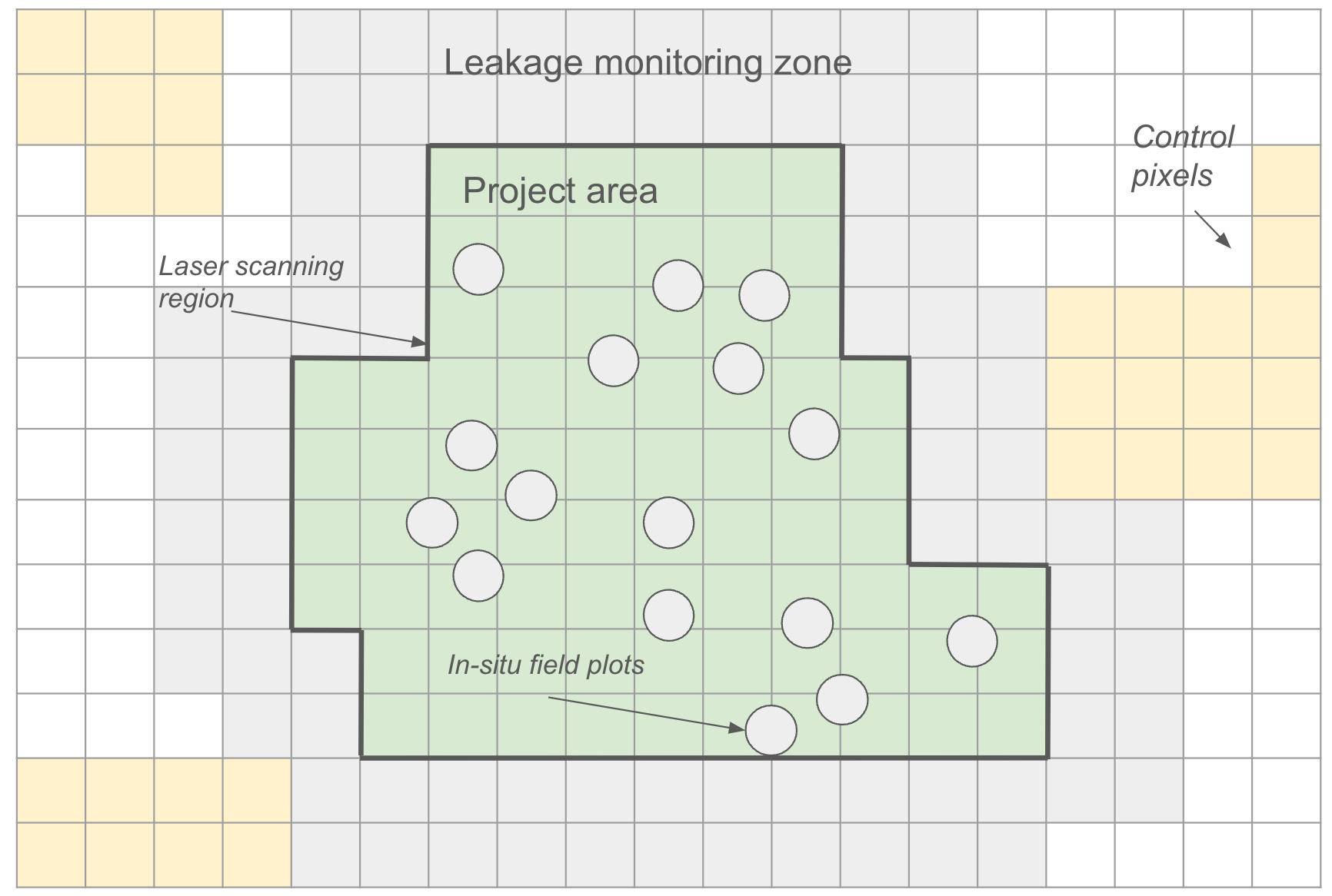
Figure 3. Schematic of the various monitoring locations referred to throughout this Protocol.
12.3
Project Area
The entire project area in Figure 3 must be monitored for the duration of the Project Commitment Period (see Section 5.1).
During the Crediting Period, monitored parameters from an AGB proxy map (e.g., canopy height) in the project area is used in conjunction with control pixels to establish a dynamic baseline for determining the additionality of carbon storage in the project area. Isometric will handle all aspects of the dynamic baseline assessment. Project Proponents are responsible for monitoring conducted within the Project Area that is required for the selected AGB quantification method (see Section 9.3.2).
After the Crediting Period, ongoing monitoring of forest biomass (e.g., forest cover or saturation index) must continue annually until the end of the Project Commitment Period for detection of Reversals (see Section 10.4). Isometric will ensure independent ongoing monitoring for Reversals until the end of the Project Commitment Period.
12.4
Control Pixels
Control pixels are used to assess natural regeneration in similar land areas outside the project area to determine the additional carbon storage of a reforestation project beyond the counterfactual scenario. Control pixels are selected by matching each project area pixel to a number of pixels outside the project area that historically behaved similarly (see Section 9.5.3).
An AGB proxy map (e.g., canopy height) is used to determine the relative difference in forest carbon between the Project and Counterfactual scenario for each Reporting Period. Isometric is responsible for the selection of control pixels and the calculation of the dynamic baseline (see Section 9.5).
12.5
Leakage Monitoring Zone
For projects without sufficient activity-shifting leakage mitigation, the Leakage Monitoring Zone must be monitored using satellite imagery for the duration of the Crediting Period to detect deforestation near the project area. Annual monitoring of forest cover over time is used to calculate deforestation rates over time. See Section 8.3.7 for more details on how leakage monitoring is used. Isometric is responsible for conducting any required leakage monitoring.
12.6
Laser Scanning Region
Airborne laser scanning measurements are only applicable for projects that wish to use regional LiDAR models to estimate AGB (details described in corresponding Module). ALS data collection should occur throughout the Crediting Period, at the end of each Reporting Period.
12.7
In situ Field Plots
In situ field measurements are required for all projects throughout the Crediting Period. Field plots may be used as the primary method for calculating aboveground biomass, or are used for benchmarking regional LiDAR-based or Earth Observation based AGB maps. Details of the application of these methodologies for AGB quantification are described in the corresponding Modules. For projects selecting the quantification approach where AGB is derived directly from field measurements, then in situ field plots must be sampled at the beginning and end of each Reporting Period. Otherwise, for both LiDAR approaches and Earth Observation based AGB maps, field measurements must be taken at a minimum of every 5 years for benchmarking purposes. At minimum, species identification and DBH must be measured for all trees with DBH > 10 cm within the in situ field plot.
12.7.1
Monitoring before First Verification
During the first few years after planting seedlings, there may not be many trees with DBH > 10 cm. However, it is still important to monitor field plots during this time as young forests are particularly vulnerable to disease, ecological hazards, and may experience high rates of mortality. In addition, techniques to quantify forest biomass tend to overestimate in young forests. Between project initiation and first Verification (see Section 5), it is recommended to monitor for early tree mortality every 6 months to better constrain early stage growth as well as inform any mortality mitigation activities (e.g., replanting trees).
12.8
Summary of Monitoring Requirements
Table 2 Summary of the required and recommended monitoring parameters.
Frequency | Location | Parameter | Methods | Justification | Recommended or Required | Responsible party |
|---|---|---|---|---|---|---|
From initial planting to first Verification, recommended every 6 months | In-situ field plots | Tree mortality | Mortality survey, or high resolution drone imagery | Estimations of forest biomass may be highly uncertain during the initial years after tree planting due to high rates of tree mortality and biases in young forests. Surveys for early tree mortality can better constrain early stage biomass growth, and enable mortality mitigation activities | Recommended | Project Proponent |
At the start and end of each Reporting Period for Area-Based AGB Quantification (see Module for details). Otherwise, at least every 5 years. | In situ field plots | DBH for all trees larger than 10 cm diameter | Tape measure | Fundamental measurement estimating AGB using allometric equations | Required | Project Proponent |
At the start and end of each Reporting Period for Area-Based AGB Quantification (see Module for details). Otherwise, at least every 5 years. | In situ field plots | Tree species | Ecologist identification | Necessary for selecting species-specific allometric equations and parameters | Required | Project Proponent |
As set out in the applicable Module | In situ field plots | Soil organic carbon and/or deadwood stocks | As set out in the Forest Soil Organic Carbon Quantification Module or the Deadwood Quantification Module | To quantify the optional pools in Equation 12 | Required where the pool is quantified, otherwise not applicable | Project Proponent |
At the start and end of each Reporting Period, e.g., once a year in the same season | Laser scanning plots | 3D Point clouds and derived metrics (e.g., canopy height) | Laser scanning instruments mounted on aerial platforms | To derive estimates of forest aboveground biomass | Required when LiDAR quantification Module selected, otherwise not applicable | Project Proponent |
At the start and end of each Reporting Period, e.g., once a year in the same season | Project area | AGB Map | Satellite data or third-party mapped product | To derive estimates of forest aboveground biomass | Required when the Earth Observation based AGB map quantification Module is selected, otherwise not applicable | Isometric or a third party |
At the start and end of each Reporting Period, e.g., once a year in the same season | Control pixels & project area | Forest carbon proxy (e.g, canopy height, biomass saturation index) | Satellite data or third-party mapped product | To quantify relative change in forest carbon sequestration between control pixels and project area (Equation 14) | Required | Isometric or a third party |
At the start and end of each Reporting Period, e.g., once a year in the same season | Leakage buffer zone | Indicators of deforestation | Satellite | To identify any activity-shifting leakage that should be taken into account for the net carbon removal calculation (Equation 9) | Required | Isometric or a third party |
Annually, for every complete year from the start of the Leakage Mitigation Site contract (for livestock, at the same census date each year) | Leakage Mitigation Site(s) | Productivity of the mitigated commodity (for livestock, herd inventory) | Production records (e.g., farm records, sales records, herd census) | To calculate MAP (Equations 3–5) and, for a shared Leakage Mitigation Site, the allocation of leakage mitigation emissions (Equations 6–8b). Records cannot be recreated after the fact. | Required where leakage mitigation is undertaken, otherwise not applicable | Project Proponent |
At each Verification | Project area | Area and planting date (or assisted natural regeneration start date) of each planting area | Planting records and shapefiles | To allocate Certificates to calendar-year vintages (Equation 1) | Required where Certificates are allocated by linear apportionment, otherwise not applicable | Project Proponent |
Each harvest event; forest management plan updated at each Verification | Project area | Harvest location, intensity and interval, and trees removed | Operational harvest records and forest management plan | To confirm harvesting does not reduce carbon stocks below those quantified at the most recent Verification, and to account for harvesting emissions (Section 4.2) | Required where harvesting of woody biomass takes place, otherwise not applicable | Project Proponent |
Each burn; reported at each Verification | Project area | Date, location and extent of each prescribed burn | Burn records under the fire management plan | To determine whether a burn reduced the carbon stock of a quantified pool (Section 10.2) | Required where prescribed fire is used, otherwise not applicable | Project Proponent |
From the end of the Crediting Period to the end of the Project Commitment Period, annually | Project area | Indicators of deforestation | Satellite | To identify Reversals and appropriately remediate through the Buffer Pool | Required | Isometric or a third party |
13.0
Acknowledgements
Isometric would like to thank the following external reviewers of this Protocol/Module:
- Jessica Hinojosa, Ph.D.
14.0
Definitions and Acronyms
- ActivityThe steps of a Project Proponent’s Removal or Reduction process that result in carbon fluxes. The carbon flux associated with an activity is a component of the Project Proponent’s Protocol.
- AdditionalityAn evaluation of the likelihood that an intervention—for example, a CDR Project—causes a climate benefit above and beyond what would have happened in a no-intervention Baseline scenario.
- AmortizationThe term used to describe allocation of Project emissions to multiple Removals or Reductions.
- BaselineA set of data describing pre-intervention or control conditions to be used as a reference scenario for comparison.
- Below Ground Biomass (BGB)The total mass of living woody biomass existing below the soil surface in a specified area.
- BiodiversityThe diversity of life across taxonomic and spatial scales. Biodiversity can be measured within species (i.e. genetic diversity and variations in allele frequencies across populations), between species (i.e. the total number and abundance of species within and across defined regions), within ecosystems (i.e. the variation in functional diversity, such as guilds, life-history traits, and food-webs), and between ecosystems (variation in the services of abiotic and biotic communities across large, landscape-level scales) that support ecoregions and biomes.
- Buffer PoolA common and recognized insurance mechanism among Registries allowing Certificates to be set aside (in this case by Isometric) to compensate for Reversals which may occur in the future.
- BuyerAn entity that purchases Removals, Reductions, or Environmental Attributes, often with the purpose of Retiring Certificates to make a Removal, Reduction, or Environmental Attribute claim.
- Carbon Dioxide Equivalent Emissions (CO₂e)The amount of CO₂ emissions that would cause the same integrated radiative forcing or temperature change, over a given time horizon, as an emitted amount of GHG or a mixture of GHGs. One common metric of CO₂e is the 100-year Global Warming Potential.
- Carbon Dioxide Removal (CDR)Activities that remove carbon dioxide (CO₂) from the atmosphere and store it in products or geological, terrestrial, and oceanic Reservoirs. CDR includes the enhancement of biological or geochemical sinks and direct air capture (DAC) and storage, but excludes natural CO₂ uptake not directly caused by human intervention.
- Carbon FinanceResources provided to projects that are generating, or are expected to generate, greenhouse gas (GHG) Emission Reductions or Removals.
- CertificateA publicly visible, uniquely identifiable, Verified instrument Issued on the Isometric Registry. Isometric Issues three Certificate Types: Carbon Dioxide Removal Certificates, Emission Reduction Certificates and Environmental Attribute Certificates.
- CommodityA product that has been cultivated, raised or harvested primarily for food, shelter, or natural fiber.
- ConservativePurposefully erring on the side of caution under conditions of Uncertainty by choosing input parameter values that will result in a lower net CO₂ Removal or GHG Reduction than if using the median input values. This is done to increase the likelihood that a given Removal or Reduction calculation is an underestimation rather than an overestimation.
- CounterfactualAn assessment of what would have happened in the absence of a particular intervention – i.e., assuming the Baseline scenario.
- Cradle-to-GraveConsidering impacts at each stage of a product's life cycle, from the time natural resources are extracted from the ground and processed through each subsequent stage of manufacturing, transportation, product use, and ultimately, disposal.
- Crediting PeriodThe period of time over which a Project Design Document is valid, and over which Removals, Reductions or Environmental Attributes may be Verified, resulting in Issued Certificates.
- DeliveryThe outcome of a Project Proponent providing Certificates to fulfill Buyers' purchases.
- Direct ActorsSite owners, tenants or other users that engaged with the Project site in a way that produced commodities before project activities started.
- Double CountingImproperly allocating the same Removal or Reduction from a Project Proponent more than once to multiple Buyers.
- DurabilityThe amount of time carbon removed from the atmosphere by an intervention – for example, a CDR project – is expected to reside in a given Reservoir, taking into account both physical risks and socioeconomic constructs (such as contracts) to protect the Reservoir in question.
- Dynamic BaseliningA method for establishing and regularly updating the reference carbon stock levels in a reforestation project area, based on ongoing analysis of comparable non-project plots, to account for natural fluctuations and improve the accuracy of carbon Certificate calculations over the project lifetime.
- Ecological IntegrityThe ability of an ecosystem to support and maintain ecological processes and a diverse community of organisms. It is measured as the degree to which a diverse community of native organisms is maintained, and is used as a proxy for ecological resilience, intended as the capacity of an ecosystem to adapt in the face of stressors, while maintaining the functions of interest.
- Ecosystem FunctionThe natural processes and interactions that occur within an ecosystem, including the flow of energy and materials through biotic and abiotic components, encompassing activities like nutrient cycling, primary production, and habitat provision, which collectively maintain the balance and stability of the ecosystem.
- Embodied EmissionsLife cycle GHG emissions associated with production of materials, transportation, and construction or other processes for goods or buildings.
- Emission ReductionsLowering future GHG releases from a specific entity.
- EmissionsThe term used to describe greenhouse gas emissions to the atmosphere as a result of Project activities.
- Ex-post CreditsIssuance of Credits after removal or reduction took place. This is the manner in which Isometric Delivers Credits.
- GHG StatementA document submitted alongside Claimed Removals and/or Reductions that details the calculations associated with a Removal or Reduction, including the Project's emissions, Removals, Reductions and Leakages, presented together in net metric tonnes of CO₂e per Removal or Reduction.
- Global Positioning System (GPS)A satellite-based navigation system.
- Greenhouse Gas (GHG)Those gaseous constituents of the atmosphere, both natural and anthropogenic (human-caused), that absorb and emit radiation at specific wavelengths within the spectrum of terrestrial radiation emitted by the Earth’s surface, by the atmosphere itself, and by clouds. This property causes the greenhouse effect, whereby heat is trapped in Earth’s atmosphere (CDR Primer, 2022).
- International Standards Organization (ISO)A worldwide federation (NGO) of national standards bodies from more than 160 countries, one from each member country.
- Invasive SpeciesA species whose introduction, spread, and/or growth threatens biological diversity.
- Issuance (of a Certificate)Certificates are issued to the Certificate Account of a Project Proponent with whom Isometric has a Validated Protocol after an Order for Verification and Certificate Issuance services from a Buyer and once a Verified Removal or Reduction has taken place.
- LeakageThe increase in GHG emissions outside the geographic or temporal boundary of a project that results from that project's activities.
- Leakage Mitigation Site (LMS)An area separate from the Project site where the Project Proponent increases production of a displaced commodity to mitigate leakage (Section 8.3.3).
- Leakage Monitoring ZoneA transitional or boundary zone along the Project’s perimeter that is monitored for activity-shifting leakage.
- Light Detection and Ranging (LiDAR)LiDAR is a remote sensing technology that uses laser pulses to create highly accurate three-dimensional maps of forest structure, enabling measurements of tree height, canopy density, and biomass.
- Lossesfor open systems, biogeochemical and/or physical interactions which occur during the removal process that decrease the CO₂ removal .
- MaterialityAn acceptable difference between reported Removals/emissions or Reductions/emissions and what an auditor determines is the actual Removal/emissions or Reduction/emissions.
- ModelA calculation, series of calculations or simulations that use input variables in order to generate values for variables of interest that are not directly measured.
- ProjectAn activity or process or group of activities or processes that alter the condition of a Baseline and leads to Removals or Reductions.
- Project Design DocumentThe document, written by a Project Proponent, which records key characteristics of a Project and which forms the basis for Project Validation and evaluation in accordance with the relevant Certified Protocol. (Also known as “PDD”).
- Project Design Document (PDD)The document that clearly outlines how a Project will generate rigorously quantifiable Additional high-quality Removals or Reductions.
- Project ProponentThe organization that develops and/or has overall legal ownership or control of a Removal or Reduction Project.
- Project boundaryThe defined temporal and geographical boundary of a Project.
- ProtocolA document that describes how to quantitatively assess the net amount of CO₂ removed by a process. To Isometric, a Protocol is specific to a Project Proponent's process and comprised of Modules representing the Carbon Fluxes involved in the CDR process. A Protocol measures the full carbon impact of a process against the Baseline of it not occurring.
- ProxyA measurement which correlates with but is not a direct measurement of the variable of interest.
- RegistryA database that holds information on Verified Removals and Reductions, and reviewed EACs, based on Protocols. Registries Issue Certificates, and track their ownership and Retirement.
- Remote SensingThe use of satellite, aircraft and terrestrial deployed sensors to detect and measure characteristics of the Earth's surface, as well as the spectral, spatial and temporal analysis of this data to estimate biomass and biomass change.
- RemovalThe term used to represent the CO₂ taken out of the atmosphere as a result of a CDR process.
- Reputable SourceA source that would be widely considered trustworthy based on the process undertaken (e.g., peer review) or origin of the information (e.g., government body).
- ReservoirA location where carbon is stored. This can be via physical barriers (such as geological formations) or through partitioning based on chemical or biological processes (such as mineralization or photosynthesis).
- ReversalThe escape of CO₂ to the atmosphere after it has been stored, and after a Certificate has been Issued. A Reversal is classified as avoidable if a Project Proponent has influence or control over it and it likely could have been averted through application of reasonable risk mitigation measures. Any other Reversals will be classified as unavoidable.
- SSRsSources, Sinks and Reservoirs
- SinkAny process, activity, or mechanism that removes a greenhouse gas, a precursor to a greenhouse gas, or an aerosol from the atmosphere.
- SourceAny process or activity that releases a greenhouse gas, an aerosol, or a precursor of a greenhouse gas into the atmosphere.
- StakeholderAny person or entity who can potentially affect or be affected by Isometric or an individual Project activity.
- StorageDescribes the addition of carbon dioxide removed from the atmosphere to a reservoir, which serves as its ultimate destination. This is also referred to as “sequestration”.
- Synthetic Aperture Radar (SAR)A remote sensing technology which uses radio waves to create images of the earth’s surface.
- System BoundaryGHG sources, sinks and reservoirs (SSRs) associated with the project boundary and included in the GHG Statement.
- UncertaintyA lack of knowledge of the exact greenhouse gas impact (removal, reduction, or avoidance) associated with a particular process or Environmental Attribute. Uncertainty may be quantified using probability distributions, confidence intervals, or variance estimates.
- Validation and Verification Bodies (VVBs)Third-party auditing organizations that are experts in their sector and used to determine if a project conforms to the rules, regulations, and standards set out by a governing body. A VVB must be approved by Isometric prior to conducting validation and verification.
15.0
Appendix A: Commodity Classifications for Leakage Mitigation
This Appendix defines the commodity classes used in Sections 8.3.3.1 and 8.3.3.2. Classes 1–9 follow the FAO (2010) World Programme for the Census of Agriculture crop classification, which groups crops by agricultural use. A commodity is classified by what is sold or consumed, not by the land cover it grows on. For example, beef from cattle on pasture is Livestock, not "grasses and fodder crops". Classes 10 and 11 cover livestock and dairy, which the FAO crop classification does not.
Table A1
No. | Commodity class | Example commodities |
|---|---|---|
1 | Cereals | Wheat, maize, rice, sorghum, barley, rye, oats, millets, other cereals |
2 | Vegetables and melons | Leafy or stem vegetables (cabbage, lettuce); fruit-bearing vegetables (tomato, melon, pumpkin); root, bulb and tuberous vegetables (carrot, onion); mushrooms and truffles |
3 | Fruit and nuts | Tropical and subtropical fruits, citrus, grapes, berries, pome and stone fruits, nuts |
4 | Oilseed crops | Soybeans, groundnuts, rapeseed, sunflower, safflower, sesame, mustard, linseed, castor, coconuts, olives, oil palms |
5 | Root and tuber crops | Potatoes, sweet potatoes, cassava, yams |
6 | Beverage and spice crops | Coffee, tea, maté, cocoa; spices such as chillies, pepper, cinnamon, cloves, ginger, vanilla |
7 | Leguminous crops | Beans, broad beans, chickpeas, cowpeas, lentils, lupins, peas, pigeon peas |
8 | Sugar crops | Sugar beet, sugar cane, sweet sorghum |
9 | Other crops | Grasses and fodder crops sold as a commodity; fibre crops (cotton, jute, flax, hemp); medicinal and aromatic crops; rubber; flowers; tobacco |
10 | Livestock | Cattle, buffalo, sheep, goats, pigs and poultry raised for meat |
11 | Dairy | Milk from cattle, buffalo, goats and sheep |
Source: FAO (2010), A System of Integrated Agricultural Censuses and Surveys: World Programme for the Census of Agriculture 2010, Appendix 3.
16.0
Appendix B: Net Climate Impact Thresholds
When assessing the net climate impact (NCI) within the Project Area using the data from Hasler et al. (2024)9, the threshold for determining whether an area is net climate negative should use the biome-specific uncertainty values shown in Table B1 which are derived from Table S2 of the study. The uncertainty value for a given biome is taken from the range of values yielded from different parameterizations used in the study. Areas will be considered to be net climate negative, and therefore ineligible for planting, when their NCI Density value plus biome specific uncertainty is less than zero. For example, for temperate broadleaf and mixed forests, any areas with NCI densities less than -31 Mg ha will be considered net climate negative.
Table B1. Net Climate Impact (NCI) Density [Mg ha] Biome-Specific Uncertainty.
Biome | Mean NCI Density | Min NCI Density | Max NCI Density | Uncertainty (+/-) |
|---|---|---|---|---|
Tundra | -110 | -190 | -41 | 74.5 |
Boreal Forests/Taiga | 42 | 0 | 85 | 42.5 |
Temperate Grasslands, Savannas & Shrublands | -98 | -138 | -56 | 41 |
Mediterranean Forests, Woodlands & Scrub | -92 | -135 | -65 | 35 |
Temperate Conifer Forests | 156 | 110 | 196 | 43 |
Temperate Broadleaf & Mixed Forests | 182 | 147 | 209 | 31 |
Tropical & Subtropical Grasslands, Savannas, & Shrublands | 39 | -15 | 70 | 42.5 |
Tropical & Subtropical Coniferous Forests | 250 | 235 | 260 | 12.5 |
Tropical & Subtropical Dry Broadleaf Forests | 203 | 179 | 216 | 18.5 |
Tropical & Subtropical Moist Broadleaf Forests | 598 | 588 | 605 | 8.5 |
Mangroves | 527 | 519 | 532 | 6.5 |
Flooded Grasslands & Savannas | 91 | 65 | 108 | 21.5 |
Montane Grasslands and Shrublands | -233 | -315 | -188 | 63.5 |
Deserts & Xeric Shrublands | -205 | -250 | -171 | 39.5 |
Globally | 120 | 80 | 150 | 35 |
17.0
Appendix C: Recommended Datasets and Resources
17.1
Allometry and Root-to-shoot Ratios
It is recommended to make use of root-to-shoot ratios that are developed in tandem with the allometry used. Allometric equations and root-to-shoot ratios should be selected based on the following hierarchy:
- Equations developed for national forest inventories
- IPCC generalized equations for different forest types
- Local peer-reviewed equations
For example in the United States, the National Scale Volume Biomass (NSVB) equations can be used, and these equations come with root allometry. The framework is explained in A national-scale tree volume, biomass, and carbon modeling system for the United States38 and the coefficients are given in the supplementary materials.
Furthermore, Allometric is an R package that curates allometric equations and facilitates their usage.
17.2
Land Cover Fraction
Datasets with the following characteristics will generally provide stronger evidence: peer-reviewed with publicly available data and code; classification accuracy > 90% with reported uncertainty; spatial resolution ≤ 30 m; and annual data for at least the 10 years prior to project initiation.
- Copernicus Global Land Cover Layers: CGLS-LC100 Collection 3 39 gives 100 m estimates of land cover fraction derived from Proba-V multispectral imagery and supplemental covariates.
- The ESA WorldCover 10 m is a discrete, and not fractional, product developed using Sentinel-1 radar and Sentinel-2 multispectral data40.
- Dynamic World is a 10 m, near-real time land use land cover layer produced by Google and distributed via Google Earth Engine. Note that this product is often best aggregated across a larger time-period for optimal accuracy41.
- Impact Observatory offers a free 10 m annual land cover layer based on Sentinel-2 multispectral data42.
18.0
Appendix D: Future Improvements
Additionality
- Currently, this Protocol uses a project-specific performance benchmark against control pixels to determine additionality. Future versions of the Protocol may explore using remote sensing data to further create performance benchmarks to assess financial and regulatory additionality of the Project.
Approved Resources and Third-Party Datasets
- Isometric will develop and maintain a list of approved resources and third-party datasets for various parameters (e.g., carbon fractions, land cover classification maps, risk assessment) for different regions and biomes. Isometric will use this list for all relevant in-house monitoring processes, and Project Proponents must choose resources from this list unless they provide reasonable justification for a deviation (e.g., a new peer-reviewed publication that advances local knowledge).
Albedo
- Currently, albedo effects are not quantified since projects cannot be located in regions where albedo changes result in net warming. Incorporation of albedo impacts into this Protocol will be regularly reviewed.
Baseline
- Prior research on dynamic baselines have mostly been in the context of REDD+ and not reforestation. The methods for pixel matching routines, statistical criteria and uncertainty in this Protocol will be revisited regularly and updated as necessary to reflect the best available scientific knowledge, as well as any developments in relevant government policies or legal requirements. At a minimum, reviews will occur every two years.
Buffer Pool Contribution
- Isometric will review and adapt third-party tools and datasets, such as buffer pool density maps, as they become publicly available to enable project- and site-specific determination. Buffer Pools will be reassessed and scaled as appropriate to account for risk amplification or mitigation due to management activities and climate change.
Insurance
- Insurance providers can provide a third party risk assessment, are financially incentivized to correctly price risk, and have a fiduciary responsibility to pay out in the event of a Reversal. This version of the Protocol introduces insurance as a pilot (Section 10.3.4). In the pilot, insurance covers part of the Reversal risk in the early years of crediting, while Buffer Pool contributions build up to the level the Project would have reached without insurance. Isometric will review the pilot’s results before extending or changing it in future versions.
Quantification with LiDAR
- Terrestrial laser scanning systems offer promise in quantifying forest biomass. Guidance on requirements and best practices for the use of terrestrial laser scanning and are being considered for future versions of this Protocol.
- Individual tree crown (ITC) modeling is an alternative quantification approach. Detailed requirements for ITC modeling, LiDAR data used for ITC and allowable errors, will be considered for future versions of this Protocol.
Leakage
- Future versions may involve more reliance on leakage mitigation and eligibility requirements and possible removal of the leakage discounting.
- Currently, the Protocol assumes ecological leakage is zero. This will be revisited in future updates and included, where appropriate, in leakage assessment and leakage mitigation, especially in relation to areas sensitive to disease.
- Future versions of this Protocol may consider other land use activity-shifting leakages beyond deforestation.
- Future revisions of this Protocol will consider appropriate requirements for remote sensing data used for determining productivity.
Leakage Mitigation
- ‘Within project’ mitigation, such as timber harvesting, may be included in future Modules.
Stakeholder Engagement
- More detailed guidance on stakeholder identification and differentiation will be considered for future versions of the Protocol.
- Additional guidance on due diligence required to demonstrate that stakeholder rights are upheld will be considered for future versions of the Protocol.
Uncertainty
- Project Proponents are expected to quantify and justify the uncertainty associated with each parameter in the carbon removal calculation.
- Additional guidance on model validation metrics will be considered for future improvements.
- Isometric will consider providing a case study of uncertainty propagation for forest carbon stock quantification.
Emergency Response
- Isometric may develop further guidelines on emergency response planning for disease, illegal logging, and forest fires.
19.0
Appendix E: Reforestation Risk Assessment
G-22TX-0
The Reforestation Risk Assessment is used to assess the overall delivery and storage risk associated with reforestation and may inform the Buffer Pool contribution during Certificate delivery (see Section 10.3). The assessment must first be filled in by the Project Proponent and must be validated by a VVB. During project Validation, discrepancies between the Project Proponent’s self reported score and VVB may result in monitoring or risk mitigation activities, or project ineligibility. Eligible projects must have an initial risk score ≤ 20 and initial risk category scores at or below the following thresholds:
- Project Proponent Capacity Risk ≤ 7
- Financial Viability Risk ≤ 8
- Social Governance Risk ≤ 11
- Disturbance Risk ≤ 13
All risk categories shall have a minimum score of 0, regardless of the outcome of the Reforestation Risk Assessment.
For projects with discrete planting areas, the risk assessment must include all geographic areas relevant to the Project. For risk indicators that are geographically explicit (e.g., disturbance risks), the score may be calculated via an area-weighted average and rounded up to the nearest whole number.
The Covered under insurance pilot column in Table E1 identifies the indicators whose peril may be covered by an approved policy under the insurance pilot (Section 10.3.4). Core and enhanced cover are defined in Isometric’s Insurance Framework. Eligibility is always assessed on the full Reforestation Risk Assessment against the cutoffs above.
If Project Proponents choose to forgo a flat 20% Buffer Pool contribution (see Section 10.3.1), the Reforestation Risk Assessment will inform Buffer Pool contributions for the Project according to the process outlined in Appendix G for each Reporting Period and in accordance with the requirements in Section 10.2.
- After each new Reforestation Risk Assessment evaluation, Isometric will update the required percentage of newly issued Certificates that must be contributed to the Buffer Pool by the Project. We encourage Project Proponents to continuously monitor, mitigate, and reduce risks.
Table E1. Reforestation Risk Assessment, with the score to be filled out for each question. Where a scoring guideline lists lettered options, select the single option that applies.
Risk Category | Risk Indicator | Evidence | Scoring Guidelines | Covered under insurance pilot | Score |
|---|---|---|---|---|---|
Project Proponent Capacity Risk | Does the Project Proponent maintain staff with domain expertise relevant for forest carbon projects? (e.g., forest ecology, forest measurement, carbon accounting) | Project’s team structure | If no, describe how gaps in relevant expertise will be filled, +1. | No | |
Does the Project Proponent maintain a staff presence in the local vicinity (within one day of travel) of the Project site? | Project’s team structure | If no, +2. | No | ||
Was the Project Proponent established more than 12 months ago? | Project Proponent declaration | If no, +1. | No | ||
Does the Project Proponent have prior experience in ecosystem restoration, carbon projects or planting? | Review of Project Proponent provided evidence and independent research | If yes, -1. | No | ||
Has the Project Proponent abandoned or failed previous projects? | Review of projects on other registries | If yes, +3. | No | ||
What proportion of the project area requires active enforcement against external threats (e.g., illegal logging, agricultural encroachment, unauthorized grazing) to protect carbon stocks? | Peer-reviewed publications, local or national government databases, NGO reports and assessments, site security assessment, satellite data, data on enforcement from other reforestation projects in the same region, local or national reports on environmental crimes or violations |
| Enhanced cover only | ||
Financial Viability Risk | Has the Project secured funding to cover all activities required before carbon revenue accrues? | Project financial plan |
| No | |
What is the projected time to reach financial breakeven? | Project financial plan |
| No | ||
Is the budget reasonable given the proposed project activities and ex-ante estimates for forest growth? Budget should at minimum include: personnel, equipment and supplies, infrastructure, travel and certification fees. | Project financial plan | If no, +2. | No | ||
Does the Project financial plan demonstrate sufficient cash flow throughout the Ongoing Monitoring Period to maintain forest carbon stocks? | Project financial plan | If continued financial incentive is low compared to likely opportunity cost of harvest, +2. | No | ||
Does the Project financial plan rely on future increases in market price for Carbon Certificates? | Project financial plan | If yes, +1. | No | ||
Social Governance Risk | Are there currently or have there been disputes over land ownership over the last 20 years? | Jurisdictional history | If yes, +2. | No | |
Does the government have a history within the past 50 years of revoking legal agreements regarding land ownership, access, and usage? | Jurisdictional history | If yes, +2. | No | ||
Does the Project host country have a 10-year average score below 40 on 3 or more of the Worldwide Governance Indicators? (See the note below Table E1.) | If yes, +2. | No | |||
Does the government have an NDC in place that addresses corresponding adjustments/prevents double-counting of project Credits and NDC contributions? | National registries | If no, +1. | No | ||
Does the Project have a detailed benefit-sharing plan that includes: clear distribution mechanisms, transparent criteria for beneficiary selection, a grievance resolution process, monitoring and reporting procedures? (See the note below Table E1.) | Project financial plan, benefit-sharing agreements, and stakeholder engagement records (see Section 6.5.1) | Select one: A. No benefit-sharing plan, +2. B. Plan is missing one or more elements, +1. C. Plan includes all elements but is neither legally binding nor audited by a third party, 0. D. Plan includes all elements and is legally binding, -1. E. Plan includes all elements and is audited by a third party, -1. F. Plan includes all elements and is both legally binding and audited by a third party, -2. | No | ||
Does the Project Proponent have a presence on human rights, environmental or labor infraction lists? | National registries | If yes, fail. | No | ||
Does the Project Proponent have ongoing legal disputes? | National registries | If yes, +1. | No | ||
Does the Project Proponent have a presence in negative press content? | Online search | If yes, +1. | No | ||
Has the Project Proponent assessed whether the project area overlaps Indigenous or community lands (see Section 6.5.1)? | Indigenous Peoples assessment (Section 6.5.1); cross-reference of project documentation with Global Forest Watch | If no, fail. | No | ||
Are baseline activities primarily subsistence-driven? | Land use documentation, Socioeconomic surveys |
| No | ||
(a) Are there anticipated or demonstrated net positive community impacts? | Community impact assessment, project financial plan, socio-economic surveys | If no, +2. | No | ||
(b) What is the net present value (NPV) of alternative land use compared to project NPV? | NPV analysis comparing alternative uses to project activities over Crediting Period, price forecasts, discount rate justification |
| No | ||
Are opportunity cost risk mitigations in place? | Legal agreements protecting carbon stocks, Non-profit status documentation, grant/funding agreements | Select one: A. No mitigations in place, 0. B. Carbon stocks legally protected for the Crediting Period, but for less than 100 years, -1. C. Carbon stocks legally protected for 100 years or more, -2. D. Non-profit status or secured additional funding, -1. E. Both B and D, -2. F. Both C and D, -3. | No | ||
Disturbance Risk | Fire risk | Mean daily Global Fire Weather Index over the prior two years |
| Core and enhanced cover | |
Pest and disease outbreak risk | Regional third-party maps, if available. |
| Core and enhanced cover | ||
Extreme weather (temperature - heat and cold) | IPCC AR6 43 - See Appendix F for scoring |
| Core and enhanced cover | ||
Extreme weather (hydrologic - flood and drought) | IPCC AR6 43 - See Appendix F for scoring |
| Core and enhanced cover | ||
Coastal risks (sea level rise, storm surge, tropical cyclones, salinity intrusion) | Regional third-party maps, if available. |
| Core and enhanced cover | ||
Geologic risks (earthquakes, tsunami, volcanoes) | If historical hazards in area, +1. | Core and enhanced cover | |||
Illegal timber risk |
| Enhanced cover only | |||
Surrounding anthropogenic activities pose environmental risk (e.g., toxic pollution, industrial farming, new developments etc.) | Satellite imagery, site visit | If yes, +1. | Enhanced cover only | ||
Ecological Resilience | Project Design Document | Select one: A. Neither B nor C applies, 0. B. 10+ species from 4+ genera planted, -1. C. More than 80% of trees planted are heat or drought tolerant, -1. D. Both B and C apply, -2. | Core and enhanced cover | ||
Flood plain hazards | Project area overlap with identified floodplain based on Nardi et al., 2019 44 or regional/local equivalent |
| Core and enhanced cover |
Benefit-sharing plan. For the benefit-sharing indicator in Table E1, benefits may take any form, including monetary payments, goods, services, employment, infrastructure, training, or access to or a share of non-timber forest products. A benefit counts towards this indicator where:
- the stakeholder engagement process described in Section 6.5.1 demonstrates that the benefit is wanted by the community or stakeholder group receiving it; and
- the benefit is distributed and tracked through the benefit-sharing plan. Evidence that a benefit was identified through stakeholder engagement may include meeting records, consultation summaries, or written requests from the community or stakeholder group.
Worldwide Governance Indicators. Scores refer to the World Bank's Worldwide Governance Indicators governance scores on the absolute 0–100 scale introduced in the 2025 revision. For each of the six indicators, the score is averaged over the 10 most recent years of published data at the time of the assessment. The indicator scores +2 where three or more of the six indicators have a 10-year average below 40.
20.0
Appendix F: Calculating Extreme Weather Risk Scores
The following section outlines how Isometric calculates the indicator scores for climate-related extreme weather disturbance risks to carbon permanence within a project’s region (Figure F1). Project Proponents should use Table F1 to lookup the Isometric-calculated values for their project's region and include those scores in their Reforestation Risk Assessment (see Appendix E).
Extreme weather risks are assessed via two indicators: a temperature indicator (extreme heat and/or cold) and a hydrologic indicator (flooding and/or drought). Each indicator includes both historical data (1961-2015) and projected future extreme events. Historical data indicate the likelihood of extreme events based on past climate patterns, e.g., projects in regions with extended dry periods are expected to experience increased water stress as part of their typical climate. Climate model projections describe how changing climate conditions, relative to historical patterns, might present an increased risk of disturbances. Areas where there is a larger shift towards extreme conditions under future climate relative to their historical baseline have a greater disturbance risk (e.g., drier conditions relative to historical averages increases risk for drought-driven mortality).
To calculate the scores in Table F1, Isometric uses values from the Intergovernmental Panel on Climate Change AR6 report43. The temperature indicator is calculated using data describing the annual number of frost days (, minimum temperature below 0°C) and annual number of days with a maximum temperature above 40°C () to capture extreme cold and extreme heat risks, respectively. The hydrologic indicator is calculated using data describing the maximum 5-day precipitation () and annual maximum number of consecutive dry days () to capture risks of flooding and drought, respectively. All values come from the CMIP6 climate models. Future projections use the SSP2-4.5 medium term (2041-2060) scenario and are assessed as the change in value relative to a historical baseline (1961-1990).
For each indicator subcomponent, the region’s terrestrial median value is compared with the global terrestrial distribution of the same variable (Table F2). To convert the regional value into a subscore, regional values below the global 50th percentile are considered Low Risk, regional values equal to or greater than the global 50th percentile but below the 75th percentile are Medium Risk, and any regional values equal to or greater than the global 75th percentile are High Risk. Low Risks are given a subscore of 0, Medium Risks are 0.25, and High Risks are 0.5. The overall score for each of the indicators is calculated by summing the corresponding subscores, as described below:
Projected change in the number of frost days is not included as a subcomponent since it is projected that they will decline under future climate across the globe, representing a low risk of future extreme cold events.
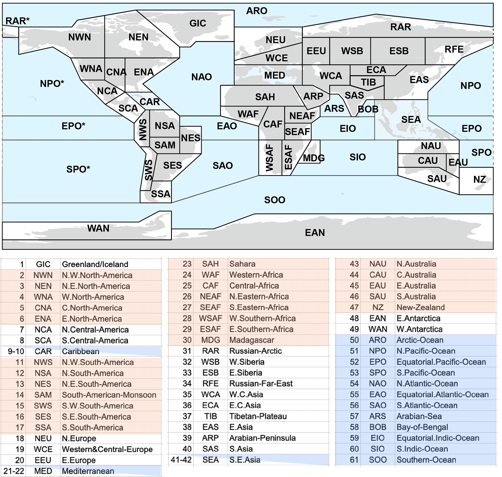
Figure F1. Map and lookup table for IPCC regional codes
Table F1. Regional Lookup Table of Disturbance Risk
Region | Indicator | Variable | Time | Value | Risk | Score | Total |
|---|---|---|---|---|---|---|---|
NW North America (NWN) | Temperature | Frost Days | Historical | 224.2 | High | 0.5 | 0.5 |
Days > 40°C | Historical | 0 | Low | 0 | |||
Change (Days) | 0 | Low | 0 | ||||
Hydrological | CDD | Historical | 23.5 | Low | 0 | 0.5 | |
Change (Days) | -1.4 | Low | 0 | ||||
5-Day Precip | Historical | 54.4 | Low | 0 | |||
Change (%) | 11.9 | High | 0.5 | ||||
NE North America (NEN) | Temperature | Frost Days | Historical | 242.9 | High | 0.5 | 0.5 |
Days > 40°C | Historical | 0 | Low | 0 | |||
Change (Days) | 0 | Low | 0 | ||||
Hydrological | CDD | Historical | 25.1 | Low | 0 | 0.5 | |
Change (Days) | -2.7 | Low | 0 | ||||
5-Day Precip | Historical | 50.6 | Low | 0 | |||
Change (%) | 11.8 | High | 0.5 | ||||
Western North America (WNA) | Temperature | Frost Days | Historical | 128.4 | High | 0.5 | 0.5 |
Days > 40°C | Historical | 0.9 | Low | 0 | |||
Change (Days) | 2 | Low | 0 | ||||
Hydrological | CDD | Historical | 40.6 | Low | 0 | 0 | |
Change (Days) | -0.2 | Low | 0 | ||||
5-Day Precip | Historical | 67.3 | Low | 0 | |||
Change (%) | 5.5 | Low | 0 | ||||
Central North America (CNA) | Temperature | Frost Days | Historical | 104.9 | High | 0.5 | 0.5 |
Days > 40°C | Historical | 4.7 | Low | 0 | |||
Change (Days) | 8.9 | Low | 0 | ||||
Hydrological | CDD | Historical | 23.7 | Low | 0 | 0.25 | |
Change (Days) | -0.4 | Low | 0 | ||||
5-Day Precip | Historical | 84.3 | Medium | 0.25 | |||
Change (%) | 6.7 | Low | 0 | ||||
Eastern North America (ENA) | Temperature | Frost Days | Historical | 116 | High | 0.5 | 0.5 |
Days > 40°C | Historical | 0.1 | Low | 0 | |||
Change (Days) | 0.6 | Low | 0 | ||||
Hydrological | CDD | Historical | 15.5 | Low | 0 | 0.75 | |
Change (Days) | -0.3 | Low | 0 | ||||
5-Day Precip | Historical | 89.4 | High | 0.5 | |||
Change (%) | 9 | Medium | 0.25 | ||||
Northern Central America (NCA) | Temperature | Frost Days | Historical | 15.9 | Low | 0 | 0 |
Days > 40°C | Historical | 4.7 | Low | 0 | |||
Change (Days) | 8.7 | Low | 0 | ||||
Hydrological | CDD | Historical | 51.6 | Low | 0 | 0.5 | |
Change (Days) | -0.2 | Low | 0 | ||||
5-Day Precip | Historical | 92.9 | High | 0.5 | |||
Change (%) | 6 | Low | 0 | ||||
Southern Central America (SCA) | Temperature | Frost Days | Historical | 0.1 | Low | 0 | 0 |
Days > 40°C | Historical | 0.5 | Low | 0 | |||
Change (Days) | 1.7 | Low | 0 | ||||
Hydrological | CDD | Historical | 39.7 | Low | 0 | 0.5 | |
Change (Days) | -1.6 | Low | 0 | ||||
5-Day Precip | Historical | 134.3 | High | 0.5 | |||
Change (%) | 4.3 | Low | 0 | ||||
Caribbean (CAR) | Temperature | Frost Days | Historical | 0 | Low | 0 | 0 |
Days > 40°C | Historical | 0 | Low | 0 | |||
Change (Days) | 0 | Low | 0 | ||||
Hydrological | CDD | Historical | 24.3 | Low | 0 | 0.5 | |
Change (Days) | 0.1 | Low | 0 | ||||
5-Day Precip | Historical | 99.9 | High | 0.5 | |||
Change (%) | 0.8 | Low | 0 | ||||
NW South America (NWS) | Temperature | Frost Days | Historical | 0.6 | Low | 0 | 0 |
Days > 40°C | Historical | 0.1 | Low | 0 | |||
Change (Days) | 0.8 | Low | 0 | ||||
Hydrological | CDD | Historical | 28.6 | Low | 0 | 0.5 | |
Change (Days) | -0.2 | Low | 0 | ||||
5-Day Precip | Historical | 133 | High | 0.5 | |||
Change (%) | 7.5 | Low | 0 | ||||
Northern South America (NSA) | Temperature | Frost Days | Historical | 0 | Low | 0 | 0 |
Days > 40°C | Historical | 0.5 | Low | 0 | |||
Change (Days) | 9.4 | Low | 0 | ||||
Hydrological | CDD | Historical | 46.7 | Low | 0 | 1 | |
Change (Days) | 9.7 | High | 0.5 | ||||
5-Day Precip | Historical | 111.6 | High | 0.5 | |||
Change (%) | 5.5 | Low | 0 | ||||
NE South America (NES) | Temperature | Frost Days | Historical | 0 | Low | 0 | 0 |
Days > 40°C | Historical | 0.3 | Low | 0 | |||
Change (Days) | 4.4 | Low | 0 | ||||
Hydrological | CDD | Historical | 95 | High | 0.5 | 1.5 | |
Change (Days) | 6.3 | High | 0.5 | ||||
5-Day Precip | Historical | 144.3 | High | 0.5 | |||
Change (%) | 5.7 | Low | 0 | ||||
South America-Monsoon (SAM) | Temperature | Frost Days | Historical | 7.5 | Low | 0 | 0.25 |
Days > 40°C | Historical | 2.2 | Low | 0 | |||
Change (Days) | 11.5 | Medium | 0.25 | ||||
Hydrological | CDD | Historical | 64.8 | Medium | 0.25 | 1.25 | |
Change (Days) | 13.7 | High | 0.5 | ||||
5-Day Precip | Historical | 133.7 | High | 0.5 | |||
Change (%) | 6 | Low | 0 | ||||
SW South America (SWS) | Temperature | Frost Days | Historical | 35.8 | Low | 0 | 0 |
Days > 40°C | Historical | 0 | Low | 0 | |||
Change (Days) | 0 | Low | 0 | ||||
Hydrological | CDD | Historical | 65.9 | Medium | 0.25 | 0.5 | |
Change (Days) | -4.2 | Low | 0 | ||||
5-Day Precip | Historical | 83 | Medium | 0.25 | |||
Change (%) | -0.9 | Low | 0 | ||||
SE South America (SES) | Temperature | Frost Days | Historical | 16.6 | Low | 0 | 0 |
Days > 40°C | Historical | 2.8 | Low | 0 | |||
Change (Days) | 5.5 | Low | 0 | ||||
Hydrological | CDD | Historical | 36.3 | Low | 0 | 0.75 | |
Change (Days) | 0.4 | Medium | 0.25 | ||||
5-Day Precip | Historical | 105.1 | High | 0.5 | |||
Change (%) | 8.4 | Low | 0 | ||||
Southern South America (SSA) | Temperature | Frost Days | Historical | 75.4 | Low | 0 | 0 |
Days > 40°C | Historical | 0 | Low | 0 | |||
Change (Days) | 0.1 | Low | 0 | ||||
Hydrological | CDD | Historical | 20.5 | Low | 0 | 0.5 | |
Change (Days) | 1.6 | High | 0.5 | ||||
5-Day Precip | Historical | 57.5 | Low | 0 | |||
Change (%) | 3.4 | Low | 0 | ||||
Northern Europe (NEU) | Temperature | Frost Days | Historical | 150.3 | High | 0.5 | 0.5 |
Days > 40°C | Historical | 0 | Low | 0 | |||
Change (Days) | 0 | Low | 0 | ||||
Hydrological | CDD | Historical | 18.5 | Low | 0 | 0.25 | |
Change (Days) | 0 | Low | 0 | ||||
5-Day Precip | Historical | 52.8 | Low | 0 | |||
Change (%) | 10 | Medium | 0.25 | ||||
Western & Central Europe (WCE) | Temperature | Frost Days | Historical | 109.7 | High | 0.5 | 0.5 |
Days > 40°C | Historical | 0.1 | Low | 0 | |||
Change (Days) | 0.7 | Low | 0 | ||||
Hydrological | CDD | Historical | 22.8 | Low | 0 | 0.5 | |
Change (Days) | 1.3 | High | 0.5 | ||||
5-Day Precip | Historical | 55 | Low | 0 | |||
Change (%) | 8.5 | Low | 0 | ||||
Eastern Europe (EEU) | Temperature | Frost Days | Historical | 171.4 | High | 0.5 | 0.5 |
Days > 40°C | Historical | 1 | Low | 0 | |||
Change (Days) | 2.7 | Low | 0 | ||||
Hydrological | CDD | Historical | 27.6 | Low | 0 | 0.5 | |
Change (Days) | 1.1 | Medium | 0.25 | ||||
5-Day Precip | Historical | 42.9 | Low | 0 | |||
Change (%) | 10 | Medium | 0.25 | ||||
Mediterranean (MED) | Temperature | Frost Days | Historical | 27.6 | Low | 0 | 0.25 |
Days > 40°C | Historical | 6 | Low | 0 | |||
Change (Days) | 11.8 | Medium | 0.25 | ||||
Hydrological | CDD | Historical | 75 | High | 0.5 | 1 | |
Change (Days) | 6.7 | High | 0.5 | ||||
5-Day Precip | Historical | 49.5 | Low | 0 | |||
Change (%) | 3.9 | Low | 0 | ||||
Western Africa (WAF) | Temperature | Frost Days | Historical | 0 | Low | 0 | 1 |
Days > 40°C | Historical | 24 | High | 0.5 | |||
Change (Days) | 26.4 | High | 0.5 | ||||
Hydrological | CDD | Historical | 83.5 | High | 0.5 | 1.25 | |
Change (Days) | -0.4 | Low | 0 | ||||
5-Day Precip | Historical | 85.2 | Medium | 0.25 | |||
Change (%) | 19.6 | High | 0.5 | ||||
Central Africa (CAF) | Temperature | Frost Days | Historical | 0 | Low | 0 | 0.25 |
Days > 40°C | Historical | 11.1 | Medium | 0.25 | |||
Change (Days) | 9.2 | Low | 0 | ||||
Hydrological | CDD | Historical | 61.8 | Low | 0 | 0.75 | |
Change (Days) | -0.1 | Low | 0 | ||||
5-Day Precip | Historical | 84.4 | Medium | 0.25 | |||
Change (%) | 14.9 | High | 0.5 | ||||
North Eastern Africa (NEAF) | Temperature | Frost Days | Historical | 0 | Low | 0 | 1 |
Days > 40°C | Historical | 16.1 | High | 0.5 | |||
Change (Days) | 15.4 | High | 0.5 | ||||
Hydrological | CDD | Historical | 80.4 | High | 0.5 | 1 | |
Change (Days) | -2.1 | Low | 0 | ||||
5-Day Precip | Historical | 64.6 | Low | 0 | |||
Change (%) | 15.4 | High | 0.5 | ||||
South Eastern Africa (SEAF) | Temperature | Frost Days | Historical | 0 | Low | 0 | 0 |
Days > 40°C | Historical | 0 | Low | 0 | |||
Change (Days) | 0.3 | Low | 0 | ||||
Hydrological | CDD | Historical | 78.5 | High | 0.5 | 1.5 | |
Change (Days) | 0.4 | Medium | 0.25 | ||||
5-Day Precip | Historical | 91.9 | High | 0.5 | |||
Change (%) | 9.7 | Medium | 0.25 | ||||
West Southern Africa (WSAF) | Temperature | Frost Days | Historical | 1.2 | Low | 0 | 0 |
Days > 40°C | Historical | 0.1 | Low | 0 | |||
Change (Days) | 3 | Low | 0 | ||||
Hydrological | CDD | Historical | 108.7 | High | 0.5 | 1.5 | |
Change (Days) | 10.5 | High | 0.5 | ||||
5-Day Precip | Historical | 87.6 | High | 0.5 | |||
Change (%) | 2 | Low | 0 | ||||
East Southern Africa (ESAF) | Temperature | Frost Days | Historical | 2.7 | Low | 0 | 0 |
Days > 40°C | Historical | 0.7 | Low | 0 | |||
Change (Days) | 2.8 | Low | 0 | ||||
Hydrological | CDD | Historical | 68.7 | Medium | 0.25 | 1.25 | |
Change (Days) | 4.3 | High | 0.5 | ||||
5-Day Precip | Historical | 127.5 | High | 0.5 | |||
Change (%) | 6 | Low | 0 | ||||
Madagascar (MDG) | Temperature | Frost Days | Historical | 0 | Low | 0 | 0 |
Days > 40°C | Historical | 0 | Low | 0 | |||
Change (Days) | 0.2 | Low | 0 | ||||
Hydrological | CDD | Historical | 46.7 | Low | 0 | 0.5 | |
Change (Days) | -1.2 | Low | 0 | ||||
5-Day Precip | Historical | 175.7 | High | 0.5 | |||
Change (%) | 5.8 | Low | 0 | ||||
Russian-Arctic (RAR) | Temperature | Frost Days | Historical | 271.3 | High | 0.5 | 0.5 |
Days > 40°C | Historical | 0 | Low | 0 | |||
Change (Days) | 0 | Low | 0 | ||||
Hydrological | CDD | Historical | 31.5 | Low | 0 | 0.5 | |
Change (Days) | -4.3 | Low | 0 | ||||
5-Day Precip | Historical | 39.7 | Low | 0 | |||
Change (%) | 16.7 | High | 0.5 | ||||
West Siberia (WSB) | Temperature | Frost Days | Historical | 203.1 | High | 0.5 | 0.5 |
Days > 40°C | Historical | 0.7 | Low | 0 | |||
Change (Days) | 2 | Low | 0 | ||||
Hydrological | CDD | Historical | 31.4 | Low | 0 | 0.25 | |
Change (Days) | -0.4 | Low | 0 | ||||
5-Day Precip | Historical | 37.5 | Low | 0 | |||
Change (%) | 10.8 | Medium | 0.25 | ||||
East Siberia (ESB) | Temperature | Frost Days | Historical | 233.9 | High | 0.5 | 0.5 |
Days > 40°C | Historical | 0 | Low | 0 | |||
Change (Days) | 0.1 | Low | 0 | ||||
Hydrological | CDD | Historical | 34.1 | Low | 0 | 0.25 | |
Change (Days) | -3.7 | Low | 0 | ||||
5-Day Precip | Historical | 54.5 | Low | 0 | |||
Change (%) | 11.5 | Medium | 0.25 | ||||
Russian-Far-East (RFE) | Temperature | Frost Days | Historical | 238.1 | High | 0.5 | 0.5 |
Days > 40°C | Historical | 0 | Low | 0 | |||
Change (Days) | 0 | Low | 0 | ||||
Hydrological | CDD | Historical | 28.8 | Low | 0 | 0.5 | |
Change (Days) | -3.2 | Low | 0 | ||||
5-Day Precip | Historical | 65.1 | Low | 0 | |||
Change (%) | 14.4 | High | 0.5 | ||||
West Central Asia (WCA) | Temperature | Frost Days | Historical | 95.8 | High | 0.5 | 1.5 |
Days > 40°C | Historical | 22 | High | 0.5 | |||
Change (Days) | 17.5 | High | 0.5 | ||||
Hydrological | CDD | Historical | 113.6 | High | 0.5 | 0.75 | |
Change (Days) | -0.3 | Low | 0 | ||||
5-Day Precip | Historical | 42.5 | Low | 0 | |||
Change (%) | 10 | Medium | 0.25 | ||||
East Central Asia (ECA) | Temperature | Frost Days | Historical | 195.6 | High | 0.5 | 0.5 |
Days > 40°C | Historical | 0.5 | Low | 0 | |||
Change (Days) | 2.5 | Low | 0 | ||||
Hydrological | CDD | Historical | 75.1 | High | 0.5 | 1 | |
Change (Days) | -6.2 | Low | 0 | ||||
5-Day Precip | Historical | 30.5 | Low | 0 | |||
Change (%) | 12.9 | High | 0.5 | ||||
Tibetan-Plateau (TIB) | Temperature | Frost Days | Historical | 258.6 | High | 0.5 | 0.5 |
Days > 40°C | Historical | 1.6 | Low | 0 | |||
Change (Days) | 0.4 | Low | 0 | ||||
Hydrological | CDD | Historical | 42.3 | Low | 0 | 0.75 | |
Change (Days) | -2.6 | Low | 0 | ||||
5-Day Precip | Historical | 80.9 | Medium | 0.25 | |||
Change (%) | 11.6 | High | 0.5 | ||||
East Asia (EAS) | Temperature | Frost Days | Historical | 91.7 | Medium | 0.25 | 0.25 |
Days > 40°C | Historical | 0.3 | Low | 0 | |||
Change (Days) | 0.7 | Low | 0 | ||||
Hydrological | CDD | Historical | 29.1 | Low | 0 | 0.75 | |
Change (Days) | 0.1 | Low | 0 | ||||
5-Day Precip | Historical | 132 | High | 0.5 | |||
Change (%) | 9.6 | Medium | 0.25 | ||||
South Asia (SAS) | Temperature | Frost Days | Historical | 7.9 | Low | 0 | 1 |
Days > 40°C | Historical | 33.1 | High | 0.5 | |||
Change (Days) | 14.5 | High | 0.5 | ||||
Hydrological | CDD | Historical | 93.9 | High | 0.5 | 1.5 | |
Change (Days) | -3.3 | Low | 0 | ||||
5-Day Precip | Historical | 132.2 | High | 0.5 | |||
Change (%) | 12 | High | 0.5 | ||||
Southeast Asia (SEA) | Temperature | Frost Days | Historical | 0 | Low | 0 | 0 |
Days > 40°C | Historical | 0.3 | Low | 0 | |||
Change (Days) | 1.1 | Low | 0 | ||||
Hydrological | CDD | Historical | 26.8 | Low | 0 | 0.75 | |
Change (Days) | 0.8 | Medium | 0.25 | ||||
5-Day Precip | Historical | 168.4 | High | 0.5 | |||
Change (%) | 7.3 | Low | 0 | ||||
Northern Australia (NAU) | Temperature | Frost Days | Historical | 0 | Low | 0 | 0.75 |
Days > 40°C | Historical | 11.8 | Medium | 0.25 | |||
Change (Days) | 20.4 | High | 0.5 | ||||
Hydrological | CDD | Historical | 95.7 | High | 0.5 | 1.25 | |
Change (Days) | 0.7 | Medium | 0.25 | ||||
5-Day Precip | Historical | 163.7 | High | 0.5 | |||
Change (%) | 7.7 | Low | 0 | ||||
Central Australia (CAU) | Temperature | Frost Days | Historical | 0.1 | Low | 0 | 1 |
Days > 40°C | Historical | 27.8 | High | 0.5 | |||
Change (Days) | 75.8 | High | 0.5 | ||||
Hydrological | CDD | Historical | 27.3 | Low | 0 | 1 | |
Change (Days) | 3.5 | High | 0.5 | ||||
5-Day Precip | Historical | 86.5 | High | 0.5 | |||
Change (%) | 4.7 | Low | 0 | ||||
Eastern Australia (AU) | Temperature | Frost Days | Historical | 1.4 | Low | 0 | 0 |
Days > 40°C | Historical | 2.7 | Low | 0 | |||
Change (Days) | 4.2 | Low | 0 | ||||
Hydrological | CDD | Historical | 35.8 | Low | 0 | 0.5 | |
Change (Days) | -0.5 | Low | 0 | ||||
5-Day Precip | Historical | 120.6 | High | 0.5 | |||
Change (%) | 5.6 | Low | 0 | ||||
Southern Australia (SAU) | Temperature | Frost Days | Historical | 1.3 | Low | 0 | 0 |
Days > 40°C | Historical | 7.1 | Low | 0 | |||
Change (Days) | 6.9 | Low | 0 | ||||
Hydrological | CDD | Historical | 40.2 | Low | 0 | 0.5 | |
Change (Days) | 2 | High | 0.5 | ||||
5-Day Precip | Historical | 60.3 | Low | 0 | |||
Change (%) | 2.8 | Low | 0 | ||||
New Zealand (NZ) | Temperature | Frost Days | Historical | 5.9 | Low | 0 | 0 |
Days > 40°C | Historical | 0 | Low | 0 | |||
Change (Days) | 0 | Low | 0 | ||||
Hydrological | CDD | Historical | 13.8 | Low | 0 | 0.75 | |
Change (Days) | 0.5 | Medium | 0.25 | ||||
5-Day Precip | Historical | 92.3 | High | 0.5 | |||
Change (%) | 5.6 | Low | 0 | ||||
South Pacific Ocean (SPO) | Temperature | Frost Days | Historical | 0 | Low | 0 | 0 |
Days > 40°C | Historical | 0 | Low | 0 | |||
Change (Days) | 0 | Low | 0 | ||||
Hydrological | CDD | Historical | 19.4 | Low | 0 | 0.5 | |
Change (Days) | -0.5 | Low | 0 | ||||
5-Day Precip | Historical | 183.3 | High | 0.5 | |||
Change (%) | 3.8 | Low | 0 |
Table F2. Global Benchmark Values for Extreme Weather Risks.
Time Frame | Variable | Median | 75th % | 90th % |
|---|---|---|---|---|
Historical | Frost Days | 89.8 | 94.1 | 97.5 |
Days Max Temp > 40°C | 9.9 | 15.1 | 21.9 | |
Consecutive Dry Days | 63.7 | 71 | 76.2 | |
Maximum 5-day Precipitation (mm) | 79.5 | 86 | 90.4 | |
Projected Future | Frost Days | |||
Days Max Temp > 40°C | 9.9 | 11.8 | 14.6 | |
Consecutive Dry Days | 0.3 | 1.1 | 1.8 | |
Maximum 5-day Precipitation (%) | 8.9 | 11.5 | 14.1 |
21.0
Appendix G: Buffer Pool Contributions
By default, Projects are subject to a flat 20% Buffer Pool contribution as outlined in Section 10.3.1. Project Proponents may opt to calculate a project-specific Buffer Pool contribution based on the outputs of their Reforestation Risk Assessment for each Reporting Period.
The following steps are used to convert the outputs of the Reforestation Risk Assessment into a Buffer Pool contribution:
- Sum the total score for each risk category in Table E1.
- Map the risk score for each risk category into a Buffer Pool contribution using Table G1.
- Sum the Buffer Pool contribution for each risk category to obtain the total Buffer Pool contribution.
Table G1. Risk score to Buffer Pool contribution conversion for each risk category.
Risk Category | Cumulative Risk Score | Buffer Pool Contribution |
|---|---|---|
Project Proponent Capacity Risk | 0 | 2.5% |
1 | 2.6% | |
2 | 3.1% | |
3 | 4.8% | |
4 | 7.7% | |
5 | 9.4% | |
6 | 9.9% | |
7 | 10.0% | |
Financial Viability Risk | 0 | 2.5% |
1 | 2.6% | |
2 | 2.9% | |
3 | 3.9% | |
4 | 6.3% | |
5 | 8.6% | |
6 | 9.6% | |
7 | 9.9% | |
8 | 10.0% | |
Social Governance Risk | 0 | 2.5% |
1 | 2.6% | |
2 | 2.7% | |
3 | 3.1% | |
4 | 3.9% | |
5 | 5.3% | |
6 | 7.2% | |
7 | 8.6% | |
8 | 9.4% | |
9 | 9.8% | |
10 | 9.9% | |
11 | 10.0% | |
Disturbance Risk | 0 | 2.5% |
0.25 | 2.5% | |
0.5 | 2.6% | |
0.75 | 2.6% | |
1 | 2.6% | |
1.25 | 2.6% | |
1.5 | 2.6% | |
1.75 | 2.6% | |
2 | 2.7% | |
2.25 | 2.7% | |
2.5 | 2.8% | |
2.75 | 2.8% | |
3 | 2.9% | |
3.25 | 3.0% | |
3.5 | 3.1% | |
3.75 | 3.2% | |
4 | 3.3% | |
4.25 | 3.5% | |
4.5 | 3.7% | |
4.75 | 3.9% | |
5 | 4.2% | |
5.25 | 4.5% | |
5.5 | 4.8% | |
5.75 | 5.1% | |
6 | 5.5% | |
6.25 | 5.9% | |
6.5 | 6.3% | |
6.75 | 6.6% | |
7 | 7.0% | |
7.25 | 7.4% | |
7.5 | 7.7% | |
7.75 | 8.0% | |
8 | 8.3% | |
8.25 | 8.6% | |
8.5 | 8.8% | |
8.75 | 9.0% | |
9 | 9.2% | |
9.25 | 9.3% | |
9.5 | 9.4% | |
9.75 | 9.5% | |
10 | 9.6% | |
10.25 | 9.7% | |
10.5 | 9.7% | |
10.75 | 9.8% | |
11 | 9.8% | |
11.25 | 9.9% | |
11.5 | 9.9% | |
11.75 | 9.9% | |
12 | 9.9% | |
12.25 | 9.9% | |
12.5 | 9.9% | |
12.75 | 10.0% | |
13 | 10.0% |
Insurance pilot. For a Project participating in the insurance pilot, Isometric also calculates the Buffer Pool contribution with the line items covered by the Project’s approved policy (see the Covered under insurance pilot column of Table E1) scored N/A. A risk category with no scored line items remaining contributes 0%. The Insurance Framework sets out how this result, and the contribution calculated under the steps above, determine the Project’s contribution in each Reporting Period. Both are recalculated whenever the Reforestation Risk Assessment is updated.
The Buffer Pool contribution for each risk category is determined using a sigmoid function described by Equation G1. The Buffer Pool contribution for each risk category ranges from 2.5% to 10%.
(Equation G1)
Where:
- is the Buffer Pool contribution for a given risk category.
- is the range of Buffer Pool contributions within each risk category (2.5% to 10%).
- is the steepness parameter of the sigmoid curve and determines how quickly the function transitions between its minimum and maximum values.
- is the midpoint of the sigmoid curve.
- is the risk score for a given risk category.
- is the value above which the Project fails the Reforestation Risk Assessment, noted in Appendix E.
The sigmoid function, Equation G1, applied to each risk category can also be visualized in Figure G1.

Figure G1. Buffer Pool contribution based on risk score for each risk category.
21.1
Project-Specific Buffer Pool Contribution Example
The Project has completed the Reforestation Risk Assessment and obtained the following risk scores in a Reporting Period:
- Project Proponent Capacity Risk = 2
- Financial Viability Risk = 4
- Social Governance Risk = 3
- Disturbance Risk = 3
Mapping these risk scores to Table G1, the total Buffer Pool contribution for The Project is:
3.1% + 6.3% + 3.1% + 2.9% = 15.4%
22.0
Acknowledgments
Isometric would like to thank following contributors to this Protocol:
- Living Carbon, especially Timothy Perez, Ph.D., for their contributions to the Time-for-Space Substitution (TFSS) dynamic baseline development.
- The Renoster team, particularly for contributions to the following sections: Quantification, Monitoring, guidance on field measurements and LiDAR measurements, Environmental and Social Safeguards
- Christopher Kilner, Ph.D. (Bird Conservancy of the Rockies)
- Matthew Gammans, Ph.D.
Isometric would like to thank following reviewers of this Protocol:
- Connor Nolan, Ph.D. (Stanford University)
- Anika Staccone, Ph.D.
- Ruben Dario Palacio, Ph.D. (Fundacion Ecotonos)
23.0
Citations
Footnotes
-
van Diemen, R., Matthews, J. B. R., Möller, V., Fuglestvedt, J. S., Masson-Delmotte, V., Méndez, C., Reisinger, A., & Semenov, S. (Eds.). (2022). Annex I: Glossary. In P. R. Shukla, J. Skea, R. Slade, A. Al Khourdajie, R. van Diemen, D. McCollum, M. Pathak, S. Some, P. Vyas, R. Fradera, M. Belkacemi, A. Hasija, G. Lisboa, S. Luz, & J. Malley (Eds.), Climate Change 2022: Mitigation of Climate Change. Contribution of Working Group III to the Sixth Assessment Report of the Intergovernmental Panel on Climate Change. Cambridge University Press. https://doi.org/10.1017/9781009157926.020 ↩
-
Pan, Y., Birdsey, R. A., Fang, J., Houghton, R., Kauppi, P. E., Kurz, W. A., ... & Hayes, D. (2011). A large and persistent carbon sink in the world’s forests. Science, 333(6045), 988-993. https://doi.org/10.1126/science.1201609 ↩
-
Harris, N. L., Gibbs, D. A., Baccini, A., Birdsey, R. A., De Bruin, S., Farina, M., ... & Tyukavina, A. (2021). Global maps of twenty-first century forest carbon fluxes. Nature Climate Change, 11(3), 234-240. https://doi.org/10.1038/s41558-020-00976-6 ↩
-
Bastin, J. F., Finegold, Y., Garcia, C., Mollicone, D., Rezende, M., Routh, D., ... & Crowther, T. W. (2019). The global tree restoration potential. Science, 365(6448), 76-79. https://doi.org/10.1126/science.aax0848 ↩
-
Tierney, G. L., Faber-Langendoen, D., Mitchell, B. R., Shriver, W. G., & Gibbs, J. P. (2009). Monitoring and evaluating the ecological integrity of forest ecosystems. Frontiers in Ecology and the Environment, 7(6), 308-316. https://doi.org/10.1890/070176 ↩
-
FAO (2000). On Definitions of Forest and Forest Change. Forest Resources Assessment Programme, Working Paper 33, Rome. ↩
-
Walker, W. S., Gorelik, S. R., Cook-Patton, S. C., Baccini, A., Farina, M. K., Solvik, K. K., Ellis, P.W., Sanderman, J., Houghton, R.A., Leavitt, S.M., Schwalm, C.R., & Griscom, B. W. (2022). The global potential for increased storage of carbon on land. Proceedings of the National Academy of Sciences, 119(23), e2111312119. ↩
-
Roebroek, C. T., Caporaso, L., Duveiller, G., Davin, E. L., Seneviratne, S. I., & Cescatti, A. (2025). Potential tree cover under current and future climate scenarios. Scientific Data, 12(1), 564. ↩
-
Hasler, N., Williams, C. A., Denney, V. C., Ellis, P. W., Shrestha, S., Terasaki Hart, D. E., ... & Cook-Patton, S. C. (2024). Accounting for albedo change to identify climate-positive tree cover restoration. Nature Communications, 15(1), 2275. https://doi.org/10.1038/s41467-024-46577-1 ↩ ↩2
-
Dinerstein, E., Olson, D., Joshi, A., Vynne, C., Burgess, N. D., Wikramanayake, E., ... & Saleem, M. (2017). An ecoregion-based approach to protecting half the terrestrial realm. BioScience, 67(6), 534-545. https://doi.org/10.1093/biosci/bix014 ↩ ↩2
-
Zhang, Y., Chen, H. Y., & Reich, P. B. (2012). Forest productivity increases with evenness, species richness and trait variation: a global meta‐analysis. Journal of Ecology, 100(3), 742-749. https://doi.org/10.1111/j.1365-2745.2011.01944.x ↩
-
Pagad, S., Bisset, S., Genovesi, P., Groom, Q., Hirsch, T., Jetz, W., ... & McGeoch, M. A. (2022). Country compendium of the global register of introduced and invasive species. Scientific Data, 9(1), 391. https://doi.org/10.1038/s41597-022-01514-z ↩
-
van Kleunen, M., Pyšek, P., Dawson, W., Essl, F., Kreft, H., Pergl, J., ... & Winter, M. (2019). The global naturalized alien Flora (Glo NAF) database. ↩
-
Convention on Biological Diversity. (2002). Decision VI/23: Biodiversity and climate change. Retrieved from https://www.cbd.int/decision/cop/default.shtml?id=7197 ↩
-
Besnard, S., Koirala, S., Santoro, M., Weber, U., Nelson, J., Gütter, J., ... & Carvalhais, N. (2021). Mapping global forest age from forest inventories, biomass and climate data. Earth System Science Data Discussions, 2021, 1-22. https://doi.org/10.5194/essd-13-4881-2021 ↩
-
Searle, E. B., & Chen, H. Y. (2017). Tree size thresholds produce biased estimates of forest biomass dynamics. Forest Ecology and Management, 400, 468-474. https://doi.org/10.1016/j.foreco.2017.06.042 ↩
-
Di Sacco, A., Hardwick, K. A., Blakesley, D., Brancalion, P. H., Breman, E., Cecilio Rebola, L., ... & Antonelli, A. (2021). Ten golden rules for reforestation to optimize carbon sequestration, biodiversity recovery and livelihood benefits. Global Change Biology, 27(7), 1328-1348. https://doi.org/10.1111/gcb.15498 ↩ ↩2 ↩3
-
Ewers, R. M., Orme, C. D. L., Pearse, W. D., Zulkifli, N., Yvon-Durocher, G., Yusah, K. M., ... & Banks-Leite, C. (2024). Thresholds for adding degraded tropical forest to the conservation estate. Nature, 631(8022), 808-813. https://doi.org/10.1038/s41586-024-07657-w ↩
-
Lindenmayer, D. B., & Luck, G. (2005). Synthesis: thresholds in conservation and management. Biological Conservation, 124(3), 351-354. https://doi.org/10.1016/j.biocon.2005.01.041 ↩
-
IUCN. 2024. The IUCN Red List of Threatened Species. Version 2024-1. https://www.iucnredlist.org. Accessed on 16 Oct. 2024. ↩
-
Gann, G. D., McDonald, T., Walder, B., Aronson, J., Nelson, C. R., Jonson, J., ... & Dixon, K. (2019). International principles and standards for the practice of ecological restoration. Restoration ecology, 27(S1), S1-S46. https://doi.org/10.1111/rec.13035 ↩ ↩2
-
Höhl, M., Ahimbisibwe, V., Stanturf, J. A., Elsasser, P., Kleine, M., & Bolte, A. (2020). Forest landscape restoration—what generates failure and success?. Forests, 11(9), 938. https://doi.org/10.3390/f11090938 ↩ ↩2
-
International Finance Corporation (2012). Performance Standard 7: Indigenous Peoples. IFC Performance Standards on Environmental and Social Sustainability. Washington, DC: International Finance Corporation. https://www.ifc.org/content/dam/ifc/doc/2010/2012-ifc-performance-standard-7-en.pdf ↩
-
International Labour Organization (1989). Indigenous and Tribal Peoples Convention, 1989 (No. 169). Adopted at the 76th Session of the International Labour Conference, Geneva, 27 June 1989; entered into force 5 September 1991. https://normlex.ilo.org/dyn/nrmlx_en/f?p=NORMLEXPUB:12100:0::NO::P12100_INSTRUMENT_ID:312314 ↩
-
United Nations General Assembly. (2007). United Nations declaration on the rights of indigenous peoples (A/RES/61/295). Retrieved from https://www.un.org/development/desa/indigenouspeoples/wp-content/uploads/sites/19/2018/11/UNDRIP_E_web.pdf ↩
-
United Nations. (2016). Free, prior, and informed consent: An indigenous peoples’ right and a good practice for local communities. Retrieved from https://www.un.org/development/desa/indigenouspeoples/publications/2016/10/free-prior-and-informed-consent-an-indigenous-peoples-right-and-a-good-practice-for-local-communities-fao/ ↩
-
Hoek van Dijke, A. J., Herold, M., Mallick, K., Benedict, I., Machwitz, M., Schlerf, M., Pranindita, A., Theeuwen, J.J.E., Bastin, J.F., & Teuling, A. J. (2022). Shifts in regional water availability due to global tree restoration. Nature Geoscience, 15(5), 363-368. ↩
-
Haya, B. K., Evans, S., Brown, L., Bukoski, J., Butsic, V., Cabiyo, B., ... & Sanchez, D. L. (2023). Comprehensive review of carbon quantification by improved forest management offset protocols. Frontiers in Forests and Global Change, 6, 958879. https://doi.org/10.3389/ffgc.2023.958879 ↩ ↩2
-
Sanders‐DeMott, R., Hutyra, L. R., Hurteau, M. D., Keeton, W. S., Fallon, K. S., Anderegg, W. R. L., ... & Walker, W. S. (2025). Ground‐Truth: Can Forest Carbon Protocols Ensure High‐Quality Credits?. Earth's Future, 13(5), e2024EF005414. ↩
-
Coffield, S. R., Vo, C. D., Wang, J. A., Badgley, G., Goulden, M. L., Cullenward, D., ... & Randerson, J. T. (2022). Using remote sensing to quantify the additional climate benefits of California forest carbon offset projects. Global Change Biology, 28(22), 6789-6806. ↩
-
Andam, K. S., Ferraro, P. J., Pfaff, A., Sanchez-Azofeifa, G. A., & Robalino, J. A. (2008). Measuring the effectiveness of protected area networks in reducing deforestation. Proceedings of the national academy of sciences, 105(42), 16089-16094. ↩
-
Ferraro, P. J., & Hanauer, M. M. (2014). Quantifying causal mechanisms to determine how protected areas affect poverty through changes in ecosystem services and infrastructure. Proceedings of the national academy of sciences, 111(11), 4332-4337. ↩
-
Gao, S., Zhong, R., Yan, K., Ma, X., Chen, X., Pu, J., ... & Myneni, R. B. (2023). Evaluating the saturation effect of vegetation indices in forests using 3D radiative transfer simulations and satellite observations. Remote Sensing of Environment, 295, 113665. https://doi.org/10.1016/j.rse.2023.113665 ↩
-
An initial evaluation of carbon proxies for dynamic reforestation baselines. Pachama. Retrieved October 16, 2024, from https://pachama.com/blog/dynamic-reforestation-baselines/ ↩
-
Wilkinson, M. D., Dumontier, M., Aalbersberg, I. J., Appleton, G., Axton, M., Baak, A., ... & Mons, B. (2016). The FAIR Guiding Principles for scientific data management and stewardship. Scientific data, 3(1), 1-9. https://doi.org/10.1038/sdata.2016.18 ↩
-
Schwartzman, S., Lubowski, R. N., Pacala, S. W., Keohane, N. O., Kerr, S., Oppenheimer, M., & Hamburg, S. P. (2021). Environmental integrity of emissions reductions depends on scale and systemic changes, not sector of origin. Environ. Res. Lett, 16(9), 091001. https://doi.org/10.1088/1748-9326/ac18e8 ↩
-
Galik, C. S., Murray, B. C., Mitchell, S., & Cottle, P. (2016). Alternative approaches for addressing non-permanence in carbon projects: an application to afforestation and reforestation under the Clean Development Mechanism. Mitigation and adaptation strategies for global change, 21, 101-118. https://doi.org/10.1007/s11027-014-9573-4 ↩
-
Westfall, J. A., Coulston, J. W., Gray, A. N., Shaw, J. D., Radtke, P. J., Walker, D. M., Weiskittel, A. R., MacFarlane, D. W., Affleck, D. L., Zhao, D., Temesgen, H., Poudel, K. P., Frank, J. M., Prisley, S. P., Wang, Y., Meador, A. J. S., Auty, D., & Domke, G. M. (2023). A national-scale tree volume, biomass, and carbon modeling system for the United States. https://doi.org/10.2737/wo-gtr-104 ↩
-
Masiliūnas, D., Tsendbazar, N. E., Herold, M., Lesiv, M., Buchhorn, M., & Verbesselt, J. (2021). Global land characterisation using land cover fractions at 100 m resolution. Remote Sensing of Environment, 259, 112409. https://doi.org/10.1016/j.rse.2021.112409. ↩
-
Captain, N., Xu, P., Herold, M., Lesiv, M., Duerauer, M., Ruben Van De Kerchove, VITO, & Olivier Arino. (2022). Product Validation report. https://worldcover2021.esa.int/data/docs/WorldCover_PVR_V2.0.pdf ↩
-
Brown, C. F., Brumby, S. P., Guzder-Williams, B., Birch, T., Hyde, S. B., Mazzariello, J., Czerwinski, W., Pasquarella, V. J., Haertel, R., Ilyushchenko, S., Schwehr, K., Weisse, M., Stolle, F., Hanson, C., Guinan, O., Moore, R., & Tait, A. M. (2022). Dynamic World, Near real-time global 10 m land use land cover mapping. Scientific Data, 9(1). https://doi.org/10.1038/s41597-022-01307-4 ↩
-
Venter, Z. S., Barton, D. N., Chakraborty, T., Simensen, T., & Singh, G. (2022). Global 10 m land use land cover datasets: A comparison of dynamic world, world cover and esri land cover. Remote Sensing, 14(16), 4101. https://doi.org/10.3390/rs14164101 ↩
-
IPCC, 2023: Climate Change 2023: Synthesis Report. Contribution of Working Groups I, II and III to the Sixth Assessment Report of the Intergovernmental Panel on Climate Change [Core Writing Team, H. Lee and J. Romero (eds.)]. IPCC, Geneva, Switzerland, pp. 35-115. https://doi.org/10.59327/IPCC/AR6-9789291691647 ↩ ↩2 ↩3
-
Nardi, F., Annis, A., Di Baldassarre, G., Vivoni, E. R., & Grimaldi, S. (2019). GFPLAIN250m, a global high-resolution dataset of Earth’s floodplains. Scientific data, 6(1), 1-6. ↩
Contributors

Isometric

Christopher Kilner, Ph.D.

Ryan Huang, Ph.D.

Jeannie Wilkening, Ph.D.

Stacy Kauk, P.Eng.

Emma Marsland

Robert Brown, Ph.D.

Marya Matlin-Wainer

Jennifer Yin, Ph.D.
Reforestation © 2026 Isometric HQ Ltd is licensed under CC BY-NC-ND 4.0